Last Updated by Mapnitude Company Limited on 2025-04-20
What is DistancePinner?
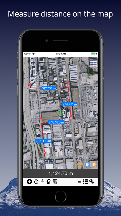
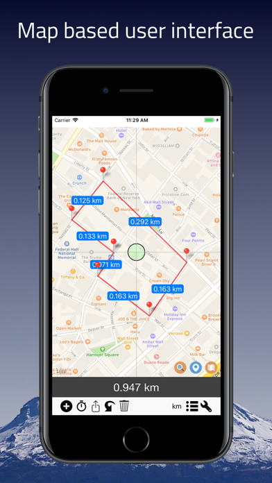
The DistancePinner app is designed to help users find the distance between two points on a map. It is useful for route planning, finding the shortest distance, traveling, and more. The app has a simple design and supports multiple unit types. It also has an advanced search feature and allows users to import coordinates from a text file. The app offers a subscription to remove ads.
1. Subscriptions may be managed by going to your iTunes Account Settings after purchase or by clicking the “Purchase / Manage Subscription.
2. Export list of coordinates in latitude and longitude plus the total distance via email.
3. Auto-renewal may be turned off by going to Account Settings after purchase.
4. Useful for route planning, finding shortest distance, traveling, and many more.
5. Device subscriptions are available in these plan and will renew automatically each month, six months or year, unless cancelled.
6. Move map around and drop pins to start measuring distance.
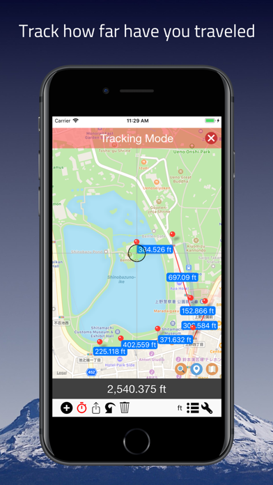
7. You can use device's GPS feature to measure distance on the go.
8. Subscription automatically renews unless auto-renew is turned off at least 24-hours before the end of the current period.
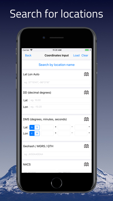
9. Import coordinates list from text file.
10. Find the distance between the points on the map easy with this app.
11. Type in coordinates in various formats such as MGRS, GARS, UTM, and many more.
12. Liked DistancePinner? here are 5 Utilities apps like My Verizon; myAT&T; My Spectrum; Google; T-Mobile;
GET Compatible PC App
| App | Download | Rating | Maker |
|---|---|---|---|
 DistancePinner DistancePinner |
Get App ↲ | 231 4.75 |
Mapnitude Company Limited |
Or follow the guide below to use on PC:
Select Windows version:
Install DistancePinner app on your Windows in 4 steps below:
Download a Compatible APK for PC
| Download | Developer | Rating | Current version |
|---|---|---|---|
| Get APK for PC → | Mapnitude Company Limited | 4.75 | 3.6.7 |
Get DistancePinner on Apple macOS
| Download | Developer | Reviews | Rating |
|---|---|---|---|
| Get Free on Mac | Mapnitude Company Limited | 231 | 4.75 |
Download on Android: Download Android
- Simple design
- Distance Tracking Mode using device's GPS feature
- Supports multiple unit types
- Advanced search feature
- Import from text file
- Export and Edit feature
- Sharing feature
- Subscription to remove ads
- Accurate measuring tool for straight lines or multiple lines
- Useful for setting boundaries or measuring distances
- Easy to use features and multiple plotting pins
- Great map for comparing locations or routes
- App crashes when trying to save an image
- No option to switch on/off the blue auto-locator or pinpoint vertical/horizontal lines
- No ability to rename saved paths
- Some users have experienced crashes when exporting maps as images
Great App!
Great tool!!
Constant crashes
Great app, perfect!
 PC Apps