Written by James Associates Inc.
Get a Compatible APK for PC
| Download | Developer | Rating | Score | Current version | Adult Ranking |
|---|---|---|---|---|---|
| Check for APK → | James Associates Inc. | 0 | 0 | 9.4.5 | 4+ |
What is iSailGPS NZ?
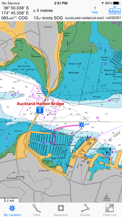
iSailGPS NZ is a navigation app that turns your iPhone or iPad into a high-performance GPS receiver, even in areas with no cell signal. It provides access to all LINZ NZ Mariner Raster Nautical Charts without any extra charge, subscription, or in-app purchase. The app allows you to record tracks, mark waypoints, create routes, and navigate to your destination with advanced features like COG, HDG, BRG, XTE, VMG, and ETA. You can also view and share the sun and moon position and rise & set times for any place on earth. The app supports different units of measurement and grid systems, and it comes with a comprehensive help section.
1. The Land Information New Zealand raster nautical charts in iSailGPS NZ differ from computer-drawn vector charts in that each chart covers a specific area, the same way a paper nautical chart does.
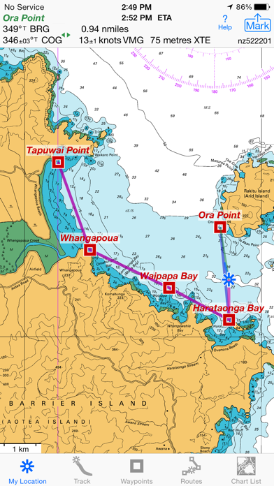
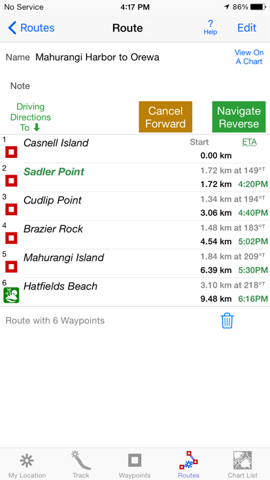
2. Set a quick GoTo waypoint or a full route and see the course (COG), heading (HDG), bearing (BRG), direction, distance, cross track error (XTE), Velocity Made Good (VMG) and Estimated Time of Arrival (ETA) at your destination and intermediate points.
3. No extra charge for access to all LINZ NZ Mariner Raster Nautical Charts, with no sign up, no subscription, no in-app purchase required.
4. Mark waypoints by their position on a chart or satellite map, by searching for a place name or address, by tapping a geotagged photo, or by projecting from a known point.
5. Paper charts can contain multiple panels, each showing a different area or scale.
6. Enjoy the high resolution and what's-all-around detail of the NZMariner Raster Nautical Charts (RNC).
7. Stitches Mercator charts for seamless coverage across chart boundaries.
8. Charts from our server have a shorter download time and use less of your monthly data allotment.
9. For many locations, there are multiple charts at different scales with different levels of detail & areas of coverage.
10. They are a welcome advantage over Vector Charts, which only show a coastline, depths, navigation aids, and minimal details.
11. Store a few charts or charts for the whole country to use anytime at sea without cell service.
12. Liked iSailGPS NZ? here are 5 Navigation apps like Marine Alaska S. E. GPS Charts; Marine Rules & Signals; iNavX: Marine Navigation; Boating Marine & Lakes; i-Boating: Marine Charts & Gps;
Not satisfied? Check for compatible PC Apps or Alternatives
| App | Download | Rating | Maker |
|---|---|---|---|
 isailgps nz nz marine charts isailgps nz nz marine charts |
Get App or Alternatives | 0 Reviews 0 |
James Associates Inc. |
Select Windows version:
Download and install the iSailGPS NZ : NZ Marine Charts app on your Windows 10,8,7 or Mac in 4 simple steps below:
To get iSailGPS NZ on Windows 11, check if there's a native iSailGPS NZ Windows app here » ». If none, follow the steps below:
| Minimum requirements | Recommended |
|---|---|
|
|
iSailGPS NZ : NZ Marine Charts On iTunes
| Download | Developer | Rating | Score | Current version | Adult Ranking |
|---|---|---|---|---|---|
| $2.99 On iTunes | James Associates Inc. | 0 | 0 | 9.4.5 | 4+ |
Download on Android: Download Android
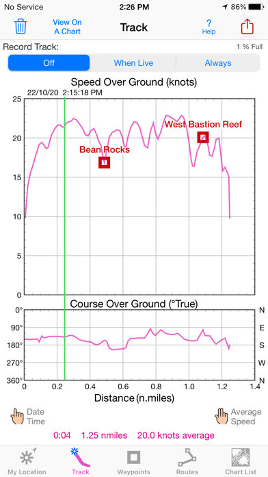
- Record tracks and view them on the chart and in a speed and course graph
- Mark waypoints by position, place name, address, geotagged photo, or projection
- Set a quick GoTo waypoint or a full route with advanced navigation features
- Man Overboard feature to mark your current position and navigate to it
- Create routes using waypoints, recorded tracks, or imported GPX, KML, or TCX files
- Export GPX and KML files via email, messages, copy to, AirDrop, iCloud Drive, Dropbox, or iTunes
- View and share the sun and moon position and rise & set times for any place on earth
- Access all LINZ NZ Mariner Raster Nautical Charts without any extra charge, subscription, or in-app purchase
- Store charts for the whole country to use anytime at sea without cell service
- Switch automatically between downloaded charts as you sail and choose detailed or overview charts
- Stitch Mercator charts for seamless coverage across chart boundaries
- Print and share chart images overlaid with waypoints, routes, and tracks
- Measure distance between any two points
- Support different units of measurement and grid systems
- Comprehensive help section and online manual
- Compatible with iPhone 4S or later and all WiFi+cellular iPads, and requires an iOS-compatible external GPS receiver for iPad 2 or later with WiFi-only and iPod touch (5th gen or later)
 PC Apps