Published by NavX Studios LLC on 2025-03-24


What is iNavX?
iNavX is a handheld chartplotter app that provides complete worldwide chart coverage, weather forecasts, AIS integration, and more. It is designed for sailors, boaters, and anglers to plan sailing routes, manage boating equipment, and discover new fishing spots. The app offers advanced features such as chart plotting, navigation, instrumentation, and essential toolkit.
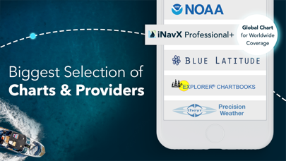
1. iNavX is Compatible with: C-MAP, Theyr Weather, Waterway Guide, AIS, Brookhouse, DigitalYacht, ShipModul, vYacht, Vesper Marine, NMEA 2000, Chetco and more.
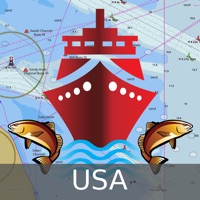
2. Download iNavX TODAY and automatically receive a complimentary copy of the official and up-to-date high-resolution NOAA RNC United States marine raster charts.
3. Chart subscriptions vary by chart and provider from $9.99 to $199.99 annually, charged to your iTunes Account, which will automatically renew unless cancelled at least 24 hours before the end of the current period.
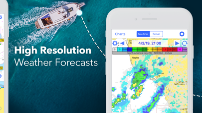
4. Get proactive sail management with GRIB weather forecasts and then keep watch with AIS overlays and integration with your onboard systems.
5. Manage your boating equipment with nautical instrument integration and then save great boating routes to share with the track log.
6. • Boaters - Stay up to date on boating conditions with forecasts that include currents, winds, and swells.
7. Locate the best fishing conditions by identifying cold fronts and save your best fishing spots with unlimited markers.
8. Marine navigation is made easy with iNavX - the world's #1 handheld Chartplotter.
9. Auto-renew can be turned off anytime by going to your Account Settings in iTunes after purchase.
10. • Sailors - Plan sailing routes with waypoint and route management.
11. • Anglers - Discover new fishing spots by scouting out holes and inlets.
12. Liked iNavX? here are 5 Navigation apps like Marine Alaska S. E. GPS Charts; Marine Rules & Signals; Boating Marine & Lakes; i-Boating: Marine Charts & Gps;
Or follow the guide below to use on PC:
Select Windows version:
Install iNavX: Marine Navigation app on your Windows in 4 steps below:
Download a Compatible APK for PC
| Download | Developer | Rating | Current version |
|---|---|---|---|
| Get APK for PC → | NavX Studios LLC | 4.76 | 5.6.40 |
Get iNavX on Apple macOS
| Download | Developer | Reviews | Rating |
|---|---|---|---|
| Get $4.99 on Mac | NavX Studios LLC | 19764 | 4.76 |
Download on Android: Download Android
- Complete worldwide chart coverage from multiple providers
- Plan sailing routes with waypoint and route management
- Get proactive sail management with GRIB weather forecasts
- Keep watch with AIS overlays and integration with onboard systems
- Geotag photos to remember great sailing locations
- Stay up to date on boating conditions with forecasts that include currents, winds, and swells
- Manage boating equipment with nautical instrument integration
- Save great boating routes to share with the track log
- Discover new fishing spots by scouting out holes and inlets
- Identify cold fronts to locate the best fishing conditions
- Save best fishing spots with unlimited markers
- Advanced chart plotter with real-time position plotting, pan, zoom, and rotate charts
- Print detailed charts to use in combination with the app
- Advanced navigation with waypoint creation, route planning, and track log recording
- Import/export data in KML or GPX format
- Advanced instrumentation with NMEA data support, external GPS and AIS receiver integration, and nautical instrument connection
- Essential toolkit with GRIB weather forecast, tides/currents, anchor alarm, AIS integration, and port/navaid search
- Compatible with various providers such as C-MAP, Theyr Weather, Waterway Guide, AIS, Brookhouse, DigitalYacht, ShipModul, vYacht, Vesper Marine, NMEA 2000, Chetco, and more
- Chart subscriptions vary by chart and provider from $9.99 to $199.99 annually, charged to your iTunes Account, which will automatically renew unless cancelled at least 24 hours before the end of the current period
- Auto-renew can be turned off anytime by going to your Account Settings in iTunes after purchase
- No cancellation of the current subscription is allowed during active subscription period
- Continued use of GPS running in the background can dramatically decrease battery life
- Website: http://inavx.com/
- User's Guide: http://inavx.com/help/
- Terms of Use: http://inavx.com/terms
- Privacy Policy: http://inavx.com/privacy
- Reliable and accurate navigation in various locations around the world
- Compliments a chart plotter well, especially with the ability to transfer waypoints
- Easy to use and update charts
- Redundancy with the ability to use on multiple devices
- Anchor alarm feature is useful for anchoring out
- Detailed Navionics charts are preferred
- No mention of any significant cons or issues with the app
Circumnavigated in 2 yrs
Good App, but...
Great nav program
Best app purchase ever!!!
 PC Apps