Last Updated by Ash Point Ltd. on 2025-04-28

What is Canadian Lease Locator?
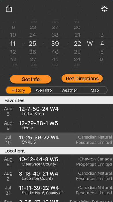
This app is an upgraded version of the Canadian Oilfield Lease Locator app and requires a subscription. It allows users to find locations, get turn-by-turn directions, view well data, weather forecasts, drop pins to see location names, and share well info and location with the Canadian Oilfield Lease Locator. The app has a simple yet powerful interface that makes it easy to use. Users can enter the legal land description to view the surface location or drop a pin on the map to view LSD and well info (if vertical). The app also allows users to view the current, future, and past weather specific to the location entered. Users can drop a pin on the map to see the LSD and well info for that location. The app stores the history of previously viewed wells/locations and allows users to share location and well info via message, email, Twitter, and more.
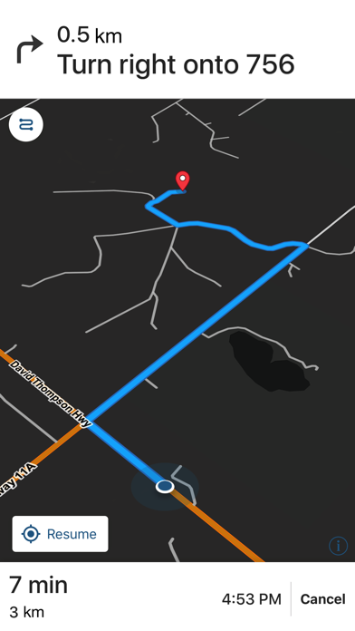
1. Find location, get turn-by-turn directions, AS WELL AS view well data, weather forecasts, drop pins to see location name, and share well info and location with the Canadian Oilfield Lease Locator.
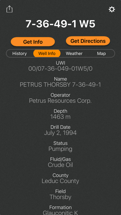
2. Enter downhole location and view well information such as the operating company, depth, drill date, current status, downhole fluid, formation of wells on record in Alberta.
3. Simply enter the legal land description to view the surface location OR drop a pin on the map to view LSD and well info (if vertical).
4. As long as turn by turn navigation is started before service is lost, the directions will continue to function so you don't have to worry about being stranded half way to location.
5. Wondering if the lease is too wet or has snow to be cleared? View the precipitation the location was forecasted to receive in the past three days.
6. Change the origin location to see step-by-step directions to location from the nearest town, useful for putting together ERPs or provide visitors directions.
7. The location can be opened in Apple or Google maps for turn by turn navigation.
8. Drop a pin on the map to see the LSD and well info (if the well is vertical) for that location.
9. This is the upgrade version from Canadian Oilfield Lease Locator, DO NOT PURCHASE, this app is just to maintain support for previous customers.
10. See the current, future AND past weather specific to the location entered.
11. This multifunctional lease locator app makes getting to work a breeze.
12. Liked Canadian Lease Locator? here are 5 Navigation apps like Canadian Land Access Systems; Google Maps; Waze Navigation & Live Traffic; ParkMobile: Park. Pay. Go.; Transit • Subway & Bus Times;
Or follow the guide below to use on PC:
Select Windows version:
Install Canadian Lease Locator app on your Windows in 4 steps below:
Download a Compatible APK for PC
| Download | Developer | Rating | Current version |
|---|---|---|---|
| Get APK for PC → | Ash Point Ltd. | 1 | 2.2.412 |
Get Canadian Lease Locator on Apple macOS
| Download | Developer | Reviews | Rating |
|---|---|---|---|
| Get $69.99 on Mac | Ash Point Ltd. | 0 | 1 |
Download on Android: Download Android
- Find location and get turn-by-turn directions
- View well data, weather forecasts, and drop pins to see location names
- Share well info and location with the Canadian Oilfield Lease Locator
- Simple yet powerful interface
- Enter legal land description to view surface location or drop a pin on the map to view LSD and well info (if vertical)
- Open locations in Apple or Google maps for turn-by-turn navigation
- View downhole location and well information such as the operating company, depth, drill date, current status, downhole fluid, formation of wells on record in Alberta
- View current, future, and past weather specific to the location entered
- See location in the app and view with standard, hybrid, or satellite imagery
- Store history of previously viewed wells/locations
- Share location and well info via message, email, Twitter, and more
- Drop pins on the map to see that location's LSD and well info
- Turn-by-turn navigation continues to function even without cell service
- iCloud support syncs history between compatible devices and creates a backup
- LSD's work for Alberta, Saskatchewan, and Manitoba. Currently only well LSD's are supported for BC. Also, NTS works for BC.
- Downhole well data currently available for Alberta and BC. Saskatchewan and Manitoba will be coming soon.
- Previous weather is based on previous forecasts, not what the location actually received.
 PC Apps