Last Updated by JOMO Solutions Ltd on 2025-04-26

What is Snowdonia Maps Offline? Snowdonia Maps is an app that provides beautifully detailed maps supplied by Ordnance Survey. It is an offline mapping reference and navigation aid that can be used while travelling throughout Snowdonia by footpath, road, rail, canal, lake, and river. The app has intuitive route and waypoint management features that enable creation, modification, deletion, import, and export of routes. It also has a powerful offline search facility that can locate places, roads, postcodes, and hills within the region. Worldwide online Apple Maps (Standard, Satellite, and Hybrid) with map features that users are used to are available on both offline and online maps as well as providing 3D buildings on Apple maps (where available).
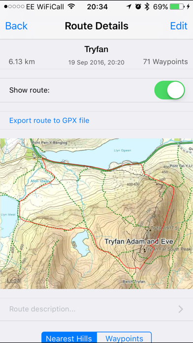
1. Snowdonia Maps provides a useful offline (no mobile signal required) mapping reference and navigation aid whilst travelling throughout Snowdonia by footpath, road, rail, canal, lake and river.
2. Worldwide online Apple Maps (Standard, Satellite and Hybrid) with map features that users are used to are available on both offline and online maps as well as providing 3D buildings on Apple maps (where available).
3. 7 different levels of offline 2014/2015 Ordnance Survey map detail from national overview to street view within the region.
4. The data is supplied by Apple, Ordnance Survey, contributors to OpenStreetMap and Database of British and Irish Hills.
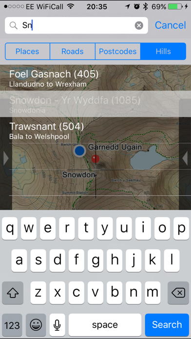
5. A powerful offline search facility can locate places, roads, post codes and hills within the region.
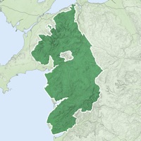
6. The map region of the more detailed maps covers a rectangular region around the national park boundary (ref.
7. The Information is licensed 'as is' and the Information Provider and/or Licensor excludes all representations, warranties, obligations and liabilities in relation to the Information to the maximum extent permitted by law.
8. The Information Provider and/or Licensor are not liable for any errors or omissions in the Information and shall not be liable for any loss, injury or damage of any kind caused by its use.
9. Beautifully detailed maps supplied by Ordnance Survey.
10. - Offline search functionality with searchable locations (places, roads, post codes and hills).
11. The OS search data was published by Ordnance Survey in 2014.
12. Liked Snowdonia Maps Offline? here are 5 Navigation apps like Snowdonia Outdoor Map; Google Maps; Waze Navigation & Live Traffic; ParkMobile: Park. Pay. Go.; Transit • Subway & Bus Times;
GET Compatible PC App
| App | Download | Rating | Maker |
|---|---|---|---|
 Snowdonia Maps Offline Snowdonia Maps Offline |
Get App ↲ | 1 5.00 |
JOMO Solutions Ltd |
Or follow the guide below to use on PC:
Select Windows version:
Install Snowdonia Maps Offline app on your Windows in 4 steps below:
Download a Compatible APK for PC
| Download | Developer | Rating | Current version |
|---|---|---|---|
| Get APK for PC → | JOMO Solutions Ltd | 5.00 | 2.1.1 |
Get Snowdonia Maps Offline on Apple macOS
| Download | Developer | Reviews | Rating |
|---|---|---|---|
| Get $1.99 on Mac | JOMO Solutions Ltd | 1 | 5.00 |
Download on Android: Download Android
- 7 different levels of offline 2014/2015 Ordnance Survey map detail from national overview to street view within the region. (No data connection required)
- Progressively more detailed maps are automatically loaded as the map view is zoomed.
- Contours with height information and annotated height points
- Extensive footpaths from ©OpenStreetMap contributors
- National Park boundary demarcation
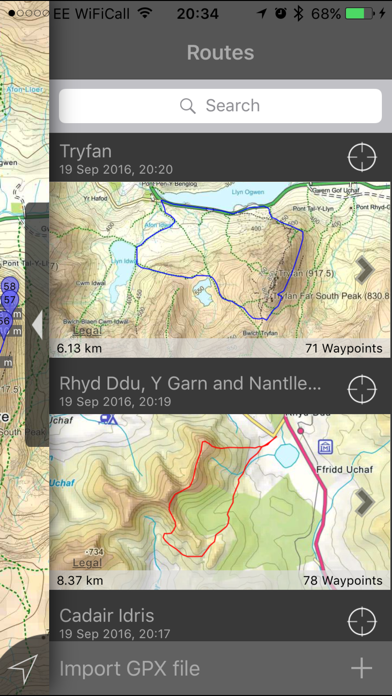
- Route/Waypoint management.
- Offline search functionality with searchable locations (places, roads, postcodes, and hills).
- Detailed hill information, including height, OS Grid Ref, latitude and longitude, region, parent, classification, drop and hill specific links to Streetmap, Geograph and Hill Bagging web sites
- Display of current GPS position as OS Grid Reference or WGS84 latitude and longitude
- "Share My Location" allowing users to share an image of their current location and location references. Buttons are provided to share location information by Facebook, Twitter, iMessage/SMS and e-mail
- Online access to worldwide Apple Standard, Satellite, and Hybrid maps
- Apple 3D Buildings are displayed on Apple Standard maps
- Apple maps contain Points of Interest
- User location can be tracked with or without heading on all online and offline maps (GPS capable devices only)
- Display of scale bar in either metric or imperial units
- Display of current speed
- Zoom, pan, rotation of all maps
- Pitch of Apple Standard and Ordnance Survey maps
- Selection of current location annotation for display of speed and location data
- User setting for speed display in Miles per Hour (mph) or Kilometres per Hour (kph)
- Selection of search result pin annotations to display location information
- Collective deletion of search result annotation pins
- A user guide is provided within the app.
 PC Apps