Last Updated by Blue Blink One, SL on 2025-02-22
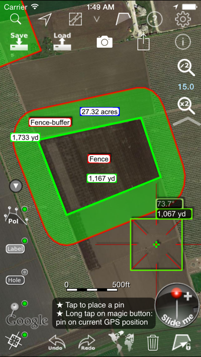
What is Agro Measure Map Pro? Agro Measure Map Pro is a powerful and portable measuring tool that allows you to measure multiple distances, perimeters, and areas with laser sharp precision. It takes into account the curvature of the earth's surface and provides you with totally precise measurements of any distance, from as small as one tenth of a meter to as big as thousands of kilometers or miles. The app is designed for field work and allows you to calculate surface areas, fields, plots, forest areas, or dimensions for fencing, spraying, plowing, or anything you need without having to go to the spot to take measurements.
1. Calculate surface areas, fields, plots, forest areas or dimensions for fencing, spraying, plowing or anything you need for field work without having to go to the spot to take measurements.
2. Agro Measure Map Pro lets you quickly and easily measure multiple distances, perimeters and areas with laser sharp precision! It even takes into account the curvature of the earth’s surface.
3. Your iPhone, iPod touch or iPad can now provide you with totally precise measurements of any distance, from as small as one tenth of a meter to as big as thousands of kilometers or miles.
4. Only one finger to calculate with astonishing accuracy all these measurements over satellite images.
5. That’s what Agro Measure Map Pro is for, to put a powerful, portable measuring tool right in the palm of your hand.
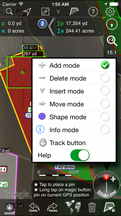
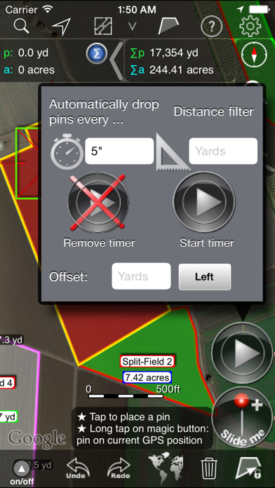
6. * Track mode: drops pins on current GPS position at regular intervals.
7. * More maps with extra zoom level through in-app purchase: Bing, Yahoo Maps, and ArcGIS.
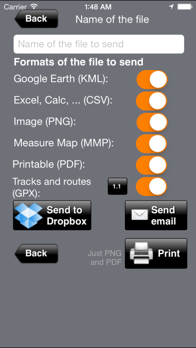
8. Use it for small areas or large, then share your findings via iTunes or email.
9. Enter a distance and Agro M.M. Pro will create a buffer area around any polygon.
10. - A Grid generator to calculate the number of seedlings and best position to maximise it.
11. * Displays Maps View: Map, Satellite, Hybrid and Terrain.
12. Liked Agro Measure Map Pro? here are 5 Utilities apps like Tape Measure™; Tape Measure®; CamToPlan - AR tape measure; GPS Fields Area Measure Map; Measure Map;
GET Compatible PC App
| App | Download | Rating | Maker |
|---|---|---|---|
 Agro Measure Map Pro Agro Measure Map Pro |
Get App ↲ | 23 4.52 |
Blue Blink One, SL |
Or follow the guide below to use on PC:
Select Windows version:
Install Agro Measure Map Pro app on your Windows in 4 steps below:
Download a Compatible APK for PC
| Download | Developer | Rating | Current version |
|---|---|---|---|
| Get APK for PC → | Blue Blink One, SL | 4.52 | 8.10.2 |
Get Agro Measure Map Pro on Apple macOS
| Download | Developer | Reviews | Rating |
|---|---|---|---|
| Get $74.99 on Mac | Blue Blink One, SL | 23 | 4.52 |
Download on Android: Download Android
- Attractive, smooth, easy navigation and use
- For iPhone and iPad
- Retina display
- Apple or Google Maps with extra zoom level
- Displays Maps View: Map, Satellite, Hybrid, and Terrain
- More maps with extra zoom level through in-app purchase: Bing, Yahoo Maps, and ArcGIS. And MapQuest, Open Street, Open Cycle, World Street, and more in the future
- Operations: Add, delete intermediate pins, insert between pins, move pins, get info
- Circles and rectangles
- Multiple areas and routes on screen
- Display of altitude above sea level, azimuth, and angle
- Undo and redo operations as needed
- AirPrint and iCloud support
- Calculates azimuth or bearing
- Search for current location, text (villages, places of interest, etc.) or an area or route
- Lots of longitude and surface measurement units
- Intermediate distances between pins can be displayed
- Ability to select color, thickness, and transparency
- Working format: Measure Map, KMZ, KML (Google Earth), CSV (Excel), GPX, Image (PNG), and PDF
- Export and import of surfaces and routes via e-mail, iTunes, AirDrop, and Dropbox
- Save to photo album
- Download surfaces and routes from the Internet
- Apple Pencil drawing mode (with iPad Pro)
Differences with the non-pro version:
- Calculates multiple areas and routes simultaneously
- Ability to create inner polygons as "holes"
- Drawing of shapes: circle and rectangle
- More maps with extra zoom level through in-app purchase
- Calculates azimuth or bearing
- Displays altitude above sea level, azimuth, and angle
- Imports KML, KMZ, and GPX format files besides exporting them
- Track mode: drops pins on current GPS position at regular intervals
- Coordinate system DM
- Apple Pencil drawing mode (with iPad Pro)
- Autosave
Agro exclusive
- A Buffer area generator. Enter a distance and Agro M.M. Pro will create a buffer area around any polygon
- A Grid generator to calculate the number of seedlings and best position to maximize it
- Split and join polygons for rearrangement of fields and crops
- More to come with your suggestions. Please send them to info@globaldpi.com.
The app is perfect for farmers, land surveyors, engineers, and anyone who needs to measure distances, perimeters, and areas with precision.
Directo of México operations
Does not work as advertised!
Doesn’t work
Good
 PC Apps