Last Updated by DigitalYacht Ltd. on 2024-10-01


What is NavLink UK? NavLink is a Mac app that turns your device into a full-function chart plotter for boating trips. It uses digital vector charts derived from the latest UKHO data covering the whole of the UK and Ireland. The app can be used as the primary electronic charting system on the boat or as the perfect backup system to an existing dedicated chart plotter. It includes all UK and Ireland charts, and buoys, lights, etc. are tappable with bearing and distance. The app offers seamless fast panning and zooming across charts, route planning and tracking with waypoints, SOG, COG, ETA, etc. It also provides live AIS ship overlay with CPA and TCPA alarms, and charts work offline.
1. NavLink lets you plan your routes and waypoints at home and once at sea, the app’s Sailing HUD gives you all of the navigation data you need including; Position, Course and Speed over ground (COG+SOG), Vector Made Good (VMG), Estimated Time of Arrival (ETA), Distance and bearing to next Waypoint and an alert when you reach the waypoint and NavLink auto-routes to the next one.
2. Turn your Mac in to a full function chart plotter, that lets you explore, plan and navigate your boating trips using Digital Vector charts derived from the latest UKHO data covering the whole of the UK and Ireland and included with the app.
3. Taking the GPS position and AIS data from your onboard navigation systems, NavLink can be used as the primary electronic charting system on the boat or as the perfect backup system to an existing dedicated chart plotter.
4. It is the Captain's or Boat Owner's responsibility to use official government charts, notice to mariners, caution, sound judgement and proper navigational skill when operating their vessel and using this or any other Digital Yacht product.
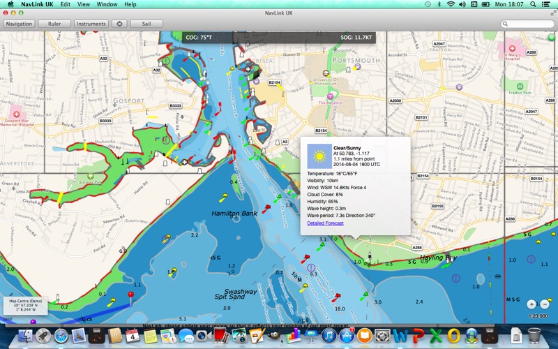
5. The UKHO Vector charts provide a wealth of information including; Buoys, Lights, Bridges, Depth Contours+Soundings, Rocks, Anchorage areas, Weather Buoys etc.
6. Your purchase of NavLink includes 12 months free updates to the included UK+Ireland chart set.
7. Only official government charts and notice to mariners contain all of the current information needed for safe navigation.
8. Connected to an AIS system, NavLink displays all AIS equipped vessels within VHF range and constantly monitors their position and track.
9. Should NavLink detect a vessel that is on a course that could potentially bring it too close to your own boat, then it will sound a CPA or TCPA alarm.
10. NavLink works with all Digital Yacht AIS units that have a USB or our wireless NMEA products; NavLink, WLN10, iNavHub, etc.
11. NavLink is also available for iOS, so you can plan a route on your Mac and share the route with your iPhone or iPad.
12. Liked NavLink UK? here are 5 Travel apps like Lyft; Uber - Request a ride; United Airlines; Southwest Airlines; Fly Delta;
Or follow the guide below to use on PC:
Select Windows version:
Install NavLink UK app on your Windows in 4 steps below:
Download a Compatible APK for PC
| Download | Developer | Rating | Current version |
|---|---|---|---|
| Get APK for PC → | DigitalYacht Ltd. | 1 | 2.5 |
Get NavLink UK on Apple macOS
| Download | Developer | Reviews | Rating |
|---|---|---|---|
| Get $34.99 on Mac | DigitalYacht Ltd. | 0 | 1 |
Download on Android: Download Android
- Full-function chart plotter for boating trips
- Uses digital vector charts derived from the latest UKHO data covering the whole of the UK and Ireland
- Can be used as the primary electronic charting system on the boat or as the perfect backup system to an existing dedicated chart plotter
- Includes all UK and Ireland charts
- Buoys, lights, etc. are tappable with bearing and distance
- Offers seamless fast panning and zooming across charts
- Provides route planning and tracking with waypoints, SOG, COG, ETA, etc.
- Offers live AIS ship overlay with CPA and TCPA alarms
- Charts work offline
- Provides route export, import, and sharing
- Allows sharing routes with NavLink on iOS
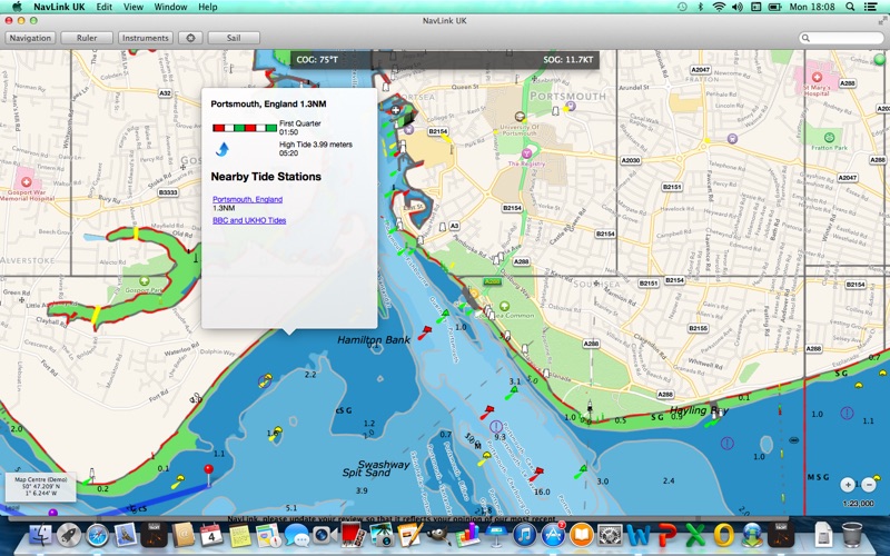
- Provides tides, moon and sun times, and weather information
- Offers Sailing HUD that gives all of the navigation data needed including position, course, and speed over ground (COG+SOG), Vector Made Good (VMG), Estimated Time of Arrival (ETA), distance and bearing to next waypoint, and an alert when you reach the waypoint
- Connected to an AIS system, NavLink displays all AIS equipped vessels within VHF range and constantly monitors their position and track
- Sounds a CPA or TCPA alarm if NavLink detects a vessel that is on a course that could potentially bring it too close to your own boat
- Available for iOS, so you can plan a route on your Mac and share the route with your iPhone or iPad
- Real-time route navigation requires a GPS location which can be provided by our GPS150 USB sensor or AIT2000 transponder
- Works with all Digital Yacht AIS units that have a USB or our wireless NMEA products; NavLink, WLN10, iNavHub, etc. which provide location or AIS service via TCP or UDP
- Purchase of NavLink includes 12 months free updates to the included UK+Ireland chart set
- Safety notice: NavLink (including the charts) is intended to be used as an aid to navigation. Only official government charts and notice to mariners contain all of the current information needed for safe navigation.
 PC Apps