Last Updated by Navitel on 2025-04-20
What is Navitel Navigator? Navitel Navigator is an offline navigation app that provides detailed maps of 66 countries. It offers free geosocial services and a 7-day free trial. The app has several advantages, including offline navigation, no additional expenses on roaming, and no dependency on a mobile connection. It also has special features such as Navitel.Traffic, Navitel.Friends/Cloud, Navitel.Weather, Dynamic POI, Navitel.Events, SpeedCam warnings, 3D Mapping, 3D Road interchanges, Lane Assist, Multilanguage support, Turn-by-turn voice guidance, Dashboard, Fast route calculation, Unlimited number of waypoints for routing, Customizable user interface, and Multitouch support.
1. Albania, Andorra, Armenia, Argentina, Austria, Azerbaijan, Belarus, Belgium, Bosnia and Herzegovina, Brazil, Bulgaria, Colombia, Croatia, Cyprus, Czech Republic, Denmark, Estonia, Finland, France, Georgia, Germany, Gibraltar, Greece, Hungary, Iceland, India, Iran, Isle of Man, Italy, Kazakhstan, Kyrgyzstan, Latvia, Liechtenstein, Lithuania, Luxembourg, Macedonia, Maldives, Malta, Mexico, Moldova, Monaco, Mongolia, Montenegro, Netherlands, Norway, Pakistan, Peru, Philippines, Poland, Portugal, Romania, Russia, San Marino, Serbia, Slovakia, Slovenia, Spain, Sweden, Switzerland, Tajikistan, Turkey, Ukraine, United Kingdom, Uzbekistan, Vatican City State, Vietnam.
2. • Navitel.Events. Road accidents, road works, speed cams, and other events marked on the map by users.
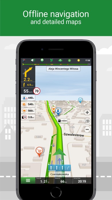
3. Navitel Navigator is precise offline navigation with free geosocial services and detailed maps of 66 countries.
4. • Navitel.Traffic. Information on all traffic jams in the covered area, available in real-time.
5. Voice guidance while moving along the route, warnings on the battery charge, and connection to the satellites.
6. Program settings and waypoints are stored in the NAVITEL cloud storage.
7. • Navitel.Weather. Weather forecast information for the next three days anywhere in the world.
8. • Navitel.Friends/Cloud. Messaging with friends, tracking their location, and routing towards them.
9. Purchase new map packages and update the purchased ones through the "My Navitel" menu.
10. No Internet connection required for the use of the program and maps: No additional expenses on roaming or dependency on a mobile connection.
11. Support of the interface and voice prompts in multiple languages.
12. Liked Navitel Navigator? here are 5 Navigation apps like Yandex Maps & Navigator; ÖPNV Navigator; MapFactor Navigator - GPS Maps; VZ Navigator; NaviGator for Gainesville RTS;
Or follow the guide below to use on PC:
Select Windows version:
Install Navitel Navigator app on your Windows in 4 steps below:
Download a Compatible APK for PC
| Download | Developer | Rating | Current version |
|---|---|---|---|
| Get APK for PC → | Navitel | 1 | 9.15.120 |
Download on Android: Download Android
- Offline navigation
- Offline maps of 66 countries available for purchase
- Map subscription for a limited period (1 year) with prices starting at 10.99$
- Navitel.Traffic for real-time traffic information
- Navitel.Friends/Cloud for messaging with friends, tracking their location, and routing towards them
- Navitel.Weather for weather forecast information for the next three days anywhere in the world
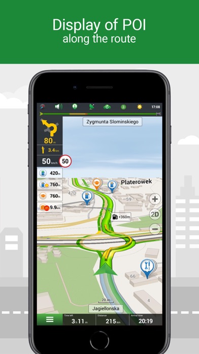
- Dynamic POI for fuel prices, movie showtimes, and other useful information
- Navitel.Events for road accidents, road works, speed cams, and other events marked on the map by users
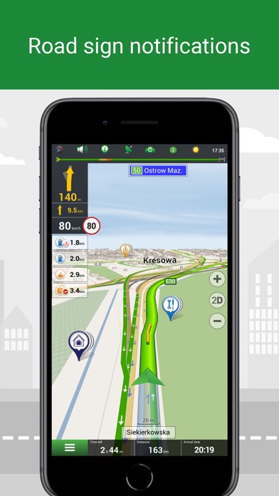
- SpeedCam warnings for information on radars, video recording cameras, and speed bumps
- 3D Mapping for three-dimensional maps with texture and number of floors support
- 3D Road interchanges for displaying multilevel road interchanges in 3D mode
- Lane Assist for route calculations taking multilane traffic into account and visual prompts while following the route
- Multilanguage support for the interface and voice prompts in multiple languages
- Turn-by-turn voice guidance for voice guidance while moving along the route, warnings on the battery charge, and connection to the satellites
- Dashboard for more than 100 different gauges: time, speed, weather, and other parameters
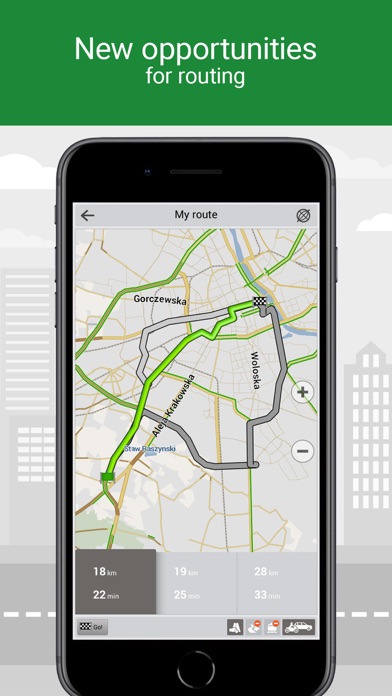
- Fast route calculation for instant calculation and routing of any length and complexity
- Unlimited number of waypoints for routing for easy routing with a limitless number of waypoints
- Customizable user interface for adapting the program interface and map display mode for your own needs
- Multitouch support for quick access to map scaling and rotation functions via the multitouch input
- Purchase through the program menu for purchasing new map packages and updating the purchased ones through the "My Navitel" menu.
- User-friendly interface with detailed information on speed cameras and regulations
- Option to turn off sound alerts for safer driving
- Clear and easy-to-spot color indications for navigation
- High-quality maps with detailed information
- Lack of voice-activated search feature
- No support for Arabic language and voice guidance
- Unclear information on the duration of the paid Europe maps (1 year or lifetime)
Jane
Igor
Application is very good but i have some Notes
Maps period
 PC Apps