Last Updated by AL-RADADI STUDIO (PRIVATE) LIMITED. on 2025-04-02


What is GPS Navigation Maps?
GPS Navigation Maps is a mobile application that provides turn-by-turn 3D view and complete regulation on how to arrive at a given destination. The app uses an internet connection to a GPS navigation system and normally uses a GPS satellite connection to determine its existing location. It guides the user throughout their journey from starting to the ending point. The app also displays the user's progress along the route and issues instructions for each turn. It keeps the user up-to-date about the best route to the destination and is often updated according to changing factors such as traffic and road conditions.
1. The application uses an Internet connection to a GPS navigation system to provide turn-by-turn 3D view and provide a path by complete regulation how to arrive at a given destination.
2. GPS navigation maps is a mobile application which guide the user throughout his journey from starting to the ending point.
3. The application requires connection to Internet data (e.g. 3G, 4G, Wi-Fi, etc.) and normally uses a GPS satellite connection to determine its existing location.
4. The App keeps the user up-to-date about the best route to the destination, and is often updated according to changing factors such as traffic and road conditions.
5. A user can enter a destination into the application, which will plot a path to it.
6. The App will also having a feature of nearby which guide the user about near places such as airport guide, malls, gas station by gps location tracker.
7. GPS navigation maps is an Application through which you can find a way to many place.
8. The app displays the user's progress along the route and issues instructions for each turn.
9. The App display the panoramic view to the gps pedestrian.
10. Liked GPS Navigation Maps? here are 5 Navigation apps like Waze Navigation & Live Traffic; Sygic GPS Navigation & Maps; what3words: Navigation & Maps; iNavX: Marine Navigation; MapQuest GPS Navigation & Maps;
GET Compatible PC App
| App | Download | Rating | Maker |
|---|---|---|---|
 GPS Navigation Maps GPS Navigation Maps |
Get App ↲ | 0 1 |
AL-RADADI STUDIO (PRIVATE) LIMITED. |
Or follow the guide below to use on PC:
Select Windows version:
Install GPS Navigation Maps app on your Windows in 4 steps below:
Download a Compatible APK for PC
| Download | Developer | Rating | Current version |
|---|---|---|---|
| Get APK for PC → | AL-RADADI STUDIO (PRIVATE) LIMITED. | 1 | 1.4 |
Get GPS Navigation Maps on Apple macOS
| Download | Developer | Reviews | Rating |
|---|---|---|---|
| Get Free on Mac | AL-RADADI STUDIO (PRIVATE) LIMITED. | 0 | 1 |
Download on Android: Download Android
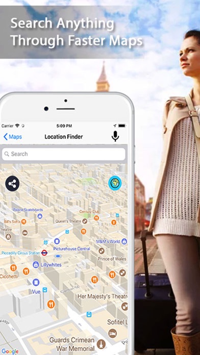
- Location Finder (Current Location / Search Location)
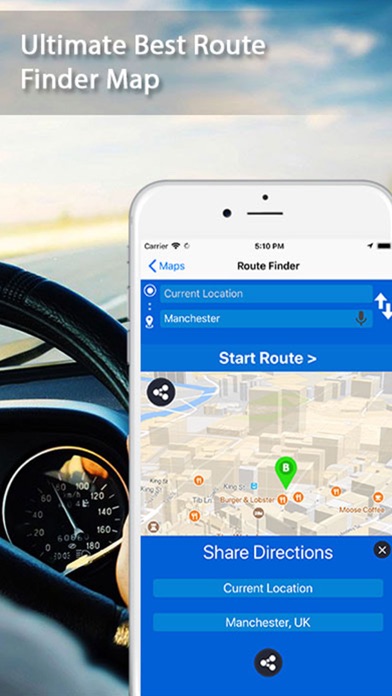
- Route Finder (From point A to point B)
- Live Traffic (Live traffic from all around the world)
- Street View (Panoramic View of places)
- Nearby Places (80+ nearby places from current location in 1000m radius)
- Internet connection to a GPS navigation system
- GPS satellite connection to determine existing location
- Plot a path to the destination
- Display the user's progress along the route
- Issue instructions for each turn
- Keep the user up-to-date about the best route to the destination
- Update according to changing factors such as traffic and road conditions
- Guide the user about near places such as airport guide, malls, gas station by GPS location tracker.
 PC Apps