Last Updated by George Remigius Gonsalves Borrageiro on 2025-07-02

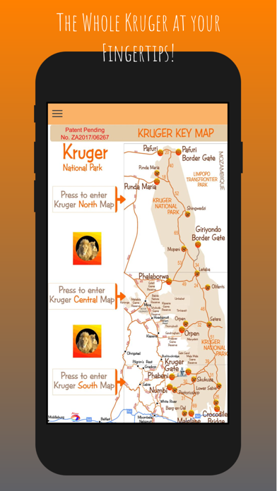

What is Kruger Map App? The Kruger Park map app and offline guide is a comprehensive and updated guide for those planning to visit the Kruger National Park. It includes offline maps, informational audio and video on historical sites, picnic spots, camp sites, local named animals, and much more. The app also features hand-drawn and up-to-date maps of the entire Kruger National Park, with GPS coordinates, places of interest, picnic spots, camp layouts, birding hides, and other features to make your safari experience exciting and memorable.
1. The highly detailed maps included, explore the Kruger and its Private lodges and surrounding areas with colorful photos and videos of its wildlife, historical sites, GPS co-ordinates, places of interest, Picnic spots, Camp layouts, Birding hides and many other features to make your safari experience an exciting and memorable one.
2. Using Years of experience in mapping and with a love for the Kruger National park region Tourist Window has brought the Mpumalanga region to life with colorful illustrations and the most accurate maps, images and facts available to make your stay one you will never forget.
3. A new age of cellular talking maps? This new dynamic, no data needed, concept of having a talking map on your cellular phone that can better inform you of interesting facts and features on your holiday destination, starting with the Kruger National Park.
4. The maps feature hundreds of markers indicationg the locations of the Entrance gates, camps, Bird hides, Picnic spots, roads, dams, view sites and animal sillouttes.
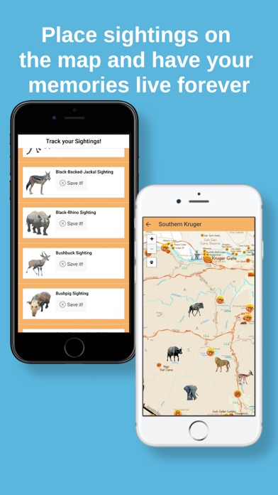
5. Again, tapping the placed picture on the road will activate the cellular camera, where a photo of the feature can be taken which is then saved at the exact spot where the sighting happened.
6. On spotting game in the park simply depress a finger on the screen at the road where you are which then causes a list of the animal, and bird pictures to appear.
7. This newly updated, popular and informative Kruger Park map app and offline guide is a must for those planning to visit the Kruger on safari into the wild.
8. • Informational audio and video on every historical site, picnic spot, camp site, local named animals and much much more.
9. tapping the photo causes a video clip to play accompanied by a voice explaining the feature.
10. • Complete map of the entire Kruger National Park.
11. All main camp maps showing facilities are also featured.
12. Liked Kruger Map App? here are 5 Travel apps like Kruger Game Finder; Kruger National Park; Kruger National Park Tourism Guide; Lyft; Uber - Request a ride;
GET Compatible PC App
| App | Download | Rating | Maker |
|---|---|---|---|
 Kruger Map App Kruger Map App |
Get App ↲ | 0 1 |
George Remigius Gonsalves Borrageiro |
Or follow the guide below to use on PC:
Select Windows version:
Install Kruger Map App app on your Windows in 4 steps below:
Download a Compatible APK for PC
| Download | Developer | Rating | Current version |
|---|---|---|---|
| Get APK for PC → | George Remigius Gonsalves Borrageiro | 1 | 1.0.1.1 |
Get Kruger Map App on Apple macOS
| Download | Developer | Reviews | Rating |
|---|---|---|---|
| Get $5.99 on Mac | George Remigius Gonsalves Borrageiro | 0 | 1 |
Download on Android: Download Android
- Offline maps of the Kruger National Park that work without any signal needed
- Informational audio and video on every historical site, picnic spot, camp site, local named animals, and much more
- Complete map of the entire Kruger National Park
- Save your sightings on the map with your own photos
- Hand-drawn and up-to-date maps of the Kruger National Park
- Advanced mapping techniques with hundreds of markers indicating the locations of entrance gates, camps, bird hides, picnic spots, roads, dams, view sites, and animal silhouettes
- Tap a marker to see a photo of the feature and tap the photo to play a video clip accompanied by a voice explaining the feature
- Depress a finger on the screen to list the animal and bird pictures and place them on the road where you saw them
- Take a photo of the feature and save it at the exact spot where the sighting happened
- All main camp maps showing facilities are also featured.
 PC Apps