Last Updated by DigitalYacht Ltd. on 2024-04-03
What is NavLink HD? The Marine Navigation App is designed to turn your Apple device into a full-function chart plotter. It includes navigation, AIS, and NMEA instrument tools, as well as trip planning features. The app offers a catalog of high-resolution vector charts that provide coverage across the US, including the US Great Lakes, CA, UK & Ireland, Germany, France, Netherlands, Belgium, Denmark, and Spain, which are available via separate In-App Purchases.
1. It is the Captain's or Boat Owner's responsibility to use official government charts, notice to mariners, caution, sound judgement and proper navigational skill when operating their vessel and using this or any other Digital Yacht product.
2. · NavLink Pro - provides live internet AIS feeds for your area and an Augmented Reality HorizonView showing course, route, navaids, AIS targets, POIs and Air Draught on the camera display that makes Nav-Aid and vessel identification simple and reliable.
3. · Marine Charts - Yearly subscriptions for charts using the latest Hydrographic Office data including automatic updates for a year.
4. A catalog of high resolution vector charts providing coverage across US including US Great Lakes, CA, UK & Ireland, Germany, France, Netherlands, Belgium, Denmark and Spain are available via separate In App Purchases.
5. Only official government charts and notice to mariners contain all of the current information needed for safe navigation.
6. Our in-app purchases are 1 year subscriptions, which automatically renew at the end of the subscription period unless auto-renew is turned off at least 24-hours before the end of the current period.
7. NavLink utilises the latest S57 based digital mapping and features automatic updates for each year's subscription.
8. Payment will be charged to your iTunes Account at confirmation of purchase, and will be charged for renewal within 24-hours prior to the end of the current period.
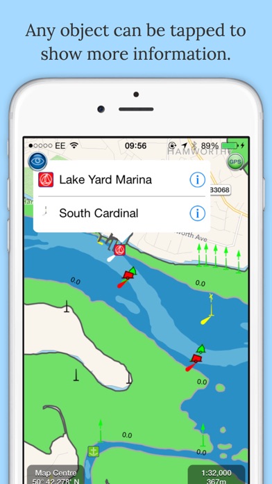
9. NavLink supports all key charting feature such as buoys, lights, bridges, depth contours, spot depths, depth contours, anchorage and military areas etc.
10. Subscriptions may be managed by the iTunes account holder and auto-renewal may be turned off by going to Account Settings after purchase.
11. Marine Navigation App that turns your Apple Device in to a full function chart plotter.
12. Liked NavLink HD? here are 5 Navigation apps like Google Maps; Waze Navigation & Live Traffic; ParkMobile: Park. Pay. Go.; Transit • Subway & Bus Times; Yahoo!カーナビ;
Or follow the guide below to use on PC:
Select Windows version:
Install NavLink HD app on your Windows in 4 steps below:
Download a Compatible APK for PC
| Download | Developer | Rating | Current version |
|---|---|---|---|
| Get APK for PC → | DigitalYacht Ltd. | 4.18 | 5.4.5 |
Get NavLink HD on Apple macOS
| Download | Developer | Reviews | Rating |
|---|---|---|---|
| Get Free on Mac | DigitalYacht Ltd. | 11 | 4.18 |
Download on Android: Download Android
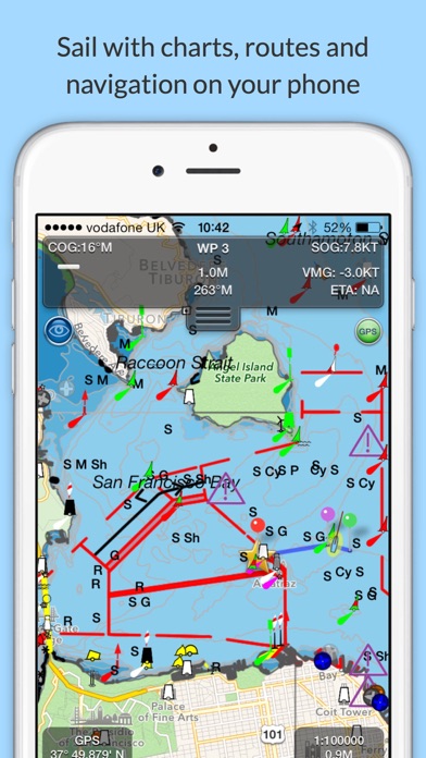
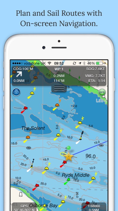
The free features of the app include Realtime GPS position plotted on the map, Live AIS ship overlay when connected to compatible wireless AIS system via a wireless NMEA link with CPA and TCPA alarms, NMEA Wind Speed and Direction gauges, Waypoints and routes with full route editing and planning function, Position, COG, SOG, VMG, bearing, distance, and ETA displays, Weather buoy data, A-B chart ruler for quick and easy bearing and distance measurement, and Favourite Place markers (POIs).
Additional features available via In-App Purchase subscription include Marine Charts - Yearly subscriptions for charts using the latest Hydrographic Office data including automatic updates for a year, and NavLink Pro - provides live internet AIS feeds for your area and an Augmented Reality HorizonView showing course, route, navaids, AIS targets, POIs, and Air Draught on the camera display that makes Nav-Aid and vessel identification simple and reliable.
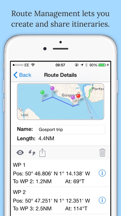
The app allows you to plan and sail routes, with instant route and waypoint creation by tapping on the screen. Route reverse function and route overview with inter-leg bearing and distance. You can share your routes via Dropbox and email with other users. NavLink Charting utilises the latest S57 based digital mapping and features automatic updates for each year's subscription. With vector mapping, you can manage your layers of data to de-clutter the screen or maximise information. NavLink supports all key charting feature such as buoys, lights, bridges, depth contours, spot depths, depth contours, anchorage and military areas etc.
NavLink is compatible with all Digital Yacht's wireless NMEA devices such as the iAIS, WLN10, WLN10HS, NavLink, iNavHub and PilotLink that stream wireless AIS data to your Apple device. If you have a WiFi-only iPad, you will need an external Bluetooth GPS receiver to enable navigation. 3rd Party units are available such as the Garmin Glo.
Please note that continued use of GPS running in the background can dramatically decrease battery life. The app's in-app purchases are 1-year subscriptions, which automatically renew at the end of the subscription period unless auto-renew is turned off at least 24-hours before the end of the current period. Payment will be charged to your iTunes Account at confirmation of purchase, and will be charged for renewal within 24-hours prior to the end of the current period. Subscriptions may be managed by the iTunes account holder, and auto-renewal may be turned off by going to Account Settings after purchase. No cancellation of the current subscription is allowed during the active subscription period. The app's privacy policy and terms and conditions may be viewed on their website. Finally, the app is intended to be used as an aid to navigation, and it is the Captain's or Boat Owner's responsibility to use official government charts, notice to mariners, caution, sound judgement, and proper navigational skill when operating their vessel and using this or any other Digital Yacht product.
 PC Apps