Published by Harald Meyer on 2022-05-11
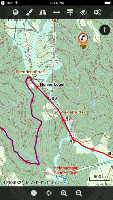


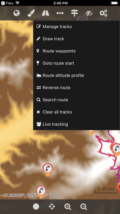
What is Cartograph 2 Maps? The Cartograph app is a mapping application that supports viewing Mapsforge offline vector maps, offline raster maps, and online/WMS maps. It has features such as tracking, route search, overlays, hillshading, reliefs, track drawing, and more. The app is available in multiple languages and supports various map formats.
1. The Cartograph app views Mapsforge offline vector maps, offline raster maps, and online/WMS maps.
2. - View Mapsforge offline vector maps (including v5 format).
3. - Offline raster maps: Locus SQLite maps, MBTiles, TwoWays/CompeGPS RMAP*, Oruxmaps SQLite*.
4. - Support for Mapsforge POIs, offline POI search, and dynamic POI loading.
5. - Map import: iOS 11 File Browser, Wifi upload, iTunes file sharing, internal download manager, and import using "Open in" from 3rd party apps like Safari, Chrome, DropBox, etc.
6. - Import Google Maps POIs/Places using Google Takeout data export function.
7. - Full support for Mapsforge styling/render themes (including hillshading) and layers.
8. - Supports Mapsforge multi-language maps and POIs.
9. - Online map support (including WMS - Web Map Service maps), e.g. OpenStreetMap, OpenCycleMap, OpenSeaMap, WikiMedia hillshading, etc.
10. - Support for Mapsforge multi-maps (multiple .map files stitched into a single map).
11. It supports tracking, route search, overlays, hillshading, reliefs, track drawing, and has many other features.
12. Liked Cartograph 2 Maps? here are 5 Navigation apps like Wheelmap; Trucker Path: Truck GPS & Maps; Argentina Map; New York Subway MTA Map; Droppath Route Planner & Map;
Or follow the guide below to use on PC:
Select Windows version:
Install Cartograph 2 Maps app on your Windows in 4 steps below:
Download a Compatible APK for PC
| Download | Developer | Rating | Current version |
|---|---|---|---|
| Get APK for PC → | Harald Meyer | 3.83 | 2.8.1 |
Get Cartograph 2 Maps on Apple macOS
| Download | Developer | Reviews | Rating |
|---|---|---|---|
| Get $4.99 on Mac | Harald Meyer | 6 | 3.83 |
Download on Android: Download Android
- Supports multiple user interface languages
- Views Mapsforge offline vector maps (including v5 format)
- Full support for Mapsforge styling/render themes (including hillshading) and layers
- Offline raster maps: Locus SQLite maps, MBTiles, TwoWays/CompeGPS RMAP*, Oruxmaps SQLite*
- Online map support (including WMS - Web Map Service maps), e.g. OpenStreetMap, OpenCycleMap, OpenSeaMap, WikiMedia hillshading, etc.
- Import online maps easily from files
- Offline hillshading (from HGT elevation data)
- Offline relief shading
- Offline slope maps (experimental)
- Contour lines (Mapsforge maps)
- Worldwide, free offline maps
- Support for Mapsforge multi-maps (multiple .map files stitched into a single map)
- Night/day mode
- GPS Track recording
- Manual track drawing and editing
- GPX import and export (basic KML/KMZ import support)
- Import of photos with EXIF tags as waypoints
- Import of KMZ photo series
- Import Google Maps POIs/Places using Google Takeout data export function
- Upload tracks to Strava.com
- Route altitude profile and elevation/slope visualization
- Online route search
- Live tracking and polling (using custom server, GPSies.com, or Cartograph server)
- Support for Mapsforge POIs, offline POI search, and dynamic POI loading
- Scalable interface (e.g. to increase button sizes)
- Compass
- Units: Celsius, Kelvin, Fahrenheit, metric, imperial, nautic
- Decimal and degree coordinate modes
- Supports Mapsforge multi-language maps and POIs
- Map import: iOS 11 File Browser, Wifi upload, iTunes file sharing, internal download manager, and import using "Open in" from 3rd party apps like Safari, Chrome, DropBox, etc.
- Voice/sound alerts along routes and waypoints (*EXPERIMENTAL*)
- WaterSupply.at drinking water sources
- Customizable user interface color (dark, light, and colors) and size
- 3D map snapshot view for an overview over the current map region
- Offline Map Downloader (https://www.tequnique.com/offlinemapdownloader)
- OpenAndroMaps.org: very good maps for outdoor activities.
 PC Apps