Last Updated by Bist LLC on 2025-04-30
What is i-Boating? This app provides access to CHS marine vector and raster charts and offers route assistance with voice prompts for marine navigation. It allows users to create new boating routes or import existing GPX/KML routes and supports nautical charts course up orientation. The app also includes tide and currents prediction and covers Trent Severn Waterway, including Lake Simcoe.
1. Great Lakes, Trent Severn Waterway, Ontario Lakes), Atlantic coast derived from CHS data.
2. √ Long press to query the details of Marine object (Buoy, Lights, Obstruction etc).
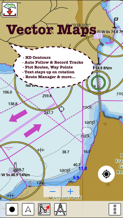
3. This App offers access to CHS marine vector & raster charts.
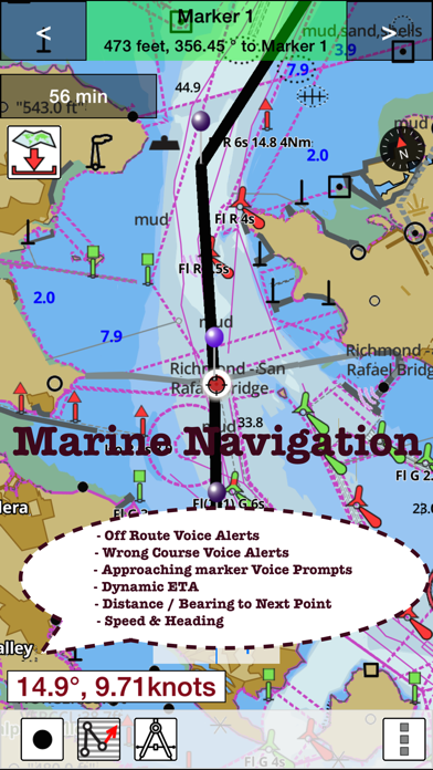
4. First marine GPS app to have route assistance with Voice Prompts for marine navigation.
5. The maps include coverage of Pacific Coast, Central Canada(incl.
6. (Includes coverage for Trent Severn Waterway incl.
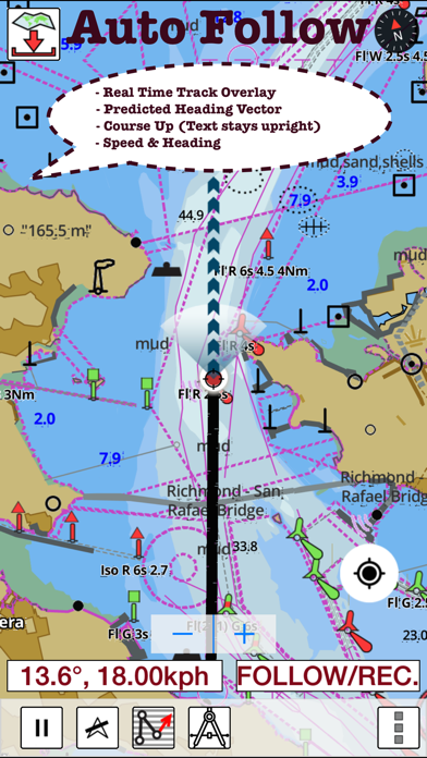
7. √ Record tracks, Autofollow with real-time track overlay & predicted path vector.
8. You can create new boating routes or import existing GPX/KML routes.
9. √ Supports GPX/KML for boating route editing/import.
10. √ 1ft / 3ft depth contour maps for anglers for selected lake maps.
11. Battery Disclaimer: Continued use of GPS running in the background can dramatically decrease battery life.
12. Liked i-Boating? here are 5 Navigation apps like i-Boating: Marine Charts & Gps; Aqua Map Boating; Argo - Boating Navigation; Savvy Navvy Boating Navigation; Wavve Boating: Marine Boat GPS;
Or follow the guide below to use on PC:
Select Windows version:
Install i-Boating: Canada & USA - Marine / Nautical Navigation Charts for fishing & sailing app on your Windows in 4 steps below:
Download a Compatible APK for PC
| Download | Developer | Rating | Current version |
|---|---|---|---|
| Get APK for PC → | Bist LLC | 4.11 | 60.0.0 |
Download on Android: Download Android
- Beautiful and detailed hardware/GPU accelerated vector charts
- Long press to query the details of marine objects
- Customizable depth and distance units
- Customizable shallow depth
- Record tracks, autofollow with real-time track overlay and predicted path vector
- Voice prompts for marine navigation
- 1ft/3ft depth contour maps for anglers for selected lake maps
- Supports GPX/KML for boating route editing/import
- Tide and currents prediction
- Seamless chart quilting of marine charts
- Enter or import waypoints
- Route management/trip planning
- GPS features such as auto follow, route assistance with voice prompts, and record tracks
- Tide and currents information for US, Canada, UK, Germany, and New Zealand
- Marine AIS and NMEA AIS and GPS over TCP/UDP
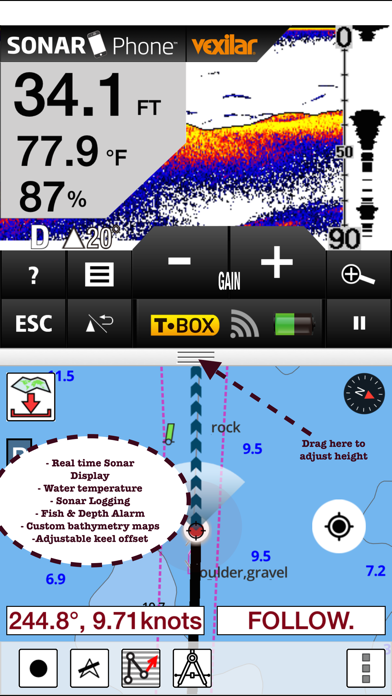
- Wind direction and speed, sonar depth, and water temperature instrumentation
- Sharing options to share tracks/routes/markers on Facebook and Twitter and export them as compressed GPX files
- Sample nautical charts covering various regions and lakes in Canada
- Battery disclaimer: Continued use of GPS running in the background can dramatically decrease battery life.
 PC Apps