
Được viết bởi NesTides
1. above entrance,Allston Creek,Oaks Creek, upper end,Litchfield Beach bridge,Midway Inlet North, Pawleys Island,Bennet's Dock, Pawleys Island Creek,Pawleys Island Pier (ocean),Ward's Dock, Pawleys Inlet,Clambank Creek, Goat Island, North Inlet,Intracoastal Waterway,Little River (town),Nixon Crossroads,Myrtle Beach Airport,North Myrtle Beach, ICWW,Myrtle Beach, Combination Bridge,Socastee Bridge,Winyah Bay,Winyah Bay Entrance (South Jetty),Georgetown Lighthouse,South Island Plantation (C.G. Station),South Island Ferry, Intracoastal Waterway,Frazier Point,Sampit River,Georgetown,Jacobs Wharf,Cumberland,Great Pee Dee River,Windsor Plantation, Black River,Black River (south of Dunbar),Winea Plantation, Black River,Mt.
2. bridge,Grahamville,North Santee River Inlet,Cedar Island, North Santee Bay,Minim Creek ent., ICWW, North Santee Bay,North Santee Bridge,Cedar Island Point,Calibogue Cay, Broad Creek, Hilton Head Island,Broad Creek, Hilton Head Island,Haig Point, Daufuskie Island, Cooper River,Bull Creek, Bull Island South, Cooper River,Pine Island, Ramshorn Creek, Cooper River,Savage I., Savage Creek, Bull Creek,New River,Bloody Point, Daufuskie Island,Hargray Pier, Daufuskie Island,Daufuskie Landing, Daufuskie Island,Doughboy Island,Good Hope Landing, south of,Cook Landing Cemetery,Rt.
3. Pleasant Plantation, Black River,Rhems, Black Mingo Creek, Black River,Weymouth Plantation,Carr Creek, 1 mile above entrance,South of Sam Worth Game Management Area,Arundel Plantation,Holly Grove Plantation,Lower Topsaw Landing,Yauhannah Bridge,Waccamaw River,Waccamaw River Entrance,Hagley Landing,Thoroughfare Creek entrance,Wachesaw Landing,Bull Creek entrance,Little Bull Creek entrance, Bull Creek,Bucksport,Enterprise Landing,Keysfield,Pitch Landing,Conway, RR.
4. Dunn Sound, Little River Inlet,Dunn Sound, north end,Dunn Sound, west end,Little River Neck, north end,Cherry Grove (inside),Hog Inlet Pier,MYRTLE BEACH, SPRINGMAID PIER,Garden City Pier (ocean),Murrells Inlet,Garden City Bridge, Main Creek,Divine's Dock,Smith's Dock,Captain Alex's Marina, Parsonage Creek,Oaks Creek, 0.5 mi.
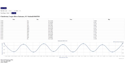
5. Advanced tide graphs allow for you to judge the level of water movement for optimal fishing between high and low tide in South Carolina between tide stations so you can follow the tide flow for the entire day.
6. Ability to forecast South Carolina tides from NOAA by setting date and period for any of the tidal stations for the entire State of South Carolina tide tables.
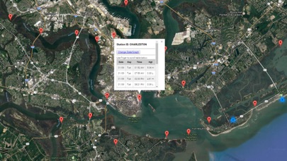
7. Accurate, simple to use Satellite Map based South Carolina tide charts of the all NOAA based South Carolina tide stations on a simple to use satellite map.
8. "NesTides ability to display tide predictions and actual tidal flow graphs allow me to extend fishing trips by following different tide station tide charts and moving with the tide flow.
9. Included is the ability to zoom and view satellite imagery for fishing ground characteristics to compare with tide movement.
10. Designed by South Carolina fishermen and Professional South Carolina Fishing Guides.
11. Auto-save last location for easy reference to your last tide station the next time you use the tide app.
Kiểm tra Ứng dụng / Ứng dụng thay thế PC tương thích
| Ứng dụng | Tải về | Xếp hạng | Nhà phát triển |
|---|---|---|---|
|
South Carolina Tide Chart
|
Tải ứng dụng ↲ | 1 1.00
|
NesTides |
Hoặc làm theo hướng dẫn dưới đây để sử dụng trên PC :
messages.choose_pc:
Yêu cầu Cài đặt Phần mềm:
Có sẵn để tải xuống trực tiếp. Tải xuống bên dưới:
Bây giờ, mở ứng dụng Trình giả lập bạn đã cài đặt và tìm kiếm thanh tìm kiếm của nó. Một khi bạn tìm thấy nó, gõ South Carolina Tide Chart trong thanh tìm kiếm và nhấn Tìm kiếm. Bấm vào South Carolina Tide Chartbiểu tượng ứng dụng. Một cửa sổ South Carolina Tide Chart trên Cửa hàng Play hoặc cửa hàng ứng dụng sẽ mở và nó sẽ hiển thị Cửa hàng trong ứng dụng trình giả lập của bạn. Bây giờ nhấn nút Tải xuống và, như trên thiết bị iPhone hoặc Android của bạn, ứng dụng của bạn sẽ bắt đầu tải xuống. Bây giờ chúng ta đã xong.
Bạn sẽ thấy một biểu tượng có tên "Tất cả ứng dụng".
Click vào nó và nó sẽ đưa bạn đến một trang chứa tất cả các ứng dụng đã cài đặt của bạn.
Bạn sẽ thấy biểu tượng. Click vào nó và bắt đầu sử dụng ứng dụng.
Nhận APK tương thích cho PC
| Tải về | Nhà phát triển | Xếp hạng | Phiên bản hiện tại |
|---|---|---|---|
| Tải về APK dành cho PC » | NesTides | 1.00 | 1.0 |
Tải về South Carolina Tide Chart cho Mac OS (Apple)
| Tải về | Nhà phát triển | Bài đánh giá | Xếp hạng |
|---|---|---|---|
| $9.99 cho Mac OS | NesTides | 1 | 1.00 |

Florida Tides & Fishing Regs

Gulf of Mexico Tide Tables

Southeastern Tidal Times

Chesapeake - Tidewater Tides

Northeast U.S.A. Tide Tables

Weather Live°

Weather - Weather forecast
Barometer Plus

Windy.com

IQAir AirVisual | Air Quality

Thermometer++

Real Thermometer

Weather: UK
Weather ·

Weather: Forecast & Radar Live

Tide Charts Near Me
Clime: Weather Radar Live

WEATHER NOW daily forecast app

CARROT Weather

Lịch thủy triều - mồi câu cá
 PcMac Việt