
投稿者 NesTides
1. above entrance,Allston Creek,Oaks Creek, upper end,Litchfield Beach bridge,Midway Inlet North, Pawleys Island,Bennet's Dock, Pawleys Island Creek,Pawleys Island Pier (ocean),Ward's Dock, Pawleys Inlet,Clambank Creek, Goat Island, North Inlet,Intracoastal Waterway,Little River (town),Nixon Crossroads,Myrtle Beach Airport,North Myrtle Beach, ICWW,Myrtle Beach, Combination Bridge,Socastee Bridge,Winyah Bay,Winyah Bay Entrance (South Jetty),Georgetown Lighthouse,South Island Plantation (C.G. Station),South Island Ferry, Intracoastal Waterway,Frazier Point,Sampit River,Georgetown,Jacobs Wharf,Cumberland,Great Pee Dee River,Windsor Plantation, Black River,Black River (south of Dunbar),Winea Plantation, Black River,Mt.
2. bridge,Grahamville,North Santee River Inlet,Cedar Island, North Santee Bay,Minim Creek ent., ICWW, North Santee Bay,North Santee Bridge,Cedar Island Point,Calibogue Cay, Broad Creek, Hilton Head Island,Broad Creek, Hilton Head Island,Haig Point, Daufuskie Island, Cooper River,Bull Creek, Bull Island South, Cooper River,Pine Island, Ramshorn Creek, Cooper River,Savage I., Savage Creek, Bull Creek,New River,Bloody Point, Daufuskie Island,Hargray Pier, Daufuskie Island,Daufuskie Landing, Daufuskie Island,Doughboy Island,Good Hope Landing, south of,Cook Landing Cemetery,Rt.
3. Pleasant Plantation, Black River,Rhems, Black Mingo Creek, Black River,Weymouth Plantation,Carr Creek, 1 mile above entrance,South of Sam Worth Game Management Area,Arundel Plantation,Holly Grove Plantation,Lower Topsaw Landing,Yauhannah Bridge,Waccamaw River,Waccamaw River Entrance,Hagley Landing,Thoroughfare Creek entrance,Wachesaw Landing,Bull Creek entrance,Little Bull Creek entrance, Bull Creek,Bucksport,Enterprise Landing,Keysfield,Pitch Landing,Conway, RR.
4. Dunn Sound, Little River Inlet,Dunn Sound, north end,Dunn Sound, west end,Little River Neck, north end,Cherry Grove (inside),Hog Inlet Pier,MYRTLE BEACH, SPRINGMAID PIER,Garden City Pier (ocean),Murrells Inlet,Garden City Bridge, Main Creek,Divine's Dock,Smith's Dock,Captain Alex's Marina, Parsonage Creek,Oaks Creek, 0.5 mi.
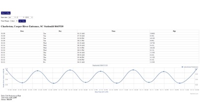
5. Advanced tide graphs allow for you to judge the level of water movement for optimal fishing between high and low tide in South Carolina between tide stations so you can follow the tide flow for the entire day.
6. Ability to forecast South Carolina tides from NOAA by setting date and period for any of the tidal stations for the entire State of South Carolina tide tables.
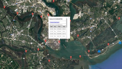
7. Accurate, simple to use Satellite Map based South Carolina tide charts of the all NOAA based South Carolina tide stations on a simple to use satellite map.
8. "NesTides ability to display tide predictions and actual tidal flow graphs allow me to extend fishing trips by following different tide station tide charts and moving with the tide flow.
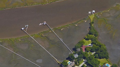
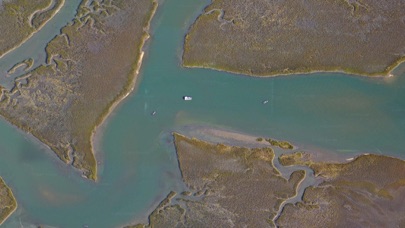
9. Included is the ability to zoom and view satellite imagery for fishing ground characteristics to compare with tide movement.
10. Designed by South Carolina fishermen and Professional South Carolina Fishing Guides.
11. Auto-save last location for easy reference to your last tide station the next time you use the tide app.
または、以下のガイドに従ってPCで使用します :
PCのバージョンを選択してください:
ソフトウェアのインストール要件:
直接ダウンロードできます。以下からダウンロード:
これで、インストールしたエミュレータアプリケーションを開き、検索バーを探します。 一度それを見つけたら、 South Carolina Tide Chart を検索バーに入力し、[検索]を押します。 クリック South Carolina Tide Chartアプリケーションアイコン。 のウィンドウ。 South Carolina Tide Chart - Playストアまたはアプリストアのエミュレータアプリケーションにストアが表示されます。 Installボタンを押して、iPhoneまたはAndroidデバイスのように、アプリケーションのダウンロードが開始されます。 今私達はすべて終わった。
「すべてのアプリ」というアイコンが表示されます。
をクリックすると、インストールされているすべてのアプリケーションを含むページが表示されます。
あなたは アイコン。 それをクリックし、アプリケーションの使用を開始します。
ダウンロード South Carolina Tide Chart Mac OSの場合 (Apple)
| ダウンロード | 開発者 | レビュー | 評価 |
|---|---|---|---|
| $9.99 Mac OSの場合 | NesTides | 1 | 1.00 |

Florida Tides & Fishing Regs

Gulf of Mexico Tide Tables

Southeastern Tidal Times

Chesapeake - Tidewater Tides

Northeast U.S.A. Tide Tables

ウェザーニュース

Yahoo!天気

頭痛ーる

tenki.jp -日本気象協会の天気予報専門アプリ-

Yahoo!防災速報

Windy.com

特務機関NERV防災

タイドグラフBI /全国の釣り場ごとの潮見表

真の温度計
温度計++
湿度計

ゆれくるコール

Windy.app: 天気予報 - 風予報、風速

アメフリ

アメミル
 PcMac 日本語