
Publié par NesTides
1. above entrance,Allston Creek,Oaks Creek, upper end,Litchfield Beach bridge,Midway Inlet North, Pawleys Island,Bennet's Dock, Pawleys Island Creek,Pawleys Island Pier (ocean),Ward's Dock, Pawleys Inlet,Clambank Creek, Goat Island, North Inlet,Intracoastal Waterway,Little River (town),Nixon Crossroads,Myrtle Beach Airport,North Myrtle Beach, ICWW,Myrtle Beach, Combination Bridge,Socastee Bridge,Winyah Bay,Winyah Bay Entrance (South Jetty),Georgetown Lighthouse,South Island Plantation (C.G. Station),South Island Ferry, Intracoastal Waterway,Frazier Point,Sampit River,Georgetown,Jacobs Wharf,Cumberland,Great Pee Dee River,Windsor Plantation, Black River,Black River (south of Dunbar),Winea Plantation, Black River,Mt.
2. bridge,Grahamville,North Santee River Inlet,Cedar Island, North Santee Bay,Minim Creek ent., ICWW, North Santee Bay,North Santee Bridge,Cedar Island Point,Calibogue Cay, Broad Creek, Hilton Head Island,Broad Creek, Hilton Head Island,Haig Point, Daufuskie Island, Cooper River,Bull Creek, Bull Island South, Cooper River,Pine Island, Ramshorn Creek, Cooper River,Savage I., Savage Creek, Bull Creek,New River,Bloody Point, Daufuskie Island,Hargray Pier, Daufuskie Island,Daufuskie Landing, Daufuskie Island,Doughboy Island,Good Hope Landing, south of,Cook Landing Cemetery,Rt.
3. Pleasant Plantation, Black River,Rhems, Black Mingo Creek, Black River,Weymouth Plantation,Carr Creek, 1 mile above entrance,South of Sam Worth Game Management Area,Arundel Plantation,Holly Grove Plantation,Lower Topsaw Landing,Yauhannah Bridge,Waccamaw River,Waccamaw River Entrance,Hagley Landing,Thoroughfare Creek entrance,Wachesaw Landing,Bull Creek entrance,Little Bull Creek entrance, Bull Creek,Bucksport,Enterprise Landing,Keysfield,Pitch Landing,Conway, RR.
4. Dunn Sound, Little River Inlet,Dunn Sound, north end,Dunn Sound, west end,Little River Neck, north end,Cherry Grove (inside),Hog Inlet Pier,MYRTLE BEACH, SPRINGMAID PIER,Garden City Pier (ocean),Murrells Inlet,Garden City Bridge, Main Creek,Divine's Dock,Smith's Dock,Captain Alex's Marina, Parsonage Creek,Oaks Creek, 0.5 mi.
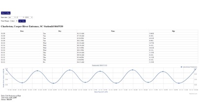
5. Advanced tide graphs allow for you to judge the level of water movement for optimal fishing between high and low tide in South Carolina between tide stations so you can follow the tide flow for the entire day.
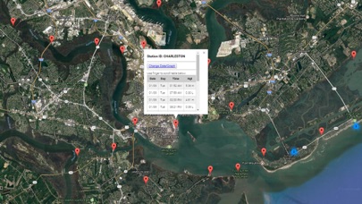
6. Ability to forecast South Carolina tides from NOAA by setting date and period for any of the tidal stations for the entire State of South Carolina tide tables.
7. Accurate, simple to use Satellite Map based South Carolina tide charts of the all NOAA based South Carolina tide stations on a simple to use satellite map.
8. "NesTides ability to display tide predictions and actual tidal flow graphs allow me to extend fishing trips by following different tide station tide charts and moving with the tide flow.
9. Included is the ability to zoom and view satellite imagery for fishing ground characteristics to compare with tide movement.
10. Designed by South Carolina fishermen and Professional South Carolina Fishing Guides.
11. Auto-save last location for easy reference to your last tide station the next time you use the tide app.
Vérifier les applications ou alternatives PC compatibles
| App | Télécharger | Évaluation | Écrit par |
|---|---|---|---|
|
South Carolina Tide Chart
|
Obtenir une application ou des alternatives ↲ | 1 1.00
|
NesTides |
Ou suivez le guide ci-dessous pour l'utiliser sur PC :
Choisissez votre version PC:
Configuration requise pour l'installation du logiciel:
Disponible pour téléchargement direct. Téléchargez ci-dessous:
Maintenant, ouvrez l'application Emulator que vous avez installée et cherchez sa barre de recherche. Une fois que vous l'avez trouvé, tapez South Carolina Tide Chart dans la barre de recherche et appuyez sur Rechercher. Clique sur le South Carolina Tide Chartnom de l'application. Une fenêtre du South Carolina Tide Chart sur le Play Store ou le magasin d`applications ouvrira et affichera le Store dans votre application d`émulation. Maintenant, appuyez sur le bouton Installer et, comme sur un iPhone ou un appareil Android, votre application commencera à télécharger. Maintenant nous avons tous fini.
Vous verrez une icône appelée "Toutes les applications".
Cliquez dessus et il vous mènera à une page contenant toutes vos applications installées.
Tu devrais voir le icône. Cliquez dessus et commencez à utiliser l'application.
Obtenir un APK compatible pour PC
| Télécharger | Écrit par | Évaluation | Version actuelle |
|---|---|---|---|
| Télécharger APK pour PC » | NesTides | 1.00 | 1.0 |
Télécharger South Carolina Tide Chart pour Mac OS (Apple)
| Télécharger | Écrit par | Critiques | Évaluation |
|---|---|---|---|
| $9.99 pour Mac OS | NesTides | 1 | 1.00 |

Florida Tides & Fishing Regs

Gulf of Mexico Tide Tables

Southeastern Tidal Times

Chesapeake - Tidewater Tides

Northeast U.S.A. Tide Tables

Météo & Radar

Thermomètre réel

YoWindow Météo
RainToday

Météo-France

Thermomètre º

YoWindow, une météo précise

La Chaîne Météo

La météo agricole

Windy.com

SimClimat
Meteociel

Température de chambre

Skiinfo

Météo Live: Prévisions Locales
 PcMac Français