에 의해 게시 Bist LLC
1. This App offers offline nautical charts, lake & river navigation maps covering Netherlands/Holland (derived from NLHO data) for fishing, kayaking, boating and sailing.
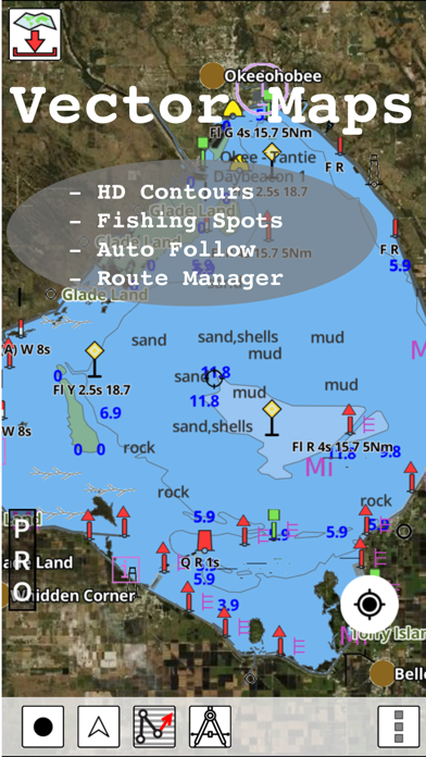
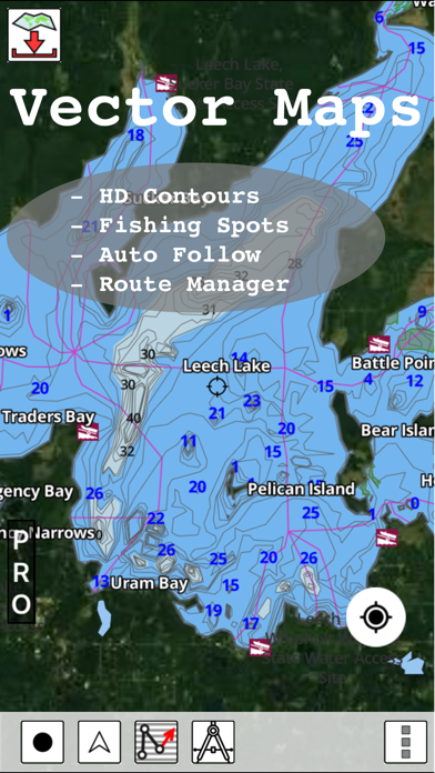
2. Coverage includes marine vector charts, freshwater lake maps, and inland river maps (HD/1ft/3ft bathymetry included where available).
3. First marine GPS app to have route assistance with Voice Prompts for marine navigation.
4. √ 1ft / 3ft depth contour maps for anglers for selected lake maps.
5. √ Query details of Marine object (Buoy, Lights, Obstruction etc).
6. You can create new boating routes or import existing GPX/KML routes.
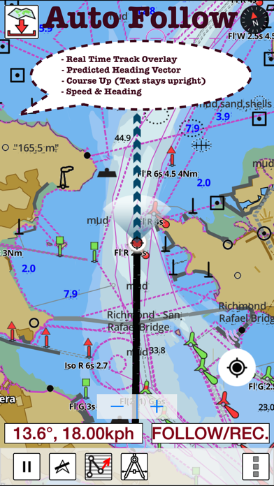
7. √ Record tracks, Autofollow with real-time track overlay & predicted path vector.
8. √ Supports GPX/KML for boating route editing/import.
9. It supports Nautical Charts course up orientation.
10. Netherlands:Marine ENC & Inland ENC (derived from NLHO data).
11. Includes Tide & Currents prediction.

또는 아래 가이드를 따라 PC에서 사용하십시오. :
PC 버전 선택:
소프트웨어 설치 요구 사항:
직접 다운로드 가능합니다. 아래 다운로드 :
설치 한 에뮬레이터 애플리케이션을 열고 검색 창을 찾으십시오. 일단 찾았 으면 i-Boating:Holland/Netherlands 검색 막대에서 검색을 누릅니다. 클릭 i-Boating:Holland/Netherlands응용 프로그램 아이콘. 의 창 i-Boating:Holland/Netherlands Play 스토어 또는 앱 스토어의 스토어가 열리면 에뮬레이터 애플리케이션에 스토어가 표시됩니다. Install 버튼을 누르면 iPhone 또는 Android 기기 에서처럼 애플리케이션이 다운로드되기 시작합니다. 이제 우리는 모두 끝났습니다.
"모든 앱 "아이콘이 표시됩니다.
클릭하면 설치된 모든 응용 프로그램이 포함 된 페이지로 이동합니다.
당신은 아이콘을 클릭하십시오. 그것을 클릭하고 응용 프로그램 사용을 시작하십시오.
다운로드 i-Boating Mac OS의 경우 (Apple)
| 다운로드 | 개발자 | 리뷰 | 평점 |
|---|---|---|---|
| $34.99 Mac OS의 경우 | Bist LLC | 0 | 1 |
This App offers offline nautical charts, lake & river navigation maps covering Netherlands/Holland (derived from NLHO data) for fishing, kayaking, boating and sailing. Coverage includes marine vector charts, freshwater lake maps, and inland river maps (HD/1ft/3ft bathymetry included where available). First marine GPS app to have route assistance with Voice Prompts for marine navigation. You can create new boating routes or import existing GPX/KML routes. It supports Nautical Charts course up orientation. Includes Tide & Currents prediction. ►FEATURES √ Beautiful and detailed Hardware/GPU accelerated vector charts (text stays upright on rotation) √ Query details of Marine object (Buoy, Lights, Obstruction etc). √ Customizable depth(Ft/Fathom/Meter) and distance units (km/mi/NM) √ Customizable Shallow Depth. √ Record tracks, Autofollow with real-time track overlay & predicted path vector. √ Voice Prompts for marine navigation (requires GPS ) √ 1ft / 3ft depth contour maps for anglers for selected lake maps. √ Supports GPX/KML for boating route editing/import. √ Tide & Currents prediction. √ Seamless chart quilting. Map details from Coastal, Approaches,Harbour, Inland Encs(rivers), and general ENC charts are automatically mapped to correct zoomlevel √ Enter or import Waypoints. ► MAPS Get all the details that you find in your chart plotters! (More regions are added every week) Please check website. Includes unlimited updates for 1 year. Netherlands:Marine ENC & Inland ENC (derived from NLHO data). ►ROUTE MANAGEMENT / TRIP PLANNING √ Create New Route/Edit Routes √ Reverse Routes √ Enter,Move, Add, Delete, Rename Waypoints √ Import GPX, KML & KMZ files √ Plot/Edit Routes √ Share/Export Routes, Tracks & Markers ►GPS FEATURES √ Auto Follow * Real Time Track Overlay * Predicted Path Vector * Course Up (Text stays upright) * Speed & Heading √ Route Assistance With Voice Prompts * Prompts when approaching a boating route marker * Continous distance & ETA updates * Alerts when sailing/boating off route * Alerts when boating in wrong direction √ Record Tracks ►TIDE & CURRENTS * For US, Canada, UK,Germany&New Zealand * High/Low Tides * Tidal Current Prediction * Active Current Stations ► SHARING * Share tracks/routes/markers on Facebook & Twitter * Export tracks/routes/markers as compressed GPX files. Sample Charts IJsselmeer Markermeer Den Helder Zeegat van Texel Noordzeekust Nieuwpoort Oostende Panne-Oostend Blankenberge Zeebrugge Oostende-Westkap Breskens Vlissingen Westerschelde. Vlissingen Neeltje Jans Stellendam Schouwen-Ho Scheveningen Hoek van Holland IJmuiden Noordwijk IJmuiden Zeeuwse Breskens Vlissingen Cadzand-Borssele Hansweert Terneuzen Borssele-kruini Walsoorden Bath-Lillo Doel-Antwerpen Terneuzen Walcheren-Vlissingen Bergen Tholen Zoommeer.Thol Colijnsplaat Zierikzee Burghsluis Oosterschelde. Zeeuwse en Zuid Ho Veere Oranjeplaat Omloop Kamperland Oostwatering Veerse Meer Westelijk gedeelte Kortgene Wolphaartsdijk Zandkreeksluis Veerse Meer Oostelijk gedeelte Zuid Beveland. Wemeldi Goessche Sas Stavenisse Zeelandbrug Bruinisse St. Annaland Oosterschelde. Keeten Krammer Kr Yerseke Oosterschelde. Yerseke Bergsed Ouddorp Scharendijke Brouwershaven Den Osse Grevelingenmeer Westelijke Zijde Bruinisse Battenoord Herkingen Grevelingenmeer Oostelijke Zijde Overzichtskaart Zeeuwse en Zuid Ho Bergen op Zoom Tholen Zoommeer. Kreekraksluizen Thol Schelde-Rijnverbinding. Tholense b Galathese Haven Benedensas Dintelsas Ooltgensplaat Oude Tonge Volkerak. Krammersluizen Volke Goudswaard Nieuw Beijerland Zuidland Spui. Middelharnis Hellevoetsluis Middelharnis Haringvliet. Stad aan 't Haringvliet Den Bommel Hitsertse Kade Nieuwendijk Haringvliet oost Willemstad Noordschans Moerdijk Strijensas Dordtse Kil. Moerdijk Strijensas Dordtsche Brielse Meer. Brielsebrug Brie Zeeuwse en Zuid Nieuwe waterweg. Hoek van Holland Nieuwe waterweg. Maassluis Nieuwe Waterweg. Rotterdam Centrum

Marine Navigation-USA Lake Map

Marine Navigation - Canada

i-Boating Spain: Marine Charts

South Africa: Marine Navigation Charts & Boat Maps

i-Boating: Malta Marine Charts

네이버 지도, 내비게이션

카카오맵 - 대한민국 No.1 지도앱

TMAP - 내비게이션 / 지도

카카오버스
Google Maps

카카오내비

오일나우 - 유류세 인하 실시간 반영 중

카카오지하철

전국 스마트 버스 - 실시간 버스, 길찾기

지맵(Z-MAP)-제로페이, 가맹점 찾기, 모바일상품권

지하철 - 실시간 열차정보

모두의주차장 - 주차장찾기/주차할인/공유주차장

스마터치- 교통카드 필수 앱!

전국 시외버스 승차권 통합 예매(버스타고)

지하철 종결자 : Smarter Subway
 PcMac 한국어