
에 의해 게시 Bist LLC
1. GPS Marine Charts App offers access to charts covering Spain waters (derived from IHM ( Instituto Hidrográfico de la Marina)data).
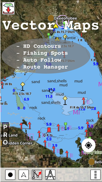
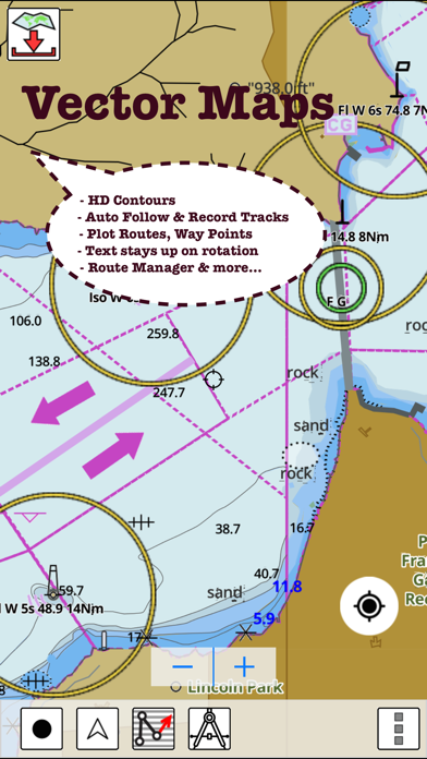
2. - POI list derived from the equivalent ENC and contains all categories including Buoy, Light, Harbour facility, Obstr.
3. It has route manager to create new boating routes or import existing GPX/KML routes.
4. Only marine GPS app to have route assistance with Voice Prompts for marine navigation.
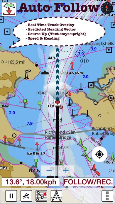
5. It supports Nautical Charts course up orientation.
6. PLEASE NOTE: Continued use of GPS running in the background can dramatically decrease battery life.
7. for complete list.
또는 아래 가이드를 따라 PC에서 사용하십시오. :
PC 버전 선택:
소프트웨어 설치 요구 사항:
직접 다운로드 가능합니다. 아래 다운로드 :
설치 한 에뮬레이터 애플리케이션을 열고 검색 창을 찾으십시오. 일단 찾았 으면 i-Boating Spain: Marine Charts 검색 막대에서 검색을 누릅니다. 클릭 i-Boating Spain: Marine Charts응용 프로그램 아이콘. 의 창 i-Boating Spain: Marine Charts Play 스토어 또는 앱 스토어의 스토어가 열리면 에뮬레이터 애플리케이션에 스토어가 표시됩니다. Install 버튼을 누르면 iPhone 또는 Android 기기 에서처럼 애플리케이션이 다운로드되기 시작합니다. 이제 우리는 모두 끝났습니다.
"모든 앱 "아이콘이 표시됩니다.
클릭하면 설치된 모든 응용 프로그램이 포함 된 페이지로 이동합니다.
당신은 아이콘을 클릭하십시오. 그것을 클릭하고 응용 프로그램 사용을 시작하십시오.
다운로드 i-Boating Spain Mac OS의 경우 (Apple)
| 다운로드 | 개발자 | 리뷰 | 평점 |
|---|---|---|---|
| $29.99 Mac OS의 경우 | Bist LLC | 1 | 5.00 |
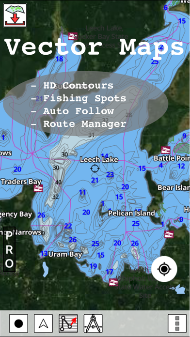
GPS Marine Charts App offers access to charts covering Spain waters (derived from IHM ( Instituto Hidrográfico de la Marina)data). Only marine GPS app to have route assistance with Voice Prompts for marine navigation. It has route manager to create new boating routes or import existing GPX/KML routes. It supports Nautical Charts course up orientation. Please visit http://gpsnauticalcharts.com/main/spain/all-all-spain-charts-nautical-charts-folio.html for complete list. If you don't find the chart for Spain , please contact us at support at gpsnauticalcharts.com. * Voice Prompts for marine navigation (requires GPS ) -prompts when approaching a boating route marker -Continous distance and ETA updates -Alerts when sailing/boating off route -Alerts when boating in wrong direction *Route Editing/Creation -Create routes from scratch -Edit existing GPX/KML routes. -Add custom description to any route point. -Drop markers along route. * Offline charts derived from IHM data. -Visually draw area to download -Textual search -Catalog -Charts reprojected for WGS84 datum *Seamless chart quilting of marine charts *Distance Bearing tool *Create custom way points - Using GPS -Select point on map -Manually enter latitude & longitude coordinates *POI layer for marine charts - Overlay POIs - POI list derived from the equivalent ENC and contains all categories including Buoy, Light, Harbour facility, Obstr. *Search POIs/Way points *Pan/Zoom/My Location * Record Marine GPS tracks * View tracks overlay * Live track animation * Track analytics/stats * Export GPX tracks. -Export to SDCard -Share GPX trakcs with friends. * Auto Follow Mode (Course up) -Continuously updates boat's location on chart - Adjustable update frequency Sample Nautical Charts Tanger-Mediterranee Baie de Fontarabie or Rada de Higuer Channels Between Ibiza and Formentera Denia ADRA Ensenada de San Simon Algeciras Alicante Almeria Luarca Pobla de Farnals Alicante Barcelona Bilbao Cartagena Gijon Malaga Palma Ria de Arousa Valencia Ria de Corme y Laxe Rio Guadalquivir Santa Uxia de Ribeira Bahia de Cadiz Pobra do Caraminal San Sebastian and Pasaia (Pasajes) Barcelona Barcelona to Napoli including Islas Baleares Corse and Sardegna Bay of Biscay Garrucha Bilbao Port Saplaya Ria de Camarinas BSan Esteban de Pravia Cabo de San Antonio to Vilanova i la Geltru including Islas de Ibiza and Formentera Cabo de San Lorenzo to Cabo Ortegal Cabo de Santa Maria to Cabo Trafalgar Cabo de Sao Vicente to the Strait of Gibraltar Cabo Finisterre to the Strait of Gibraltar Cabo San Sebastian to Iles d'Hyeres Cabo Torinana to Punta Carreiro Cadiz Aguilas and El Hornillo Cartagena Castellon Castro Urdiales Ceuta Getaria Melilla and Port Nador Ria de Navia Vilanova de Arousa and San Xulian de Arousa Melilla and Port Nador Cambados and San Martin de o Grove Ondarroa Eastern to the Strait of Gibraltar E Barra Del Rio Guadalquivir Carboneras Lekeitio Ensenada de San Ciprian Elantxobe and Lekeitio Gandia Elantxobe Gibraltar Bay Gijon Ria de Santona Ibiza- Formentera and Southern Mallorca Isla de Alboran Islas Sisargas to Montedor La Coruna and Mahon Malaga Mallorca and Menorca Marin and Pontevedra Menorca Menorca to Sicilia including Malta Mimizan-Plage to Cabo de Ajo MOTRIL Palma Pasaia (Pasajes) Alcudia Carino Ferrol Huelva Puerto de Lastres Puerto de Luanco Ribadesella Bermeo and Mundaka Punta de la Bana to Islas Medas Punta de la Estaca de Bares to Cabo Finisterre Punta Umbria Ras Tarf to Oran Ria de Arousa Ria de Aviles Ria de Cedeira Ria De Ferrol Ria del Barquero Ria de Muros PLEASE NOTE: Continued use of GPS running in the background can dramatically decrease battery life.

Marine Navigation-USA Lake Map

Marine Navigation - Canada
i-Boating Spain: Marine Charts

South Africa: Marine Navigation Charts & Boat Maps

i-Boating: Malta Marine Charts

네이버 지도, 내비게이션

카카오맵 - 대한민국 No.1 지도앱

TMAP - 내비게이션 / 지도

카카오버스
Google Maps

카카오내비

오일나우 - 유류세 인하 실시간 반영 중

카카오지하철

전국 스마트 버스 - 실시간 버스, 길찾기

지맵(Z-MAP)-제로페이, 가맹점 찾기, 모바일상품권

지하철 - 실시간 열차정보

모두의주차장 - 주차장찾기/주차할인/공유주차장

스마터치- 교통카드 필수 앱!

전국 시외버스 승차권 통합 예매(버스타고)

지하철 종결자 : Smarter Subway
 PcMac 한국어