
投稿者 投稿者 NASA
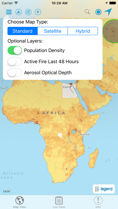
1. Developed by the NASA Socioeconomic Data and Applications Center (SEDAC) operated by the Center for International Earth Science Information Network (CIESIN) at Columbia University, HazPop combines data and map layers from various sources including NASA's Land, Atmosphere Near real-time Capability for EOS (LANCE) and Global Imagery Browse Services (GIBS), the U.S. Geological Survey (USGS), and others using a variety of open Web mapping services.
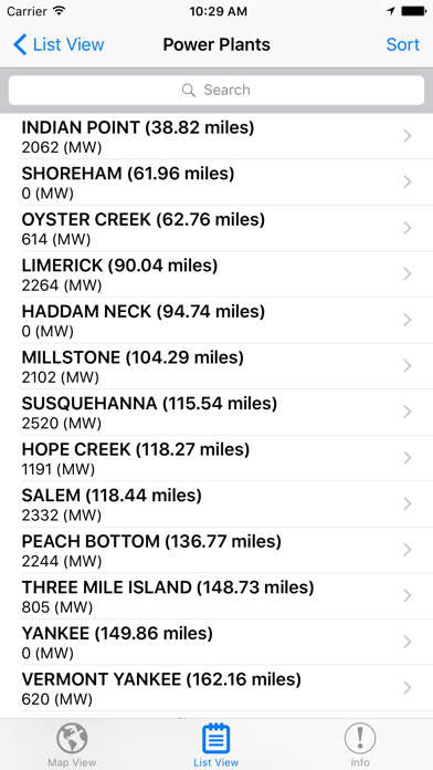
2. HazPop supports a number of other functions including: Monitoring regions around an area of interest, e.g. hazardous area prone to natural disasters, major infrastructure, or densely populated areas; Sorting dams, nuclear power plants, or earthquakes by proximity to your location or by their characteristics; Determining the distance from your location to any point on the map or between any two points on the map.
3. Hazards and Population Mapper (HazPop) is a free app that enables users to easily display recent natural hazard data in relationship to population, major infrastructure, and satellite imagery.
4. HazPop is designed to be used by disaster risk managers, humanitarian response organizations, public health professionals, journalists, and others needing a quick assessment of the potential dangers posed by a major hazardous event or developing emergency.
5. For example, a disaster response agency can obtain a rough estimate of the population and major facilities near a recent earthquake as an input into response planning.
6. The app shows the location of major dams and nuclear power plants and provides more detailed information and imagery for these facilities where available.
7. Due to the coarse resolution and varying quality of some of the data, HazPop is not intended to support in-depth risk assessment or location-specific response needs.
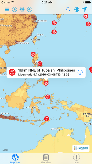
8. Hazards data include the location of active fires over the past 48 hours; earthquake alerts over the past seven days; and yesterday′s air pollution data measured from space.
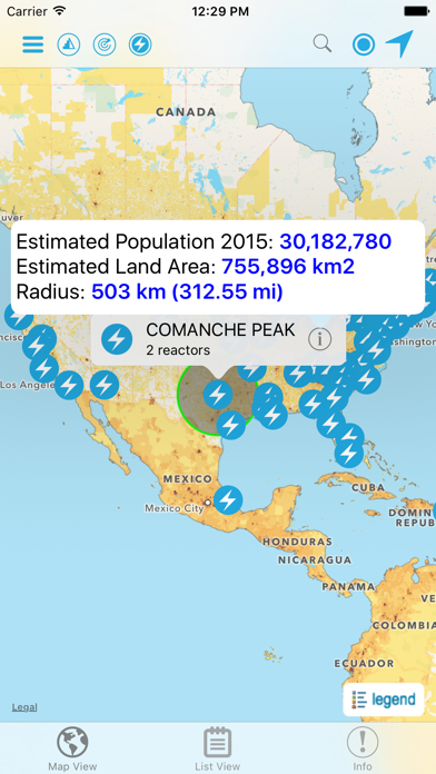
9. By drawing a circle around a point or area of interest on the map, users can obtain an estimate of the total population and land area enclosed within.
10. The custom population estimates are provided by the SEDAC Population Estimation Service (PES) based on SEDAC′s Gridded Population of the World, version 4 (GPWv4) data for 2015.
11. Journalists or students can explore the location of recent wildfires relative to dense populations, roads, terrain, and water bodies.
または、以下のガイドに従ってPCで使用します :
PCのバージョンを選択してください:
ソフトウェアのインストール要件:
直接ダウンロードできます。以下からダウンロード:
これで、インストールしたエミュレータアプリケーションを開き、検索バーを探します。 一度それを見つけたら、 Hazards and Population Mapper を検索バーに入力し、[検索]を押します。 クリック Hazards and Population Mapperアプリケーションアイコン。 のウィンドウ。 Hazards and Population Mapper - Playストアまたはアプリストアのエミュレータアプリケーションにストアが表示されます。 Installボタンを押して、iPhoneまたはAndroidデバイスのように、アプリケーションのダウンロードが開始されます。 今私達はすべて終わった。
「すべてのアプリ」というアイコンが表示されます。
をクリックすると、インストールされているすべてのアプリケーションを含むページが表示されます。
あなたは アイコン。 それをクリックし、アプリケーションの使用を開始します。
ダウンロード Hazards and Population Mapper Mac OSの場合 (Apple)
| ダウンロード | 開発者 | レビュー | 評価 |
|---|---|---|---|
| Free Mac OSの場合 | NASA | 6 | 3.33 |

NASA

NASA Lunar Electric Rover Simulator

iMorpheus

NASA Visualization Explorer

NASA Desert RATS Virtual Test Site
Google 翻訳

KnowMe-AIフェイスエディターとクイズ

Papago - AI通訳・翻訳

翻訳 - 今すぐ翻訳

DeepL翻訳

漢字検索

トリセツ-取扱説明書管理アプリ

英語翻訳機-英文翻訳と英語勉強翻訳辞書

漢字辞典 - 手書き漢字検索アプリ

Weblio英語辞書 - 英和辞典 - 和英辞典を多数掲載

Weblio国語辞典 - 辞書や辞典を多数掲載

U-翻訳&辞書-翻訳機

翻訳王- タップde辞書!OCRスキャンアプリ

韓国語翻訳-韓国語写真音声翻訳アプリ

vpn-快喵vpn
 PcMac 日本語