
写的 - 写的 - NASA
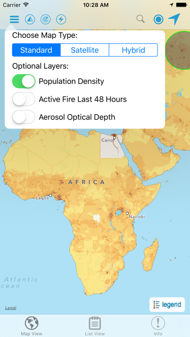
1. Developed by the NASA Socioeconomic Data and Applications Center (SEDAC) operated by the Center for International Earth Science Information Network (CIESIN) at Columbia University, HazPop combines data and map layers from various sources including NASA's Land, Atmosphere Near real-time Capability for EOS (LANCE) and Global Imagery Browse Services (GIBS), the U.S. Geological Survey (USGS), and others using a variety of open Web mapping services.
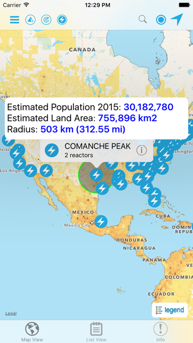
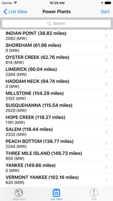
2. HazPop supports a number of other functions including: Monitoring regions around an area of interest, e.g. hazardous area prone to natural disasters, major infrastructure, or densely populated areas; Sorting dams, nuclear power plants, or earthquakes by proximity to your location or by their characteristics; Determining the distance from your location to any point on the map or between any two points on the map.
3. Hazards and Population Mapper (HazPop) is a free app that enables users to easily display recent natural hazard data in relationship to population, major infrastructure, and satellite imagery.
4. HazPop is designed to be used by disaster risk managers, humanitarian response organizations, public health professionals, journalists, and others needing a quick assessment of the potential dangers posed by a major hazardous event or developing emergency.
5. For example, a disaster response agency can obtain a rough estimate of the population and major facilities near a recent earthquake as an input into response planning.
6. The app shows the location of major dams and nuclear power plants and provides more detailed information and imagery for these facilities where available.
7. Due to the coarse resolution and varying quality of some of the data, HazPop is not intended to support in-depth risk assessment or location-specific response needs.
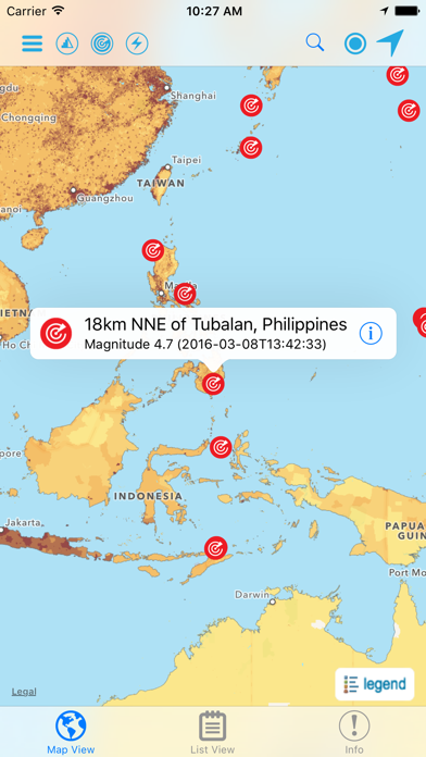
8. Hazards data include the location of active fires over the past 48 hours; earthquake alerts over the past seven days; and yesterday′s air pollution data measured from space.
9. By drawing a circle around a point or area of interest on the map, users can obtain an estimate of the total population and land area enclosed within.
10. The custom population estimates are provided by the SEDAC Population Estimation Service (PES) based on SEDAC′s Gridded Population of the World, version 4 (GPWv4) data for 2015.
11. Journalists or students can explore the location of recent wildfires relative to dense populations, roads, terrain, and water bodies.
或按照以下指南在PC上使用 :
选择你的电脑版本:
软件安装要求:
可直接下载。下载如下:
现在,打开已安装的模拟器应用程序并查找其搜索栏。一旦找到它,请键入 Hazards and Population Mapper 在搜索栏并按搜索。点击 Hazards and Population Mapper应用程序图标。一个 窗口 Hazards and Population Mapper 在Play商店或应用程序商店将打开并且它将在您的模拟器应用程序中显示商店。现在,按下安装按钮并像在iPhone或Android设备上一样,您的应用程序将开始下载。现在我们都完成了。
你会看到一个名为“所有应用程序”的图标。
点击它,它会带你到一个包含所有已安装应用程序的页面。
你应该看到 图标。点击它并开始使用该应用程序。
下载 Hazards and Population Mapper 对于Mac OS (Apple)
| 下载 | 开发人员 | 评论 | 评分 |
|---|---|---|---|
| Free 对于Mac OS | NASA | 6 | 3.33 |

NASA

NASA Lunar Electric Rover Simulator

iMorpheus

NASA Visualization Explorer

NASA Desert RATS Virtual Test Site

韩剧TV-极速版追剧大本营

网易有道词典-高效学习App

百度翻译-英语学习必备

翻译 - 立即翻译

浏览器-360度全新打造的平板浏览器
Google 翻译

追书大师

裁判文书网

一起考教师Pro-教师资格证考试宝典

金山词霸-英语学习高考词典翻译软件

中国法律汇编 - 法律法规文库/司法解释

DeepL翻译

北京e窗通

顶点小说-小说电子书阅读神器

腾讯翻译君-语音翻译和英语词典
 PcMac China