Last Updated by GPS Software Kft. on 2025-04-15
What is Setech? The Setech Térkép mobile application has been updated to make it easier for users to manage their vehicles and achieve savings through the service. The system is regularly maintained and updated to ensure reliable service. The updated mobile application offers real-time tracking of vehicles, comprehensive and detailed analysis of past routes, overview of the entire fleet on the map, checking of current vehicle data, customized data exports, downloadable and printable route logs, and setting of JDB category for toll-paying vehicles.
1. Az alkalmazás megújításával célunk az, hogy megkönnyítsük a jármű kezeléssel kapcsolatos teendőid, és megtakarításokat érj el szolgáltatásunkkal.
2. A technika fejlődése által támasztott követelmények és a felhasználói igények alapján a mobil applikációnkat megújítottuk tartalmilag és megjelenésében is.
3. Rendszerünket folyamatos karbantartjuk és a rendszeresen frissítjük, hogy a legújabb eszközökön is tökéletesen működjön.
4. Ennek eredményeként hosszú évek óta megbízható szolgáltatást nyújtunk.
5. - és végül, de nem utolsó sorban az útdíjköteles járművek JDB kategória állítása.
6. Liked Setech? here are 5 Navigation apps like Google Maps; Waze Navigation & Live Traffic; ParkMobile: Park. Pay. Go.; Transit • Subway & Bus Times; Yahoo!カーナビ;
Or follow the guide below to use on PC:
Select Windows version:
Install Setech app on your Windows in 4 steps below:
Download a Compatible APK for PC
| Download | Developer | Rating | Current version |
|---|---|---|---|
| Get APK for PC → | GPS Software Kft. | 1 | 4.21.261 |
Download on Android: Download Android
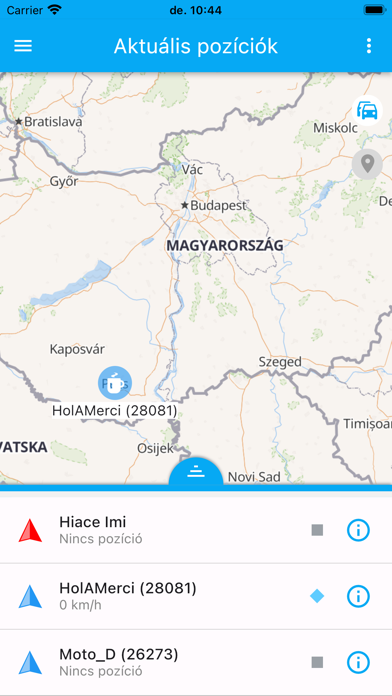
- Real-time tracking of vehicles
- Comprehensive and detailed analysis of past routes
- Overview of the entire fleet on the map
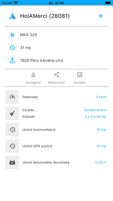
- Checking of current vehicle data
- Customized data exports, downloadable and printable route logs (Excel, PDF)
- Setting of JDB category for toll-paying vehicles
- All vehicles visible on the map in the Current Positions function
- Tracking of selected vehicle's position and movement
- Analysis of selected vehicle's data
- Choice of map display styles
- Analysis of information related to routes taken in the past using the Past Positions function
- Graphical representation of analysis with interactive map and graph
- Evaluation function for analyzing routes based on different criteria
- Sectioning of routes based on ignition or idle time
- Downloadable and printable data exports
- Adjustment of JDB category for toll-paying vehicles on the go and checking of current JDB category.
 PC Apps