US Public Lands for pc and mac

US Public Lands for Pc

Written by Two Steps Beyond


Get a Compatible APK for PC


Download Developer Rating Score Current version Adult Ranking
Check for APK → Two Steps Beyond 632 4.41296 2022.11 4+

★ ★ ★ US Public Lands Overview


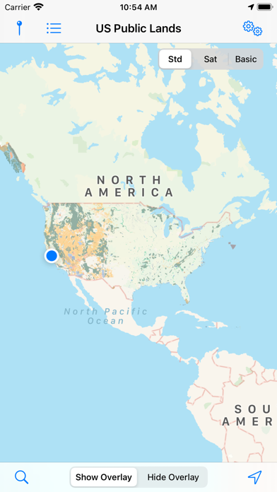
What is US Public Lands? The US Public Lands app allows users to retrieve the boundaries of public lands administered by the federal government without carrying physical maps or digging deep online. The app includes on-device map layers for most of the properties administered by the federal government, and links to each agency's website for further research on land use rules. The app also includes a search tool, GPS access, and the ability to toggle between different map layers.


Software Features and Description

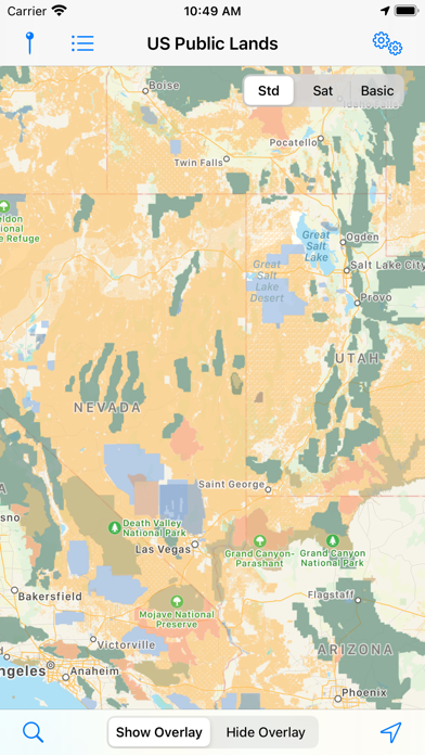
1. - A boondocker's assistant - While US Public Lands is not specifically a camp site locator and does not have a database of specific sites, by turning on the satellite view map, you can better scout out trails, roads and signs of dispersed camping locations within the boundaries of the public land resources.

2. - If you have an internet connection (or have cached them before going out of signal), you can utilize the built in Apple Maps and satellite view maps as the base layer underneath the public land overlays.

3. Thank you to the Protected Area Database (PAD-US) of the U.S. Geological Survey for providing the public domain raw map data that we’ve been able to utilize to create this interactive overlayable mapping & navigation tool.

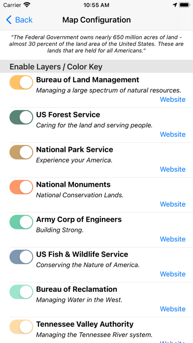
4. - Links are provided to each agency's website within the app, so that you can further your research as to what land use rules apply for each public land type - such as permits, fees, activities allowed, and limits of stay.

5. US Public Lands allows you to quickly retrieve the boundaries of these properties without carrying physical maps, books, or digging deep online.

6. - Built in search tool locates anything on device maps supports (requires internet access) - including cities, states, zip codes, addresses and points of interest.

7. - Be sure to turn on the 'Basic' base map to see the US Public Land labels for each land area.

8. The US Public Lands app should only be used as an overview, and you should always confirm more precise details by consulting local field offices, administration websites, and other resources.

9. Please note, the USGS PAD-US database contains the “most up-to-date aggregation of Federal lands and waters” available, but this database is still evolving and some locations may not be listed and others may not have precisely accurate boundaries.

10. And always remember - there may be private unmapped inholdings within any public lands - so always pay attention to local signage, indications, and information.

11. The US Federal Governments owns nearly 650 million acres of land - almost 30 percent of the land area of the United States.

12. Liked US Public Lands? here are 5 Travel apps like App to Islands of Adventure; TUI Poland - biuro podróży; VR Guide: Cape Cod and Islands; Magic Guide for Disneyland; Traffic Portland;


Download and install US Public Lands on your computer


Hurray! Seems an app like us public lands is available for Windows! Download below:

SN App Download Review Maker
1 Avast Antivirus Download Center Download 4.4/5
1,718 Reviews
4.4
AVAST Software
2 CPlus for Craigslist Download 4.1/5
1,004 Reviews
4.1
YanFlex
3 Journey of Columbus Free Casino Download 4.3/5
535 Reviews
4.3
Casino Labs

Not satisfied? Check for compatible PC Apps or Alternatives


App Download Rating Maker
pc app us public lands Get App or Alternatives 632 Reviews
4.41296
Two Steps Beyond
Or follow the guide below to use on PC:

Select Windows version:

  1. Windows 7-10
  2. Windows 11

Download and install the US Public Lands app on your Windows 10,8,7 or Mac in 4 simple steps below:


  1. Download an Android emulator for PC and Mac:
    Get either Bluestacks or the Nox App >> . We recommend Bluestacks because you can easily find solutions online if you run into problems while using it. Download Bluestacks Pc or Mac software Here >> .

  2. Install the emulator on your PC or Mac:
    On your computer, goto the Downloads folder » click to install Bluestacks.exe or Nox.exe » Accept the License Agreements » Follow the on-screen prompts to complete installation.

  3. Using US Public Lands on PC [Windows 7/ 8/8.1/ 10/ 11]:
    • Open the Emulator app you installed » goto its search bar and search "US Public Lands"
    • The search will reveal the US Public Lands app icon. Open, then click "Install".
    • Once US Public Lands is downloaded inside the emulator, locate/click the "All apps" icon to access a page containing all your installed applications including US Public Lands.
    • Now enjoy US Public Lands on PC.

  4. Using US Public Lands on Mac OS:
    Install US Public Lands on your Mac using the same steps for Windows OS above.


How to download and use US Public Lands App on Windows 11


To get US Public Lands on Windows 11, check if there's a native US Public Lands Windows app here » ». If none, follow the steps below:


  1. Download the Amazon-Appstore » (U.S only)
    • Click on "Get" to begin installation. It also automatically installs Windows Subsystem for Android.
    • After installation, Goto Windows Start Menu or Apps list » Open the Amazon Appstore » Login (with Amazon account)

  2. For non-U.S users, Download the OpenPC software »
    • Upon installation, open OpenPC app » goto Playstore on PC » click Configure_Download. This will auto-download Google Play Store on your Windows 11.

  3. Installing US Public Lands:
    • Login to your computer's PlayStore or Amazon AppStore.
    • Search for "US Public Lands" » Click "Install" to install US Public Lands
    • US Public Lands will now be available on your windows start-menu.

Minimum requirements Recommended
  • 8GB RAM
  • SSD Storage
  • Processor: Intel Core i3, AMD Ryzen 3000
  • Architecture: x64 or ARM64
  • 16GB RAM
  • HDD Storage

US Public Lands On iTunes


Download Developer Rating Score Current version Adult Ranking
$2.99 On iTunes Two Steps Beyond 632 4.41296 2022.11 4+

Download on Android: Download Android


US Public Lands functions

- On-device map layers for most federal government properties, including BLM, FS, NPS, ACOE, US Fish & Wildlife Service, Bureau of Reclamation, Tennessee Valley Authority, Department of Defense, and others

- Links to each agency's website for further research on land use rules

- Map layers stored on device for offline use

- Basic base map layer stored on device for offline use

- Ability to use Apple Maps and satellite view maps as base layer with internet connection

- Boondocker's assistant for scouting out dispersed camping locations within public land boundaries

- GPS access to show present location and type of land

- Built-in search tool for locating cities, states, zip codes, addresses, and points of interest

- Utilizes raw map data from the USGS PAD-US database

- App should only be used as an overview and users should confirm more precise details with local field offices and administration websites.


Pros:

- Allows you to search for BLM land by name, making it easier to locate than the government website

- Maps are overlaid on actual maps, making it easier to navigate and get directions

- Covers other government land for camping

- Shows GPS location on the map in conjunction with colored map overlays

- Low cost for keeping you legal while camping off the beaten track


Cons:

- Uses Apple maps which may be inferior to Google maps in showing all the tiny roads

- Need to download Google offline maps and toggle between apps to navigate off roads when off-grid

- Still misses large areas that are accessible to the public

- Satellite view is critical when in the boonies, but the app does not offer the ability to download satellite and terrain views from Google ahead of time.


Top Pcmac Reviews

  • A tad more useful

    By klein78 (Pcmac user)

    I am upping my review to 2 stars mainly due to fact that if you are in the boonies, at least you would click the 'basic' map and 'locate' and you may know if you are trespassing or not. The good: - it keeps you 'legal' as much as possible; if in doubt, better backtrack thou - low cost for doing above Still bad: - I think it uses Apple maps which is inferior to Google in showing all the tiny roads (off roads - even though I found many Google tiny roads that were gone when checking them on location but still showing on maps - not this app problem to fix). - you need to download google offline maps, then toggle between this app and google maps to navigate the maze of off roads when off grid - still misses large areas that are accessible to public but again, not big deal since there are so many public lands in western states Ideally when in the boonies and no coverage, satellite view is critical if you want to change locations if one proves inaccessible. Being able to download ahead of time the sat view and terrain view from google then lay over the ownership map, would make this app worth a lot. I would pay easily 50$ for one stop shop. Other apps that do that are pricey and require subscription etc. Again, great idea, I hope the developers improve it.
  • Brilliant app!

    By BaadB (Pcmac user)

    The info you get from the government sites on where exactly blm starts or even where blm land is located is very hard to pinpoint. This app allows you to search by name and while not accurate to exact boundaries is more accurate than the blm website. The maps there are very hard to read while this one is overlaid on actual maps so you can figure out directions and get where you want to go. I like that it also covers other government land for you to stay on. This app is a must have if you love camping off the beaten track.
  • It does what it says it does

    By pgib9981 (Pcmac user)

    My husband and I love 4-wheeling out to the middle of nowhere and staying a few days. Many times we’ve wondered if we were on BLM land or not. Now we know. I love that it shows your gps location on the map in conjunction with the colored map overlays. (Although I don’t believe it shows the coordinates.) If you’re looking for a basic app that shows if you’re on public land or not, then this is the app for you. If you need something that shows campgrounds and has all the frills, then look elsewhere.
  • Love the New Update

    By Slimbeaux (Pcmac user)

    With this new update any review more then 6 months old may not tell the whole story. With the new update to fully use the features you need cell service. But being able to have three different view. With satellite view you can see if there are other campers there. Then turn on the overlay to see who is the land manager. Great tool.

Similar Travel apps


More apps from the Developer