Published by Gauld Developments on 2024-04-18
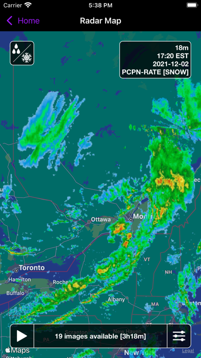
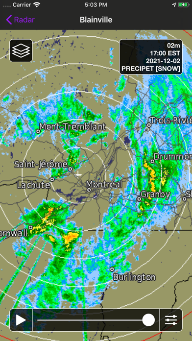
What is Canada Weather? The Canadian Weather app provides users with access to various weather-related information such as radar images, satellite imagery, GFA, and surface analysis charts. The app is location-aware and can automatically find the closest radar station. Users can select from a list of 31 stations nationwide, including five regional views: Pacific, Prairies, Ontario, Quebec, and Atlantic. The app also allows users to view up to 3 hours of radar animations for all of North America and choose between Reflectivity or Precipitation Rate (rain/snow). Users can customize animation speed, delay, radar opacity, and map type. The app also provides satellite imagery from the GOES-16 weather satellite in visible light, infrared, and combined. Users can choose between the Meteorological Society of Canada (MSC) or the US National Oceanic and Atmospheric Administration (NOAA) and animate up to 6 hours of imagery. The app also allows users to view Surface Analysis and Graphical Area Forecast (GFA) charts for all of Canada.
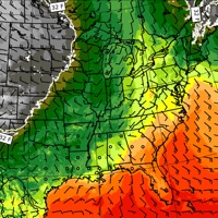
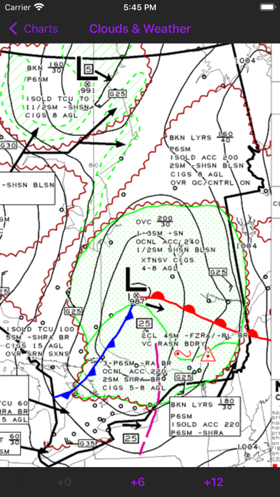
1. GFAs give you a 12-hour forecast of the expected pressure and frontal systems at a regional level, along with information such as expected precipitation, cloud height & coverage, turbulence, icing, and freezing level.
2. View Canadian weather radar, satellite imagery, GFA, and surface analysis charts.
3. View Surface Analysis and Graphical Area Forecast (GFA) charts for all of Canada.
4. Choose between the Meteorological Society of Canada (MSC) or the US National Oceanic and Atmospheric Administration (NOAA) and animate up to 6 hours of imagery.
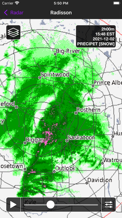
5. View up to 3 hours of radar animations for all of North America and choose between Reflectivity or Precipitation Rate (rain/snow).
6. The Surface Analysis is a snapshot of the current pressure and frontal systems across Canada.
7. View satellite imagery from the GOES-16 weather satellite in visible light, infrared, and combined.
8. Quickly switch between 0/+6/+12 GFA images and between "Clouds & Weather" and "Icing, Turbulence, & Freezing Level" images.
9. Canada Weather is location-aware and can automatically find the closest radar station.
10. Visit the Environment Canada website for a detailed map of radar coverage in your area.
11. While these charts are typically used by pilots, they offer an excellent look at the current weather systems in a given region.
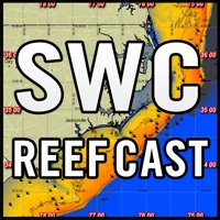
12. Liked Canada Weather? here are 5 Weather apps like Weather Models; NOAA Buoys Marine Weather PRO; Weather Lab - 3D; WHIO Weather; ReefCast Marine Weather;
Or follow the guide below to use on PC:
Select Windows version:
Install Canada Weather app on your Windows in 4 steps below:
Download a Compatible APK for PC
| Download | Developer | Rating | Current version |
|---|---|---|---|
| Get APK for PC → | Gauld Developments | 4.50 | 3.7 |
Get Canada Weather on Apple macOS
| Download | Developer | Reviews | Rating |
|---|---|---|---|
| Get $0.99 on Mac | Gauld Developments | 22 | 4.50 |
Download on Android: Download Android
- Location-aware and can automatically find the closest radar station
- Select from a list of 31 stations nationwide, including five regional views: Pacific, Prairies, Ontario, Quebec, and Atlantic
- Animate up to 100 images calibrated for either rain or snow and displayed in one of two preset formats
- View up to 3 hours of radar animations for all of North America and choose between Reflectivity or Precipitation Rate (rain/snow)
- Customize animation speed, delay, radar opacity, and map type
- View satellite imagery from the GOES-16 weather satellite in visible light, infrared, and combined
- Choose between the Meteorological Society of Canada (MSC) or the US National Oceanic and Atmospheric Administration (NOAA) and animate up to 6 hours of imagery
- View Surface Analysis and Graphical Area Forecast (GFA) charts for all of Canada
- Quickly switch between 0/+6/+12 GFA images and between "Clouds & Weather" and "Icing, Turbulence, & Freezing Level" images
- View GFA pairs side-by-side instead of having to switch between them
- Data Providers: Radar: Environment Canada, Satellite: Meteorological Service of Canada (MSC), National Oceanic and Atmospheric Administration (NOAA), Cooperative Institute for Research in the Atmosphere (CIRA), Charts: NAV CANADA.
App Freezes
 PC Apps