Written by Flytomap
Get a Compatible APK for PC
| Download | Developer | Rating | Score | Current version | Adult Ranking |
|---|---|---|---|---|---|
| Check for APK → | Flytomap | 0 | 5.7 | 4+ |
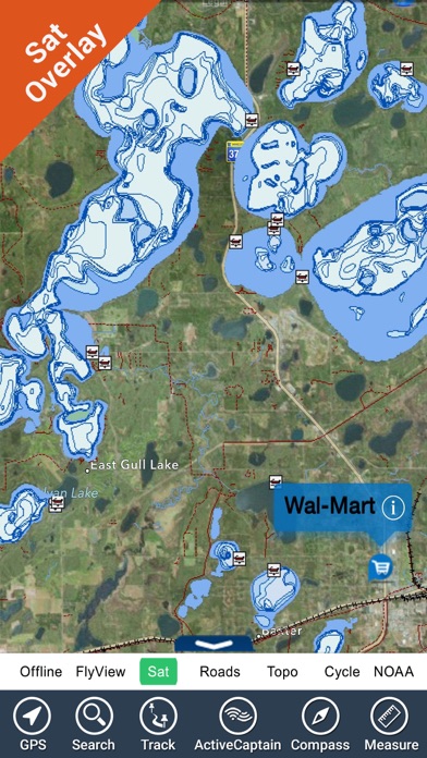

What is Lake Lanier GA HD Fishing Maps? Flytomap is a navigation app that provides worldwide marine, lakes, and outdoor maps. It offers satellite images overlay on charts, terrain features overlay on charts, local weather forecast, and NOAA, USGS, DRG, Topo raster charts seamless with continuous updates from the official Government server. The app also features ActiveCaptain, a worldwide boaters and fishermen community, with 200,000+ captains. It allows users to explore latitudes and longitudes, search favorite points directly, zoom, rotate and pan fast just by a finger touch, and get quick object information just tapping, thanks to vector technology. The app also offers GPS heading vector towards the direction movement, distance measurement tool, route planning, waypoints, magnified lens for all info, unlimited tracks, markers, fishing spots, geo-tagged photos, records, and share via email, visible on Google, Flytomap Viewer, KMZ format. It also features select depth contours, a la carte menu, MOB - Man Over Board, Quick WP, iOS background mode, and optimized battery usage.
1. Flytomap is committed to constant improvement, this App is developed with the help of professional boaters to get the best experience on the sea, we listen to our users and systematically add the most requested features.
2. √ iOS background mode - Flytomap works in background as well, you can swap with another app and receive/make calls send sms while track recording.
3. Lake Lanier Georgia - The whole coverage resident in the app.
4. Liked Lake Lanier GA HD Fishing Maps? here are 5 Navigation apps like Lake Lanier GA Fishing Charts; Lake Sidney Lanier gps offline chart for boaters; Lake Sidney Lanier GPS Charts; Powell - Glen Canyon N offline lake & park trails; Lakes Texas GPS fishing charts;
| SN | App | Download | Review | Maker |
|---|---|---|---|---|
| 1 |  i-Boating: GPS Nautical / Marine Charts - offline sea, lake river navigation maps for fishing, sailing, boating, yachting, diving & cruising
|
Download | 4/5 200 Reviews 4
|
Bist LLC |
| 2 |  i-Boating : Marine Navigation Charts & Lake Maps GPS
|
Download | 5/5 14 Reviews 5
|
Bist LLC |
| 3 |  Marine Navigation HD - USA - Lake Depth Maps - Offline Gps Nautical Charts for Fishing, Sailing, Boating, Yachting, Diving & Cruising
|
Download | 2.6/5 13 Reviews 2.6
|
Bist LLC |
Not satisfied? Check for compatible PC Apps or Alternatives
| App | Download | Rating | Maker |
|---|---|---|---|
 lake lanier ga hd fishing maps lake lanier ga hd fishing maps |
Get App or Alternatives | 0 Reviews |
Flytomap |
Select Windows version:
Download and install the Lake Lanier GA HD Fishing Maps app on your Windows 10,8,7 or Mac in 4 simple steps below:
To get Lake Lanier GA HD Fishing Maps on Windows 11, check if there's a native Lake Lanier GA HD Fishing Maps Windows app here » ». If none, follow the steps below:
| Minimum requirements | Recommended |
|---|---|
|
|
Lake Lanier GA HD Fishing Maps On iTunes
| Download | Developer | Rating | Score | Current version | Adult Ranking |
|---|---|---|---|---|---|
| $14.99 On iTunes | Flytomap | 0 | 5.7 | 4+ |
Download on Android: Download Android
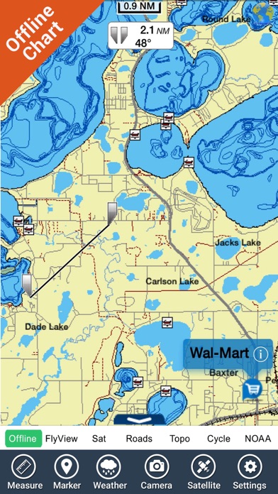
- Worldwide marine, lakes, and outdoor maps
- Satellite images overlay on charts
- Terrain features overlay on charts
- Local weather forecast
- NOAA, USGS, DRG, Topo raster charts seamless with continuous updates from the official Government server
- ActiveCaptain, a worldwide boaters and fishermen community, with 200,000+ captains
- Explore latitudes and longitudes
- Search favorite points directly
- Zoom, rotate and pan fast just by a finger touch
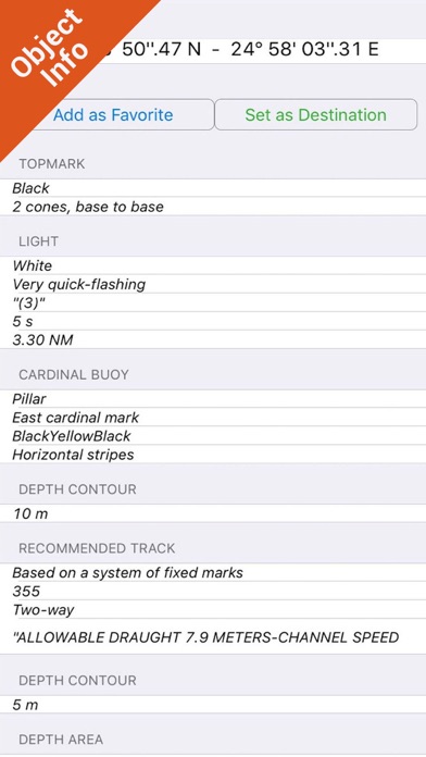
- Quick object information just tapping, thanks to vector technology
- GPS heading vector towards the direction movement
- Distance measurement tool
- Route planning
- Waypoints
- Magnified lens for all info
- Unlimited tracks, markers, fishing spots, geo-tagged photos, records, and share via email, visible on Google, Flytomap Viewer, KMZ format
- Select depth contours
- A la carte menu
- MOB - Man Over Board
- Quick WP
- iOS background mode
- Optimized battery usage
- Local marine weather forecast at a quick tap provide you:
- Day max and min temperature - Current temperature
- Significant wave height, Swell height, Swell period, Swell direction
- Tide data
- Sea temperature
- Wind Speed and direction
- Weather description
- Precipitation & Humidity
- Visibility
- Pressure
- Cloud cover in percentage
- Wind chill/Feels like Temperature
- Water Temperature
- Dew Point Temperature
- Heat Index Temperature
 PC Apps