Last Updated by seawellsoft on 2025-03-01


What is Charleston to Key West Charts?
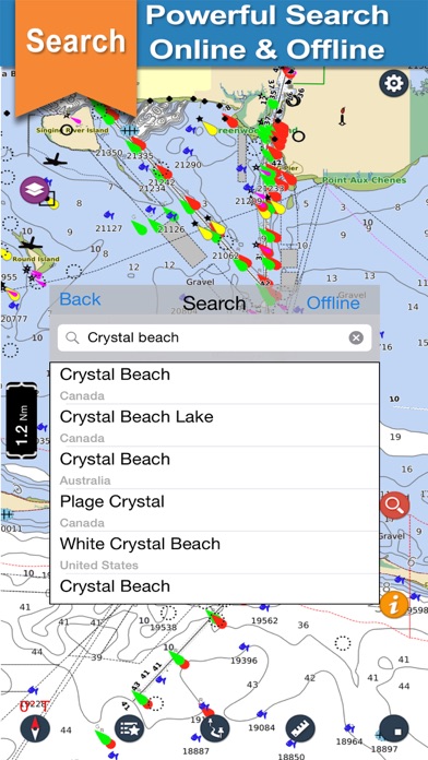
Seawell marine navigation app is designed for sailors, fishermen, divers, boaters, and cruisers. It offers comprehensive coverage of the chart from Charleston to Key West, including Fernandina beach, Daytona beach, Palm beach, Little Bahama Bank, Lake Okeechobee, Port Royal, Indian River, and more. The app provides seamless scrolling, comprehensive coverage, track recording, safety features, and distance measurement. It also has an intuitive interface, favorites list, and multiple overlays.
1. *** For people who are looking for appealing charts, features like seamless scrolling, comprehensive coverage with good chart view management, track recording and safety feature (MOB), Seawell marine navigation applications are the best choice.
2. Coverage of the chart is extensive and detailed: ***Charleston to Key West - Our Chart covers Fernandina beach, Daytona beach, Palm beach, Little Bahama Bank, Lake Okeechobee, Port Royal, Indian River, and so on.
3. Lots of care has been taken to avoid clutter of icons, to utilize the full view of the chart to display only the map.
4. √ Intuitive track detail view helps you to start / stop / pause / continue your track recording.
5. Three modes of GPS tracking, Red denotes user location centered and north up, yellow denotes user location is tracked but not centered with north up and blue denotes user location centered and map is rotated in course UP direction.
6. With Seawell chart application you can zoom in and out without having to look for and load different charts.
7. With a single ON/OFF button, you can have full chart clear view.
8. You can still scroll/zoom even when the favorites list or track list view is open.
9. You can also mark or add favorite spots, dynamically without going back and forth to the chart.
10. √ You can simply use your finger to tap positions on the chart where you want favorites.
11. √ Intuitive interface to turn a track ON/ OFF, edit details & delete.
12. Liked Charleston to Key West Charts? here are 5 Navigation apps like Charleston Travel Guide; Lake Winnipesaukee offline chart for boaters; Boating Florida Nautical Chart; Lake Norman GPS Nautical Chart; Japan Chart Navi;
GET Compatible PC App
| App | Download | Rating | Maker |
|---|---|---|---|
 Charleston to Key West Charts Charleston to Key West Charts |
Get App ↲ | 0 1 |
seawellsoft |
Or follow the guide below to use on PC:
Select Windows version:
Install Charleston to Key West Charts app on your Windows in 4 steps below:
Download a Compatible APK for PC
| Download | Developer | Rating | Current version |
|---|---|---|---|
| Get APK for PC → | seawellsoft | 1 | 3.1 |
Get Charleston to Key West Charts on Apple macOS
| Download | Developer | Reviews | Rating |
|---|---|---|---|
| Get $6.99 on Mac | seawellsoft | 0 | 1 |
Download on Android: Download Android
- Comprehensive coverage of the chart
- Seamless scrolling
- Chart view management
- Track recording
- Favorites list
- Distance measure
- MOB function (Man Overboard)
- Online and offline search
- Speed of boat
- Add images in favorites
- Multiple overlays: Offline, Hybrid, Topo, and Street mode.
 PC Apps