Last Updated by Flytomap on 2025-04-22
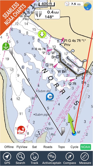
What is Boating Miami to Key West GPS? Flytomap is a navigation app that provides worldwide marine and outdoor maps, satellite images overlay on charts, terrain features overlay on charts, local marine weather forecast, NOAA raster charts with continuous updates, and ActiveCaptain - a worldwide boaters community. The app allows users to explore their favorite places, search for points of interest, zoom, rotate and pan fast, get quick object information, use GPS heading vector towards the direction of movement, measure distance, plan routes, insert waypoints, select depth contours, and use MOB and Quick WP features. The app also works in the background, has optimized battery usage, and provides local marine weather forecast.
1. Flytomap is committed to constant improvement, this App is developed with the help of professional boaters to get the best experience on the sea, we listen to our users and systematically add the most requested features.
2. √ iOS background mode - Flytomap works in background as well, you can swap with another app and receive/make calls send sms while track recording.
3. Miami to Key West - The whole coverage resident in the app.
4. Liked Boating Miami to Key West GPS? here are 5 Navigation apps like Miami Trolleys; ParkMe - Miami Beach; Transit Tracker - Miami Dade; Miami City Maps - Discover MIA with MRT & Guides; Smart Park Miami;
GET Compatible PC App
| App | Download | Rating | Maker |
|---|---|---|---|
 Boating Miami to Key West GPS Boating Miami to Key West GPS |
Get App ↲ | 2 2.00 |
Flytomap |
Or follow the guide below to use on PC:
Select Windows version:
Install Boating Miami to Key West GPS app on your Windows in 4 steps below:
Download a Compatible APK for PC
| Download | Developer | Rating | Current version |
|---|---|---|---|
| Get APK for PC → | Flytomap | 2.00 | 5.7 |
Get Boating Miami to Key West GPS on Apple macOS
| Download | Developer | Reviews | Rating |
|---|---|---|---|
| Get $9.99 on Mac | Flytomap | 2 | 2.00 |
Download on Android: Download Android
- Worldwide marine and outdoor maps
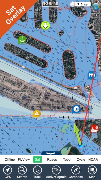
- Satellite images overlay on charts
- Terrain features overlay on charts
- Local marine weather forecast
- NOAA raster charts with continuous updates
- ActiveCaptain - a worldwide boaters community
- Explore favorite places
- Search for points of interest
- Zoom, rotate and pan fast
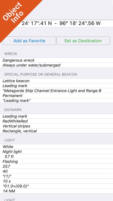
- Quick object information
- GPS heading vector towards the direction of movement
- Distance measurement tool
- Route planning
- Waypoints insertion
- Magnified lens for all info
- Unlimited tracks, markers, geo-tagged photos, records, and share via email
- Select depth contours
- A la carte menu
- MOB - Man Over Board
- Quick WP - instantly record position and show distance and bearing
- iOS background mode
- Optimized battery usage
- Local marine weather forecast
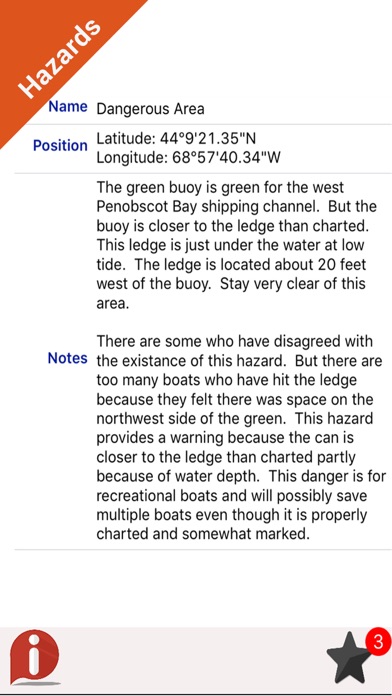
- Continuous update of all info about marinas, anchorages, hazards, and local knowledge
- Tide data
- Sea temperature
- Wind speed and direction
- Weather description
- Precipitation and humidity
- Visibility
- Pressure
- Cloud cover in percentage
- Wind chill/Feels like Temperature
- Water Temperature
- Dew Point Temperature
- Heat Index Temperature
- Compatible with GARMIN, NAVICO, LOWRANCE, B&G, NORTHSTAR, EAGLE, and SIMRAD
- Social media presence on Twitter, Facebook, and Web Site
- Constant improvement based on user feedback.
- GPS tracking accurately records distance, speed, and time
- Offers offline and satellite features
- Navigation compass is available
- Interface is outstanding with various options
- Free updates keep things interesting and exciting
- Shows exact GPS location during drives
- None mentioned in the review
Does what it says
Suberb!
Good for tracking
AmaZing!
 PC Apps