
Được viết bởi Jeff Maynard
1. JOURNEY PLANNER: select a starting point and destination from the supplied list of 102 landmarks (including locks, marinas, moorings, bridges and places of interest (from Lechlade to the Thames Barrier) and immediately see the sailing distance, direction (up or downstream), sailing time (at 5 mph, 3 mph and 1 mph) and the number of locks to transit to complete your journey; Wey navigation planner features 45 locations.
2. CURRENT RIVER CONDITIONS*: for safer river use always verify the current official conditions before setting off; non-tidal conditions are provided by the Environment Agency (the River Thames authority) and categorised as Red, Yellow or Green – tap to view an explanation of the colours.
3. IN CASE OF EMERGENCY: River Thames Guide includes an SOS section with information, endorsed by the RNLI, on how to deal with various problems including: Man Overboard; Boat Sinking; Boat on Fire; Boat Drifting.
4. Add any combination of locks, moorings, boatyards, fuel, marinas, pubs, restaurants, lodgings, sanitation, fishing, emergency RVP and/or bridges; tapping any icon pops up further details including phone number, post code, maximum stay etc (where available).
5. HELP: every page contains tips on using River Thames Guide to help plan your journey, find somewhere to eat or stay, using the map, and more.
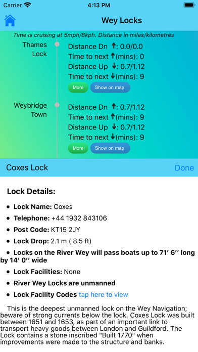
6. Touch any lock to see much more information including: telephone number; post code; lock type; width, drop and length; lock keeper’s hours; facilities available (such as WC, water, pump out etc).
7. LOCK FEATURES: every Thames lock is listed in order from Cricklade Bridge to Teddington with distance to next lock both up and downstream.
8. WEATHER*: select one of 20 location on the river for an up-to-date weather forecast for today and tomorrow (includes temperature, winds, humidity, visibility, sunrise and sunset).
9. BRIDGE HEADWAY: every bridge listed in order with headway in feet and metres; bridge headways are colour coded for ease of use and instant check to see if you need to lower any masts.
10. Includes current and planned river closures and river restrictions.
11. INTERACTIVE RIVER MAP*: pinch or squeeze to zoom to the required level of detail.


Kiểm tra Ứng dụng / Ứng dụng thay thế PC tương thích
| Ứng dụng | Tải về | Xếp hạng | Nhà phát triển |
|---|---|---|---|
|
River Thames Guide Lite
|
Tải ứng dụng ↲ | 0 1
|
Jeff Maynard |
Hoặc làm theo hướng dẫn dưới đây để sử dụng trên PC :
messages.choose_pc:
Yêu cầu Cài đặt Phần mềm:
Có sẵn để tải xuống trực tiếp. Tải xuống bên dưới:
Bây giờ, mở ứng dụng Trình giả lập bạn đã cài đặt và tìm kiếm thanh tìm kiếm của nó. Một khi bạn tìm thấy nó, gõ River Thames Guide Lite trong thanh tìm kiếm và nhấn Tìm kiếm. Bấm vào River Thames Guide Litebiểu tượng ứng dụng. Một cửa sổ River Thames Guide Lite trên Cửa hàng Play hoặc cửa hàng ứng dụng sẽ mở và nó sẽ hiển thị Cửa hàng trong ứng dụng trình giả lập của bạn. Bây giờ nhấn nút Tải xuống và, như trên thiết bị iPhone hoặc Android của bạn, ứng dụng của bạn sẽ bắt đầu tải xuống. Bây giờ chúng ta đã xong.
Bạn sẽ thấy một biểu tượng có tên "Tất cả ứng dụng".
Click vào nó và nó sẽ đưa bạn đến một trang chứa tất cả các ứng dụng đã cài đặt của bạn.
Bạn sẽ thấy biểu tượng. Click vào nó và bắt đầu sử dụng ứng dụng.
Nhận APK tương thích cho PC
| Tải về | Nhà phát triển | Xếp hạng | Phiên bản hiện tại |
|---|---|---|---|
| Tải về APK dành cho PC » | Jeff Maynard | 1 | 25.04 |
Tải về River Thames Guide Lite cho Mac OS (Apple)
| Tải về | Nhà phát triển | Bài đánh giá | Xếp hạng |
|---|---|---|---|
| Free cho Mac OS | Jeff Maynard | 0 | 1 |

Airport Codes Database

River Thames Guide
River Thames Guide Lite

Eurosceptic

Airport Airline Codes Database
Google Maps - Transit & Food

be - Vietnamese ride-hailing

Geocaching®

QH Đồng Nai

QH Bà Rịa - Vũng Tàu

Thongtin.land -

QH Bình Dương

GV-SHIP - Giao hàng nhanh

Tìm Buýt

Moovit: Public Transport Live

Japan Transit Planner

BusMap - Navigation & Timing

ShipVN - Tìm shipper, săn ship

Find my Phone, Friends - iMapp

Quy hoạch Bà Rịa - Vũng Tàu
 PcMac Việt