Escrito por Jeff Maynard
1. JOURNEY PLANNER: select a starting point and destination from the supplied list of 102 landmarks (including locks, marinas, moorings, bridges and places of interest (from Lechlade to the Thames Barrier) and immediately see the sailing distance, direction (up or downstream), sailing time (at 5 mph, 3 mph and 1 mph) and the number of locks to transit to complete your journey; Wey navigation planner features 45 locations.
2. CURRENT RIVER CONDITIONS*: for safer river use always verify the current official conditions before setting off; non-tidal conditions are provided by the Environment Agency (the River Thames authority) and categorised as Red, Yellow or Green – tap to view an explanation of the colours.
3. IN CASE OF EMERGENCY: River Thames Guide includes an SOS section with information, endorsed by the RNLI, on how to deal with various problems including: Man Overboard; Boat Sinking; Boat on Fire; Boat Drifting.
4. Add any combination of locks, moorings, boatyards, fuel, marinas, pubs, restaurants, lodgings, sanitation, fishing, emergency RVP and/or bridges; tapping any icon pops up further details including phone number, post code, maximum stay etc (where available).
5. HELP: every page contains tips on using River Thames Guide to help plan your journey, find somewhere to eat or stay, using the map, and more.
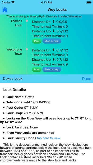
6. Touch any lock to see much more information including: telephone number; post code; lock type; width, drop and length; lock keeper’s hours; facilities available (such as WC, water, pump out etc).
7. LOCK FEATURES: every Thames lock is listed in order from Cricklade Bridge to Teddington with distance to next lock both up and downstream.
8. WEATHER*: select one of 20 location on the river for an up-to-date weather forecast for today and tomorrow (includes temperature, winds, humidity, visibility, sunrise and sunset).
9. BRIDGE HEADWAY: every bridge listed in order with headway in feet and metres; bridge headways are colour coded for ease of use and instant check to see if you need to lower any masts.
10. Includes current and planned river closures and river restrictions.
11. INTERACTIVE RIVER MAP*: pinch or squeeze to zoom to the required level of detail.


Verificar aplicaciones o alternativas de PC compatibles
| Aplicación | Descargar | Calificación | Desarrollador |
|---|---|---|---|
|
River Thames Guide Lite
|
Obtener aplicación o alternativas ↲ | 0 1
|
Jeff Maynard |
O siga la guía a continuación para usar en PC :
Elija la versión de su PC:
Requisitos de instalación del software:
Disponible para descarga directa. Descargar a continuación:
Ahora, abra la aplicación Emulator que ha instalado y busque su barra de búsqueda. Una vez que lo encontraste, escribe River Thames Guide Lite en la barra de búsqueda y presione Buscar. Haga clic en River Thames Guide Liteicono de la aplicación. Una ventana de River Thames Guide Lite en Play Store o la tienda de aplicaciones se abrirá y mostrará Store en su aplicación de emulador. Ahora, presione el botón Instalar y, como en un iPhone o dispositivo Android, su aplicación comenzará a descargarse. Ahora hemos terminado.
Verá un ícono llamado "Todas las aplicaciones".
Haga clic en él y lo llevará a una página que contiene todas sus aplicaciones instaladas.
Deberías ver el icono. Haga clic en él y comience a usar la aplicación.
Obtén un APK compatible para PC
| Descargar | Desarrollador | Calificación | Versión actual |
|---|---|---|---|
| Descargar APK para PC » | Jeff Maynard | 1 | 25.04 |
Descargar River Thames Guide Lite para Mac OS (Apple)
| Descargar | Desarrollador | Reseñas | Calificación |
|---|---|---|---|
| Free para Mac OS | Jeff Maynard | 0 | 1 |

Airport Codes Database

River Thames Guide
River Thames Guide Lite

Eurosceptic

Airport Airline Codes Database
Google Maps - trafico y comida

Waze Navegación y Tráfico

Moovit: Transporte público

Family Locator - GPS Tracker

Street View Map 360 - Travel

UNE Transporte Sonora

RealLoc localizador de celular

SpTH

Waze Carpool

Rastreo de Ubicación - buscar

Rastreador GPS de Celulares

GPS tracker. Buscar Amigos

Yo! Estacionandome

Zeek Mi Auto

maps + more
 PcMac Español