
ลงรายการบัญชีโดย ลงรายการบัญชีโดย Jeff Maynard
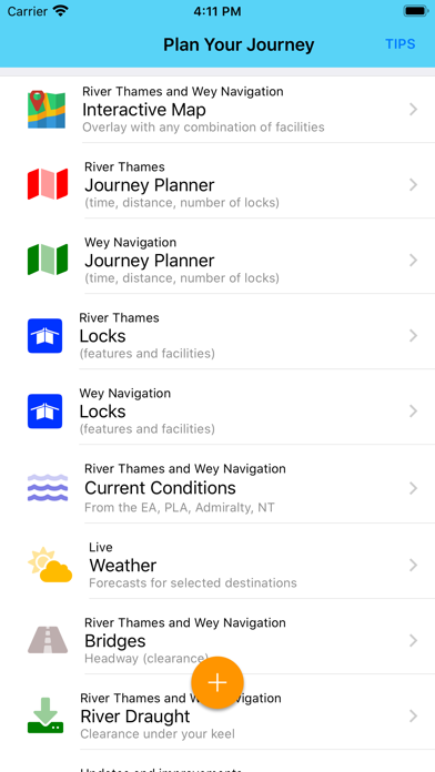
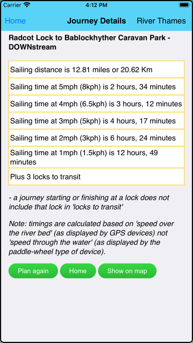
1. JOURNEY PLANNER: select a starting point and destination from the supplied list of 102 landmarks (including locks, marinas, moorings, bridges and places of interest (from Lechlade to the Thames Barrier) and immediately see the sailing distance, direction (up or downstream), sailing time (at 5 mph, 3 mph and 1 mph) and the number of locks to transit to complete your journey; Wey navigation planner features 45 locations.
2. Add any combination of locks, moorings, boatyards, fuel, marinas, pubs, restaurants, lodgings, sanitation, fishing, emergency RVP and/or bridges; tapping any icon pops up further details including phone number, post code, maximum stay etc (where available).
3. IN CASE OF EMERGENCY: River Thames Guide includes an SOS section with information, endorsed by the RNLI, on how to deal with various problems including: Man Overboard; Boat Sinking; Boat on Fire; Boat Drifting.
4. CURRENT RIVER CONDITIONS: for safer river use always verify the current official conditions before setting off; non-tidal conditions are provided by the Environment Agency (the River Thames authority) and categorised as Red, Yellow or Green – tap to view an explanation of the colours.
5. Touch any lock to see much more information including: telephone number; post code; lock type; width, drop and length; lock keeper’s hours; facilities available (such as WC, water, pump out etc).
6. HELP: every page contains tips on using River Thames Guide to help plan your journey, find somewhere to eat or stay, using the map, and more.
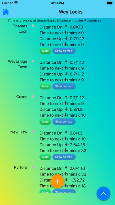
7. LOCK FEATURES: every Thames lock is listed in order from Cricklade Bridge to Teddington with distance to next lock both up and downstream.
8. The interactive map is built-in to the App so you do not need an Internet connection to see where you are and facilities near you (PLEASE NOTE: this means a large download - please be patient, it’s worth it!).
9. WEATHER: select one of 20 location on the river for an up-to-date weather forecast for today and tomorrow (includes temperature, winds, humidity, visibility, sunrise and sunset).
10. BRIDGE HEADWAY: every bridge listed in order with headway in feet and metres; bridge headways are colour coded for ease of use and instant check to see if you need to lower any masts.
11. INTERACTIVE RIVER MAP: pinch or squeeze to zoom to the required level of detail.

ตรวจสอบแอปพีซีหรือทางเลือกอื่นที่เข้ากันได้
| โปรแกรม ประยุกต์ | ดาวน์โหลด | การจัดอันดับ | เผยแพร่โดย |
|---|---|---|---|
|
River Thames Guide
|
รับแอปหรือทางเลือกอื่น ↲ | 1 5.00
|
Jeff Maynard |
หรือทำตามคำแนะนำด้านล่างเพื่อใช้บนพีซี :
เลือกเวอร์ชันพีซีของคุณ:
ข้อกำหนดในการติดตั้งซอฟต์แวร์:
พร้อมให้ดาวน์โหลดโดยตรง ดาวน์โหลดด้านล่าง:
ตอนนี้เปิดแอพลิเคชัน Emulator ที่คุณได้ติดตั้งและมองหาแถบการค้นหาของ เมื่อคุณพบว่า, ชนิด River Thames Guide ในแถบค้นหาและกดค้นหา. คลิก River Thames Guideไอคอนโปรแกรมประยุกต์. River Thames Guide ในร้านค้า Google Play จะเปิดขึ้นและจะแสดงร้านค้าในซอฟต์แวร์ emulator ของคุณ. ตอนนี้, กดปุ่มติดตั้งและชอบบนอุปกรณ์ iPhone หรือ Android, โปรแกรมของคุณจะเริ่มต้นการดาวน์โหลด. ตอนนี้เราทุกคนทำ
คุณจะเห็นไอคอนที่เรียกว่า "แอปทั้งหมด "
คลิกที่มันและมันจะนำคุณไปยังหน้าที่มีโปรแกรมที่ติดตั้งทั้งหมดของคุณ
คุณควรเห็นการร
คุณควรเห็นการ ไอ คอน คลิกที่มันและเริ่มต้นการใช้แอพลิเคชัน.
รับ APK ที่เข้ากันได้สำหรับพีซี
| ดาวน์โหลด | เผยแพร่โดย | การจัดอันดับ | รุ่นปัจจุบัน |
|---|---|---|---|
| ดาวน์โหลด APK สำหรับพีซี » | Jeff Maynard | 5.00 | 24.11 |
ดาวน์โหลด River Thames Guide สำหรับ Mac OS (Apple)
| ดาวน์โหลด | เผยแพร่โดย | ความคิดเห็น | การจัดอันดับ |
|---|---|---|---|
| Free สำหรับ Mac OS | Jeff Maynard | 1 | 5.00 |

Airport Codes Database
River Thames Guide
River Thames Guide Lite

Eurosceptic

Airport Airline Codes Database

7-Eleven TH

LINE MAN: Food Delivery & more

myAIS

กองสลากพลัส

Pinterest: Lifestyle Ideas

QueQ - No more Queue line

dtac

Tinder - Dating & Meet People

SSO Connect

The 1: Rewards, Points, Deals

มังกรฟ้า

Blue Card

CASETiFY Colab

Lemon8

GO by Krungsri Auto
 PcMac ไทย