
写的 - 写的 - Jeff Maynard
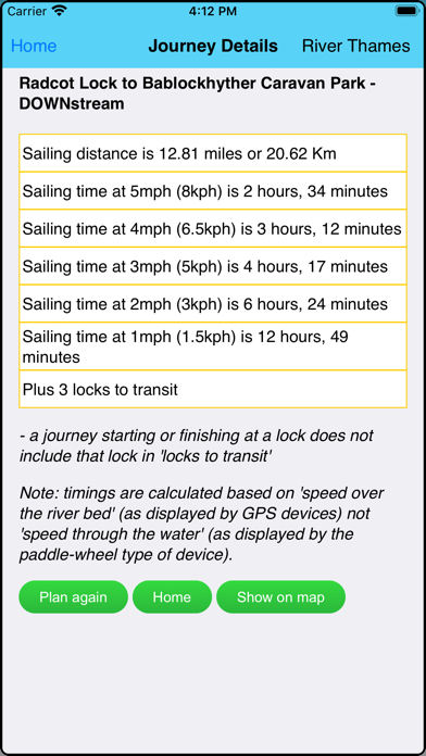
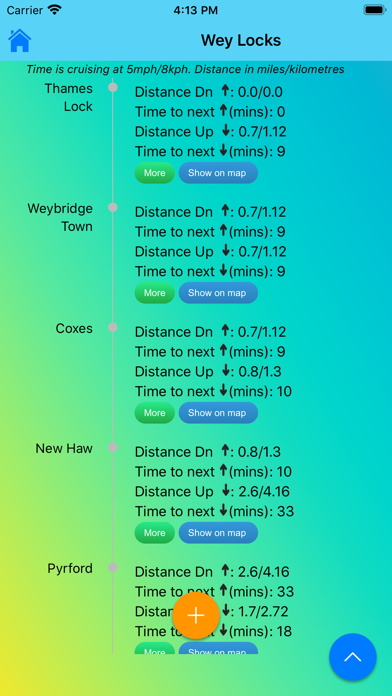
1. JOURNEY PLANNER: select a starting point and destination from the supplied list of 102 landmarks (including locks, marinas, moorings, bridges and places of interest (from Lechlade to the Thames Barrier) and immediately see the sailing distance, direction (up or downstream), sailing time (at 5 mph, 3 mph and 1 mph) and the number of locks to transit to complete your journey; Wey navigation planner features 45 locations.
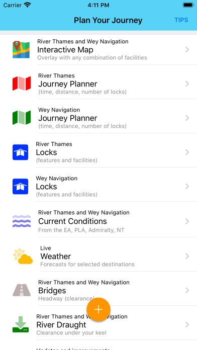
2. Add any combination of locks, moorings, boatyards, fuel, marinas, pubs, restaurants, lodgings, sanitation, fishing, emergency RVP and/or bridges; tapping any icon pops up further details including phone number, post code, maximum stay etc (where available).
3. IN CASE OF EMERGENCY: River Thames Guide includes an SOS section with information, endorsed by the RNLI, on how to deal with various problems including: Man Overboard; Boat Sinking; Boat on Fire; Boat Drifting.
4. CURRENT RIVER CONDITIONS: for safer river use always verify the current official conditions before setting off; non-tidal conditions are provided by the Environment Agency (the River Thames authority) and categorised as Red, Yellow or Green – tap to view an explanation of the colours.
5. Touch any lock to see much more information including: telephone number; post code; lock type; width, drop and length; lock keeper’s hours; facilities available (such as WC, water, pump out etc).
6. HELP: every page contains tips on using River Thames Guide to help plan your journey, find somewhere to eat or stay, using the map, and more.
7. LOCK FEATURES: every Thames lock is listed in order from Cricklade Bridge to Teddington with distance to next lock both up and downstream.
8. The interactive map is built-in to the App so you do not need an Internet connection to see where you are and facilities near you (PLEASE NOTE: this means a large download - please be patient, it’s worth it!).
9. WEATHER: select one of 20 location on the river for an up-to-date weather forecast for today and tomorrow (includes temperature, winds, humidity, visibility, sunrise and sunset).
10. BRIDGE HEADWAY: every bridge listed in order with headway in feet and metres; bridge headways are colour coded for ease of use and instant check to see if you need to lower any masts.
11. INTERACTIVE RIVER MAP: pinch or squeeze to zoom to the required level of detail.

或按照以下指南在PC上使用 :
选择你的电脑版本:
软件安装要求:
可直接下载。下载如下:
现在,打开已安装的模拟器应用程序并查找其搜索栏。一旦找到它,请键入 River Thames Guide 在搜索栏并按搜索。点击 River Thames Guide应用程序图标。一个 窗口 River Thames Guide 在Play商店或应用程序商店将打开并且它将在您的模拟器应用程序中显示商店。现在,按下安装按钮并像在iPhone或Android设备上一样,您的应用程序将开始下载。现在我们都完成了。
你会看到一个名为“所有应用程序”的图标。
点击它,它会带你到一个包含所有已安装应用程序的页面。
你应该看到 图标。点击它并开始使用该应用程序。
下载 River Thames Guide 对于Mac OS (Apple)
| 下载 | 开发人员 | 评论 | 评分 |
|---|---|---|---|
| Free 对于Mac OS | Jeff Maynard | 1 | 5.00 |

Airport Codes Database
River Thames Guide

River Thames Guide Lite

Eurosceptic

Airport Airline Codes Database

支付宝 - 便捷生活,一点就好

交管12123

美团-美好生活小帮手

建行生活

国家医保服务平台

大众点评-发现好去处

58同城-招聘找工作租房家政服务大平台

懂车帝-选买新车二手车

汽车之家-4.3亿家人都在用的汽车App

平安好车主—车服务、买保险、办理赔

安居客-买卖二手房新房租房房产平台

网上国网

贝壳找房-买二手房新房租房软件

货拉拉-拉货搬家的货运物流平台

米家
 PcMac China