
ลงรายการบัญชีโดย Walter Greger
ตรวจสอบแอปพีซีหรือทางเลือกอื่นที่เข้ากันได้
| โปรแกรม ประยุกต์ | ดาวน์โหลด | การจัดอันดับ | เผยแพร่โดย |
|---|---|---|---|
|
flyNav Flight Navigation
|
รับแอปหรือทางเลือกอื่น ↲ | 2 1.50
|
Walter Greger |
หรือทำตามคำแนะนำด้านล่างเพื่อใช้บนพีซี :
เลือกเวอร์ชันพีซีของคุณ:
ข้อกำหนดในการติดตั้งซอฟต์แวร์:
พร้อมให้ดาวน์โหลดโดยตรง ดาวน์โหลดด้านล่าง:
ตอนนี้เปิดแอพลิเคชัน Emulator ที่คุณได้ติดตั้งและมองหาแถบการค้นหาของ เมื่อคุณพบว่า, ชนิด flyNav Flight Navigation ในแถบค้นหาและกดค้นหา. คลิก flyNav Flight Navigationไอคอนโปรแกรมประยุกต์. flyNav Flight Navigation ในร้านค้า Google Play จะเปิดขึ้นและจะแสดงร้านค้าในซอฟต์แวร์ emulator ของคุณ. ตอนนี้, กดปุ่มติดตั้งและชอบบนอุปกรณ์ iPhone หรือ Android, โปรแกรมของคุณจะเริ่มต้นการดาวน์โหลด. ตอนนี้เราทุกคนทำ
คุณจะเห็นไอคอนที่เรียกว่า "แอปทั้งหมด "
คลิกที่มันและมันจะนำคุณไปยังหน้าที่มีโปรแกรมที่ติดตั้งทั้งหมดของคุณ
คุณควรเห็นการร
คุณควรเห็นการ ไอ คอน คลิกที่มันและเริ่มต้นการใช้แอพลิเคชัน.
รับ APK ที่เข้ากันได้สำหรับพีซี
| ดาวน์โหลด | เผยแพร่โดย | การจัดอันดับ | รุ่นปัจจุบัน |
|---|---|---|---|
| ดาวน์โหลด APK สำหรับพีซี » | Walter Greger | 1.50 | 1.51 |
ดาวน์โหลด flyNav Flight Navigation สำหรับ Mac OS (Apple)
| ดาวน์โหลด | เผยแพร่โดย | ความคิดเห็น | การจัดอันดับ |
|---|---|---|---|
| $29.99 สำหรับ Mac OS | Walter Greger | 2 | 1.50 |
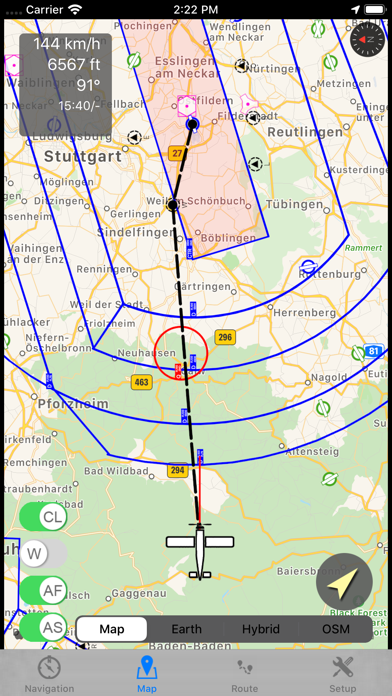
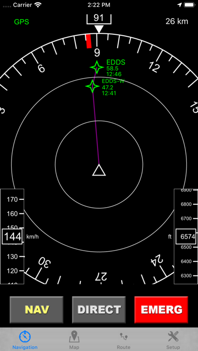
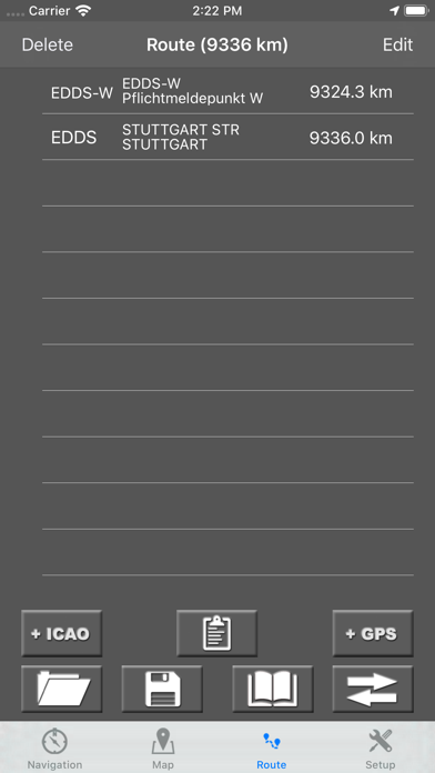
flyNav is a flight navigation app for VFR. Overview Features: - Moving map flight navigation with vector based maps - Airspaces for USA & Europe included - About 20.000 airfields & airports worldwide - Navaids VOR, DME, NDB for Europe - Supported devices: Apple iPhone, Apple iPad and Apple Watch - Easy-to-read Navigation Display - On-route weather & NOTAM information Detailed Feature: - Waypoints database with about 20.000 airfields & airports worldwide - Airspaces for USA, Canada, Germany, France, Italy, Swiss, Austria, Belgium, Hungary, Finnland,... - Moving map with vector based data (offline available!) - Navigation display with course and bearing indicator incl. waypoint distance and ETA - Altimeter with flight level support (using barometric sensor) - Plan a route directly in map via touch & drag - Automatic link of map orientation to airplane course - 5 minutes indicator - Manual route planner with ICAO & city search - Load & save routes - Automatic detection of take off time and touch down time - Track your flights via GPX - Emergency function: find nearest airfield and check if it's reachable - Import additional airspaces via openair format, e.g. traffic circuits - On-route NOTAM - On-route weather - Flight-log in PDF-format (printable & exportable) The handbook can be downloaded at http://www.flynav-app.com
Google Maps - Transit & Food

Shell

ViaBus

Moovit: Public Transport Live
Smart GPS Speedometer

Field Area & Maps Measure app

Radarbot: Speed Cameras & GPS

BTS SkyTrain

Share Location: Phone Tracker

Find my Phone, Friends - iMapp

Sygic GPS Navigation & Maps

Bolt Driver
GPS Digital Speed Tracker

Find my Phone - Family Locator

Coordinates - GPS Formatter
 PcMac ไทย
