
Dikirim oleh Walter Greger
Periksa Aplikasi atau Alternatif PC yang kompatibel
| App | Unduh | Peringkat | Diterbitkan oleh |
|---|---|---|---|
|
flyNav Flight Navigation
|
Dapatkan Aplikasi atau Alternatif ↲ | 2 1.50
|
Walter Greger |
Atau ikuti panduan di bawah ini untuk digunakan pada PC :
Pilih versi PC Anda:
Persyaratan Instalasi Perangkat Lunak:
Tersedia untuk diunduh langsung. Unduh di bawah:
Sekarang, buka aplikasi Emulator yang telah Anda instal dan cari bilah pencariannya. Setelah Anda menemukannya, ketik flyNav Flight Navigation di bilah pencarian dan tekan Cari. Klik flyNav Flight Navigationikon aplikasi. Jendela flyNav Flight Navigation di Play Store atau toko aplikasi akan terbuka dan itu akan menampilkan Toko di aplikasi emulator Anda. Sekarang, tekan tombol Install dan seperti pada perangkat iPhone atau Android, aplikasi Anda akan mulai mengunduh. Sekarang kita semua sudah selesai.
Anda akan melihat ikon yang disebut "Semua Aplikasi".
Klik dan akan membawa Anda ke halaman yang berisi semua aplikasi yang Anda pasang.
Anda harus melihat ikon. Klik dan mulai gunakan aplikasi.
Dapatkan APK yang Kompatibel untuk PC
| Unduh | Diterbitkan oleh | Peringkat | Versi sekarang |
|---|---|---|---|
| Unduh APK untuk PC » | Walter Greger | 1.50 | 1.51 |
Unduh flyNav Flight Navigation untuk Mac OS (Apple)
| Unduh | Diterbitkan oleh | Ulasan | Peringkat |
|---|---|---|---|
| $29.99 untuk Mac OS | Walter Greger | 2 | 1.50 |
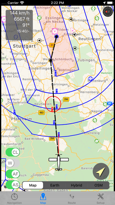
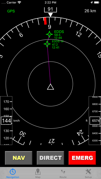
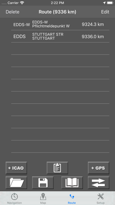
flyNav is a flight navigation app for VFR. Overview Features: - Moving map flight navigation with vector based maps - Airspaces for USA & Europe included - About 20.000 airfields & airports worldwide - Navaids VOR, DME, NDB for Europe - Supported devices: Apple iPhone, Apple iPad and Apple Watch - Easy-to-read Navigation Display - On-route weather & NOTAM information Detailed Feature: - Waypoints database with about 20.000 airfields & airports worldwide - Airspaces for USA, Canada, Germany, France, Italy, Swiss, Austria, Belgium, Hungary, Finnland,... - Moving map with vector based data (offline available!) - Navigation display with course and bearing indicator incl. waypoint distance and ETA - Altimeter with flight level support (using barometric sensor) - Plan a route directly in map via touch & drag - Automatic link of map orientation to airplane course - 5 minutes indicator - Manual route planner with ICAO & city search - Load & save routes - Automatic detection of take off time and touch down time - Track your flights via GPX - Emergency function: find nearest airfield and check if it's reachable - Import additional airspaces via openair format, e.g. traffic circuits - On-route NOTAM - On-route weather - Flight-log in PDF-format (printable & exportable) The handbook can be downloaded at http://www.flynav-app.com
Google Maps - Transit & Food

Waze Navigation & Live Traffic

KRL Access

Moovit: Public Transport Live

Qibla Finder, Qibla Compass AR

Schedules by Trafi

Parallel Space - Dual Multiple

iLocation: Here!

Find my Phone - Family Locator

Save Location GPS

Let It FLO

Spoten: Find my friends, kids

PARKEE

Avenza Maps: Offline Mapping

GPSPlus - GPS EXIF Editor
 PcMac Indonesia
