
에 의해 게시 NesTides
1. Ebro / Bruce Landing),Lost Lake Landing,Black Creek Landing ,Bozeman's Fish Camp,US Highway 331 Causeway Roadside Access Point #4,Cedar Log Landing (New),Bay Flats Recreation Area (Eglin AFB - Permit Required),Grassy Landing,Smokehouse Lake Landing (Private),Rooks Bluff Fish Camp,Rocky Creek Road 219 Put-In (Eglin AFB - Permit Required),Berrian Lake Landing ,Basin Bayou Camp Site,Cow Lake Landing ,Basin Creek Put-In (Eglin AFB - Permit Required),Seven Runs Canoe and Kayak Launch,Eden Gardens State Park Kayak Launch,Rocky Creek Road 200 Put-In (Eglin AFB - Permit Required),Crystal Lake (Chipley),Douglas Ferry - Billy Lee Park - Hinson Crossroads,Yates Mill Pond ,Pate Pond (Tobe Russ Dock),Boynton Cutoff Boat Landing,Strickland Landing Park and ,Live Oak Landing,Hightower Landing,Brunson Landing (Holmes Creek) ,Earl Gilbert Landing (Chipley),Griffin Landing (Gap Lake North),Gap Pond - Sunn...
2. Cora Long Landing),Savage Landing,Crews Lake Ramp,Rattlesnake Lake North Gravel ,Whitewater Lakes,Hammock Lake Primitive Boat Launch,Caryville ,Shell Landing (Holmes Creek),Pine Log Landing ,Fanning Branch (Two Creek) Park ,Spurling Landing Gravel ,River Run RV Resort,White Oak Landing (Porter Lake),Cotton Landing Canoe Launch (Holmes Creek),Rattlesnake Lake South Canoe Launch,Burnt Sock,Griffin Mill Pond ,Econfina Creek - Walsingham Park Canoe Launch,Econfina Creek - Canoe Livery (Privately Owned),Millers Ferry Bridge Pay Ramp (Unimproved Dirt Ramp),Don Cesar - St Pete Beach (Limited Parking),Park Boulevard ,A.L. Anderson Park,Sunset Beach Park - Sand Launch Beach (City Permit Required),John Chesnut Sr.
3. Park,Alligator Lake (Safety Harbor City Park),Clearwater Beach ,Walsingham Park Fish Management Area (No Motors),John S.
4. William Dallas Finch Landing),Little River Lake,Porter Lake Retreat ,Stewart Lake ,Vernon Park (C.E. Miller Landing) ,White Double Lake (aka.
5. "The ability to display real-time status of boat ramps allows me to extend fishing trips by choosing a boat ramp that is safe & fully functional.
6. The satellite view allows me to explore and discover new fishing grounds I never knew existed near those boat ramps.
7. Find a functional boat ramp and discover good fishing grounds with the Satellite Map all from one app.
8. Accurate, simple to use Satellite Map based Florida Boat Ramps of all FWC public boat ramps.
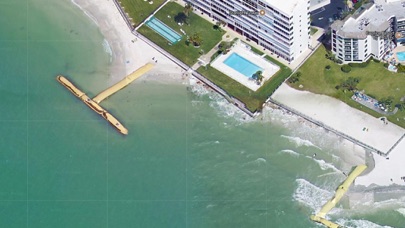
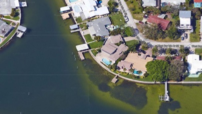
9. Included is the ability to zoom and view satellite imagery for fishing ground characteristics to compare with tide movement.
10. Auto saves your map location so you can return quickly the next time you use the boat ramp app.
11. Cowford and Park (aka.

또는 아래 가이드를 따라 PC에서 사용하십시오. :
PC 버전 선택:
소프트웨어 설치 요구 사항:
직접 다운로드 가능합니다. 아래 다운로드 :
설치 한 에뮬레이터 애플리케이션을 열고 검색 창을 찾으십시오. 일단 찾았 으면 Boat Ramp Florida 검색 막대에서 검색을 누릅니다. 클릭 Boat Ramp Florida응용 프로그램 아이콘. 의 창 Boat Ramp Florida Play 스토어 또는 앱 스토어의 스토어가 열리면 에뮬레이터 애플리케이션에 스토어가 표시됩니다. Install 버튼을 누르면 iPhone 또는 Android 기기 에서처럼 애플리케이션이 다운로드되기 시작합니다. 이제 우리는 모두 끝났습니다.
"모든 앱 "아이콘이 표시됩니다.
클릭하면 설치된 모든 응용 프로그램이 포함 된 페이지로 이동합니다.
당신은 아이콘을 클릭하십시오. 그것을 클릭하고 응용 프로그램 사용을 시작하십시오.
다운로드 Boat Ramp Florida Mac OS의 경우 (Apple)
| 다운로드 | 개발자 | 리뷰 | 평점 |
|---|---|---|---|
| $9.99 Mac OS의 경우 | NesTides | 3 | 2.33 |
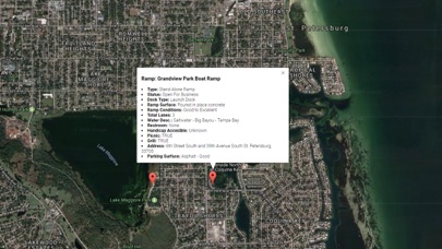
Accurate, simple to use Satellite Map based Florida Boat Ramps of all FWC public boat ramps. Designed by Florida Tournament fishermen and Professional Florda Fishing Guides. Find a functional boat ramp and discover good fishing grounds with the Satellite Map all from one app. NO SPAM ADS, SIMPLE TO USE...100% NO SPAM ADS. Features the most complete information about any Boat Ramp including: Dock Type Ramp Surface Ramp Conditions Waterway Type (Freshwater or Salt) Waterway Name Total Lanes Dock Type Parking Lot Surface Parking Lot Condition Trailer Restroom Handicap Access Picnic Lighting Grill Street, City, County, Zip Other Features: Auto saves your map location so you can return quickly the next time you use the boat ramp app. Excellent support for any issues, questions or new features...simply email: info@nestides.com and we'll show you how Apple support is meant to be. Included is the ability to zoom and view satellite imagery for fishing ground characteristics to compare with tide movement. Recent Feedback: "The ability to display real-time status of boat ramps allows me to extend fishing trips by choosing a boat ramp that is safe & fully functional. The satellite view allows me to explore and discover new fishing grounds I never knew existed near those boat ramps. Absolutely the best fishing software tool I have ever used. ," said USCG Captain Mike K. Partial list of FWC Florida Boat Ramps, see website for full list: Cowford and Park (aka. Ebro / Bruce Landing),Lost Lake Landing,Black Creek Landing ,Bozeman's Fish Camp,US Highway 331 Causeway Roadside Access Point #4,Cedar Log Landing (New),Bay Flats Recreation Area (Eglin AFB - Permit Required),Grassy Landing,Smokehouse Lake Landing (Private),Rooks Bluff Fish Camp,Rocky Creek Road 219 Put-In (Eglin AFB - Permit Required),Berrian Lake Landing ,Basin Bayou Camp Site,Cow Lake Landing ,Basin Creek Put-In (Eglin AFB - Permit Required),Seven Runs Canoe and Kayak Launch,Eden Gardens State Park Kayak Launch,Rocky Creek Road 200 Put-In (Eglin AFB - Permit Required),Crystal Lake (Chipley),Douglas Ferry - Billy Lee Park - Hinson Crossroads,Yates Mill Pond ,Pate Pond (Tobe Russ Dock),Boynton Cutoff Boat Landing,Strickland Landing Park and ,Live Oak Landing,Hightower Landing,Brunson Landing (Holmes Creek) ,Earl Gilbert Landing (Chipley),Griffin Landing (Gap Lake North),Gap Pond - Sunny Hills - Tanner Carter Landing,Tom Johns Landing (Porter Lake),Sand Landing - Lucas Lake (Unpaved),Lucas Lake (Jack Maddock Landing) ,John Elmer Carter Landing at Daniels Lake,Buster Rogers Primitive Boat Launch,Cedar Tree ,Dave Taylor Landing (Gin Lake),Brock Landing (Hicks Lake) ,Jenkins Landing ,Culpepper Landing (Holmes Creek) ,Litard Log (aka. William Dallas Finch Landing),Little River Lake,Porter Lake Retreat ,Stewart Lake ,Vernon Park (C.E. Miller Landing) ,White Double Lake (aka. Cora Long Landing),Savage Landing,Crews Lake Ramp,Rattlesnake Lake North Gravel ,Whitewater Lakes,Hammock Lake Primitive Boat Launch,Caryville ,Shell Landing (Holmes Creek),Pine Log Landing ,Fanning Branch (Two Creek) Park ,Spurling Landing Gravel ,River Run RV Resort,White Oak Landing (Porter Lake),Cotton Landing Canoe Launch (Holmes Creek),Rattlesnake Lake South Canoe Launch,Burnt Sock,Griffin Mill Pond ,Econfina Creek - Walsingham Park Canoe Launch,Econfina Creek - Canoe Livery (Privately Owned),Millers Ferry Bridge Pay Ramp (Unimproved Dirt Ramp),Don Cesar - St Pete Beach (Limited Parking),Park Boulevard ,A.L. Anderson Park,Sunset Beach Park - Sand Launch Beach (City Permit Required),John Chesnut Sr. Park,Alligator Lake (Safety Harbor City Park),Clearwater Beach ,Walsingham Park Fish Management Area (No Motors),John S. Taylor Park,Pinellas War Veterans Memorial Park - ,Maximo Park and ,Grandview Park ,Crisp Park ,Sunlit Cove Park,Gandy Wayside Park (Bad Condition - Small Boats Only),Fred Howard Park,Sutherland Bayou ,Lake Seminole Park and ,Coffee Pot Bayou ,Dunedin Causeway

Florida Tides & Fishing Regs

Gulf of Mexico Tide Tables

Southeastern Tidal Times

Chesapeake - Tidewater Tides

Northeast U.S.A. Tide Tables

네이버 지도, 내비게이션

카카오맵 - 대한민국 No.1 지도앱

TMAP - 내비게이션 / 지도

카카오버스
Google Maps

카카오내비

오일나우 - 유류세 인하 실시간 반영 중

카카오지하철

전국 스마트 버스 - 실시간 버스, 길찾기

지맵(Z-MAP)-제로페이, 가맹점 찾기, 모바일상품권

지하철 - 실시간 열차정보

모두의주차장 - 주차장찾기/주차할인/공유주차장

스마터치- 교통카드 필수 앱!

전국 시외버스 승차권 통합 예매(버스타고)

지하철 종결자 : Smarter Subway
 PcMac 한국어