
写的 - NesTides
1. Ebro / Bruce Landing),Lost Lake Landing,Black Creek Landing ,Bozeman's Fish Camp,US Highway 331 Causeway Roadside Access Point #4,Cedar Log Landing (New),Bay Flats Recreation Area (Eglin AFB - Permit Required),Grassy Landing,Smokehouse Lake Landing (Private),Rooks Bluff Fish Camp,Rocky Creek Road 219 Put-In (Eglin AFB - Permit Required),Berrian Lake Landing ,Basin Bayou Camp Site,Cow Lake Landing ,Basin Creek Put-In (Eglin AFB - Permit Required),Seven Runs Canoe and Kayak Launch,Eden Gardens State Park Kayak Launch,Rocky Creek Road 200 Put-In (Eglin AFB - Permit Required),Crystal Lake (Chipley),Douglas Ferry - Billy Lee Park - Hinson Crossroads,Yates Mill Pond ,Pate Pond (Tobe Russ Dock),Boynton Cutoff Boat Landing,Strickland Landing Park and ,Live Oak Landing,Hightower Landing,Brunson Landing (Holmes Creek) ,Earl Gilbert Landing (Chipley),Griffin Landing (Gap Lake North),Gap Pond - Sunn...
2. Cora Long Landing),Savage Landing,Crews Lake Ramp,Rattlesnake Lake North Gravel ,Whitewater Lakes,Hammock Lake Primitive Boat Launch,Caryville ,Shell Landing (Holmes Creek),Pine Log Landing ,Fanning Branch (Two Creek) Park ,Spurling Landing Gravel ,River Run RV Resort,White Oak Landing (Porter Lake),Cotton Landing Canoe Launch (Holmes Creek),Rattlesnake Lake South Canoe Launch,Burnt Sock,Griffin Mill Pond ,Econfina Creek - Walsingham Park Canoe Launch,Econfina Creek - Canoe Livery (Privately Owned),Millers Ferry Bridge Pay Ramp (Unimproved Dirt Ramp),Don Cesar - St Pete Beach (Limited Parking),Park Boulevard ,A.L. Anderson Park,Sunset Beach Park - Sand Launch Beach (City Permit Required),John Chesnut Sr.
3. Park,Alligator Lake (Safety Harbor City Park),Clearwater Beach ,Walsingham Park Fish Management Area (No Motors),John S.
4. William Dallas Finch Landing),Little River Lake,Porter Lake Retreat ,Stewart Lake ,Vernon Park (C.E. Miller Landing) ,White Double Lake (aka.
5. "The ability to display real-time status of boat ramps allows me to extend fishing trips by choosing a boat ramp that is safe & fully functional.
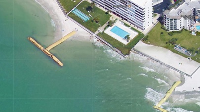
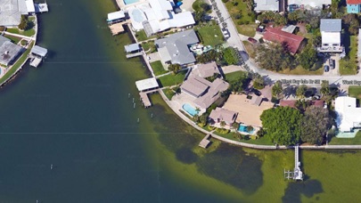
6. The satellite view allows me to explore and discover new fishing grounds I never knew existed near those boat ramps.
7. Find a functional boat ramp and discover good fishing grounds with the Satellite Map all from one app.
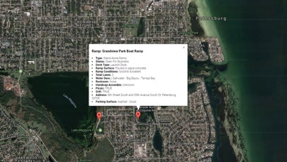
8. Accurate, simple to use Satellite Map based Florida Boat Ramps of all FWC public boat ramps.
9. Included is the ability to zoom and view satellite imagery for fishing ground characteristics to compare with tide movement.
10. Auto saves your map location so you can return quickly the next time you use the boat ramp app.
11. Cowford and Park (aka.

或按照以下指南在PC上使用 :
选择你的电脑版本:
软件安装要求:
可直接下载。下载如下:
现在,打开已安装的模拟器应用程序并查找其搜索栏。一旦找到它,请键入 Boat Ramp Florida 在搜索栏并按搜索。点击 Boat Ramp Florida应用程序图标。一个 窗口 Boat Ramp Florida 在Play商店或应用程序商店将打开并且它将在您的模拟器应用程序中显示商店。现在,按下安装按钮并像在iPhone或Android设备上一样,您的应用程序将开始下载。现在我们都完成了。
你会看到一个名为“所有应用程序”的图标。
点击它,它会带你到一个包含所有已安装应用程序的页面。
你应该看到 图标。点击它并开始使用该应用程序。
下载 Boat Ramp Florida 对于Mac OS (Apple)
| 下载 | 开发人员 | 评论 | 评分 |
|---|---|---|---|
| $9.99 对于Mac OS | NesTides | 3 | 2.33 |

Florida Tides & Fishing Regs

Gulf of Mexico Tide Tables

Southeastern Tidal Times

Chesapeake - Tidewater Tides

Northeast U.S.A. Tide Tables

高德地图-高德打车,导航公交地铁出行
百度地图-打车更快更优惠,智能导航和公交地铁
全球高清街景地图

腾讯地图-路线规划,导航打车出行必备
车来了-精准实时公交地铁,公共出行助手

掌上公交-精准实时公交车地铁查询
北斗导航-北斗三号全球卫星导航系统

北斗找人-守护家人出行安全
Google 地图

e高速 - ETC网上营业厅

奥维地图

北京公交-官方出品

Earth-地球
全国违章查询-交通车辆违章查询助手

WiFi密码查看器-WiFi密码一键查看!
 PcMac China