
投稿者 NesTides
1. OCEAN CITY (FISHING PIER),Ocean City Inlet,Ocean City (Isle of Wight Bay),Keydash, Isle of Wight Bay,Assateague Beach, Toms Cove,Harbor of Refuge,Chincoteague Channel (south end),Wishart Point, Bogues Bay,Chincoteague Island, USCG Station,Chincoteague Island, Lewis Creek,Chincoteague Island, Oyster Bay,Chincoteague Island, Blake Cove,Jesters Island,Franklin City,Buntings Bridge,Public Landing,South Point, Sinepuxent Neck,Saxis, Starling Creek, Pocomoke Sound,Ape Hole Creek, Pocomoke Sound,Shelltown,Snowhill, city park,Crisfield, Little Annemessex River,Colburn Creek, Big Annemessex River,Long Point, Big Annemessex River,Teague Creek, Manokin River,Ewell, Smith Island,Holland Island Bar Light,Chance,Sharkfin Shoal Light,Great Shoals Light, Monie Bay,Whitehaven,Salisbury,Roaring Point,Vienna,Sharptown,McCreedy's Creek, Fishing Bay,Hooper Strait Light,Bishops Head, Hooper Strait,Middle Hoop...
2. Michaels, Miles River,Kent Island Narrows,Love Point,Queenstown,Centreville Landing, Corsica River,Cliffs Point,Cliffs Wharf,Chestertown,Crumpton,Matapeake, Kent Island,Kent Point Marina,Deep Landing, Swan Creek,Tolchester Beach,Worton Creek entrance,Sassafras River, Betterton,Town Point Wharf,Old Frenchtown Wharf,Charlestown, Northeast River,Havre de Grace,Port Deposit,Pond Point, Bush River,North Point,Stony Creek,Hawkins Point,BALTIMORE, Fort McHenry,Fort McHenry Marsh,Mountain Point, Magothy River,Cornfield Creek, Magothy River,Brewer Point,Annapolis (US Naval Academy),Thomas Point Shoal Light,Edgewater, South River,Gingerville Creek, South River,Rhode River (County Wharf),Galesville, West River,Rose Haven,Chesapeake Beach,Long Beach,Cove Point,Solomons Island,Broomes Island,Benedict,Md.,Colonial Beach, Va.,Dahlgren, Upper Machodoc Creek, Va.,Lower Cedar Point, Md.,Mathias Point, Va....
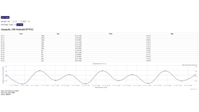
3. Advanced tide graphs allow for you to judge the level of water movement for optimal fishing between high and low tide in Maryland between tide stations so you can follow the tide flow for the entire day.
4. "NesTides ability to display tide predictions and actual tidal flow graphs allow me to extend fishing trips by following different tide station tide charts and moving with the tide flow.
5. Ability to forecast Maryland tides from NOAA by setting date and period for any of the tidal stations for the entire State of Maryland tide tables.
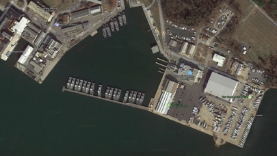
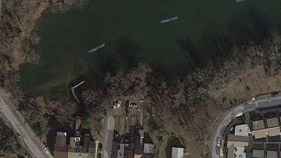
6. Included is the ability to zoom and view satellite imagery for fishing ground characteristics to compare with tide movement.
7. Accurate, simple to use Satellite Map based Maryland tide charts of the all NOAA based Maryland tide stations on a simple to use satellite map.
8. Michaels, San Domingo Creek,Avalon, Claiborne, Eastern Bay,St.
9. Auto-save last location for easy reference to your last tide station the next time you use the tide app.
10. The satellite view allows me to explore and discover new fishing grounds I never knew existed.
11. Designed by Maryland fishermen and Professional Maryland Fishing Guides.

互換性のあるPCアプリまたは代替品を確認してください
| 応用 | ダウンロード | 評価 | 開発者 |
|---|---|---|---|
|
Maryland Tide Chart & Weather
|
アプリまたは代替を取得 ↲ | 6 4.33
|
NesTides |
または、以下のガイドに従ってPCで使用します :
PCのバージョンを選択してください:
ソフトウェアのインストール要件:
直接ダウンロードできます。以下からダウンロード:
これで、インストールしたエミュレータアプリケーションを開き、検索バーを探します。 一度それを見つけたら、 Maryland Tide Chart & Weather を検索バーに入力し、[検索]を押します。 クリック Maryland Tide Chart & Weatherアプリケーションアイコン。 のウィンドウ。 Maryland Tide Chart & Weather - Playストアまたはアプリストアのエミュレータアプリケーションにストアが表示されます。 Installボタンを押して、iPhoneまたはAndroidデバイスのように、アプリケーションのダウンロードが開始されます。 今私達はすべて終わった。
「すべてのアプリ」というアイコンが表示されます。
をクリックすると、インストールされているすべてのアプリケーションを含むページが表示されます。
あなたは アイコン。 それをクリックし、アプリケーションの使用を開始します。
ダウンロード Maryland Tide Chart & Weather Mac OSの場合 (Apple)
| ダウンロード | 開発者 | レビュー | 評価 |
|---|---|---|---|
| $9.99 Mac OSの場合 | NesTides | 6 | 4.33 |

Florida Tides & Fishing Regs

Gulf of Mexico Tide Tables

Southeastern Tidal Times

Chesapeake - Tidewater Tides

Northeast U.S.A. Tide Tables

ウェザーニュース

Yahoo!天気

頭痛ーる

tenki.jp -日本気象協会の天気予報専門アプリ-

Yahoo!防災速報

Windy.com

特務機関NERV防災

タイドグラフBI /全国の釣り場ごとの潮見表

真の温度計

温度計++

湿度計

ゆれくるコール

Windy.app: 天気予報 - 風予報、風速

アメフリ

アメミル
 PcMac 日本語