
Pubblicato da NesTides
1. OCEAN CITY (FISHING PIER),Ocean City Inlet,Ocean City (Isle of Wight Bay),Keydash, Isle of Wight Bay,Assateague Beach, Toms Cove,Harbor of Refuge,Chincoteague Channel (south end),Wishart Point, Bogues Bay,Chincoteague Island, USCG Station,Chincoteague Island, Lewis Creek,Chincoteague Island, Oyster Bay,Chincoteague Island, Blake Cove,Jesters Island,Franklin City,Buntings Bridge,Public Landing,South Point, Sinepuxent Neck,Saxis, Starling Creek, Pocomoke Sound,Ape Hole Creek, Pocomoke Sound,Shelltown,Snowhill, city park,Crisfield, Little Annemessex River,Colburn Creek, Big Annemessex River,Long Point, Big Annemessex River,Teague Creek, Manokin River,Ewell, Smith Island,Holland Island Bar Light,Chance,Sharkfin Shoal Light,Great Shoals Light, Monie Bay,Whitehaven,Salisbury,Roaring Point,Vienna,Sharptown,McCreedy's Creek, Fishing Bay,Hooper Strait Light,Bishops Head, Hooper Strait,Middle Hoop...
2. Michaels, Miles River,Kent Island Narrows,Love Point,Queenstown,Centreville Landing, Corsica River,Cliffs Point,Cliffs Wharf,Chestertown,Crumpton,Matapeake, Kent Island,Kent Point Marina,Deep Landing, Swan Creek,Tolchester Beach,Worton Creek entrance,Sassafras River, Betterton,Town Point Wharf,Old Frenchtown Wharf,Charlestown, Northeast River,Havre de Grace,Port Deposit,Pond Point, Bush River,North Point,Stony Creek,Hawkins Point,BALTIMORE, Fort McHenry,Fort McHenry Marsh,Mountain Point, Magothy River,Cornfield Creek, Magothy River,Brewer Point,Annapolis (US Naval Academy),Thomas Point Shoal Light,Edgewater, South River,Gingerville Creek, South River,Rhode River (County Wharf),Galesville, West River,Rose Haven,Chesapeake Beach,Long Beach,Cove Point,Solomons Island,Broomes Island,Benedict,Md.,Colonial Beach, Va.,Dahlgren, Upper Machodoc Creek, Va.,Lower Cedar Point, Md.,Mathias Point, Va....
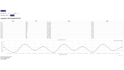
3. Advanced tide graphs allow for you to judge the level of water movement for optimal fishing between high and low tide in Maryland between tide stations so you can follow the tide flow for the entire day.
4. "NesTides ability to display tide predictions and actual tidal flow graphs allow me to extend fishing trips by following different tide station tide charts and moving with the tide flow.
5. Ability to forecast Maryland tides from NOAA by setting date and period for any of the tidal stations for the entire State of Maryland tide tables.
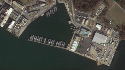
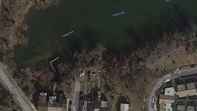
6. Included is the ability to zoom and view satellite imagery for fishing ground characteristics to compare with tide movement.
7. Accurate, simple to use Satellite Map based Maryland tide charts of the all NOAA based Maryland tide stations on a simple to use satellite map.
8. Michaels, San Domingo Creek,Avalon, Claiborne, Eastern Bay,St.
9. Auto-save last location for easy reference to your last tide station the next time you use the tide app.
10. The satellite view allows me to explore and discover new fishing grounds I never knew existed.
11. Designed by Maryland fishermen and Professional Maryland Fishing Guides.

Controlla app per PC compatibili o alternative
| App | Scarica | la Valutazione | Sviluppatore |
|---|---|---|---|
|
Maryland Tide Chart & Weather
|
Ottieni app o alternative ↲ | 6 4.33
|
NesTides |
Oppure segui la guida qui sotto per usarla su PC :
Scegli la versione per pc:
Requisiti per l'installazione del software:
Disponibile per il download diretto. Scarica di seguito:
Ora apri l applicazione Emulator che hai installato e cerca la sua barra di ricerca. Una volta trovato, digita Maryland Tide Chart & Weather nella barra di ricerca e premi Cerca. Clicca su Maryland Tide Chart & Weathericona dell applicazione. Una finestra di Maryland Tide Chart & Weather sul Play Store o l app store si aprirà e visualizzerà lo Store nella tua applicazione di emulatore. Ora, premi il pulsante Installa e, come su un iPhone o dispositivo Android, la tua applicazione inizierà il download. Ora abbiamo finito.
Vedrai un icona chiamata "Tutte le app".
Fai clic su di esso e ti porterà in una pagina contenente tutte le tue applicazioni installate.
Dovresti vedere il icona. Fare clic su di esso e iniziare a utilizzare l applicazione.
Ottieni un APK compatibile per PC
| Scarica | Sviluppatore | la Valutazione | Versione corrente |
|---|---|---|---|
| Scarica APK per PC » | NesTides | 4.33 | 1.0 |
Scarica Maryland Tide Chart & Weather per Mac OS (Apple)
| Scarica | Sviluppatore | Recensioni | la Valutazione |
|---|---|---|---|
| $9.99 per Mac OS | NesTides | 6 | 4.33 |

Florida Tides & Fishing Regs

Gulf of Mexico Tide Tables

Southeastern Tidal Times

Chesapeake - Tidewater Tides

Northeast U.S.A. Tide Tables

Meteo - by iLMeteo.it

3B Meteo - Previsioni Meteo

Meteo & Radar

Real termometro

Meteo Aeronautica

Meteo.it - Previsioni Meteo

Termometro++

Windy.com

MeteoSwiss

Termometro digitale

Clime: Radar Meteo Live

CARROT Weather

Skiinfo

Windy: Meteo, vento, onde mare

@Termometro
 PcMac Italiano