
写的 - Josue V. Herrera
1. - Visual guidance (a cute little ball) that moves around the compass and always points to the geographical coordinates where the hike started.
2. - A graphical comparison between all your saved walks, segmented in the last seven days, the current month and a custom date range you can choose.
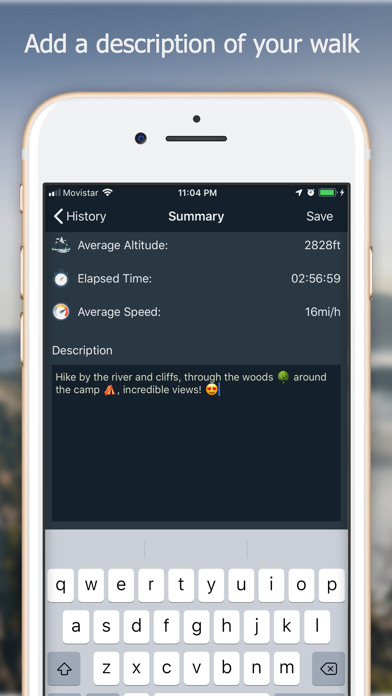
3. - When the hike is over the app shows you a summary of your walk, where you can add a description and choose to save it or not.
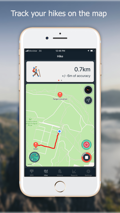
4. - You can load a hike and visualize it in the map (at the Hike tab) including the distance traveled and rest of information.
5. - Touching a map annotation shows the coordinates for that location with the option to share it with apps like Waze, Google Map, or just plain text.
6. - A summary of the distance and top altitude you have covered and reach during your saved hikes.
7. - You can delimiter your hike inside a circular safe zone, and the app warns you when you enter or exit this zone.
8. - You can choose from two of the available algorithms used to measure the distance covered during your hikes.
9. Navstar process and segment the raw data your device (GPS receiver) is getting from the satellite network.
10. - You can edit a hike and change the associated description.
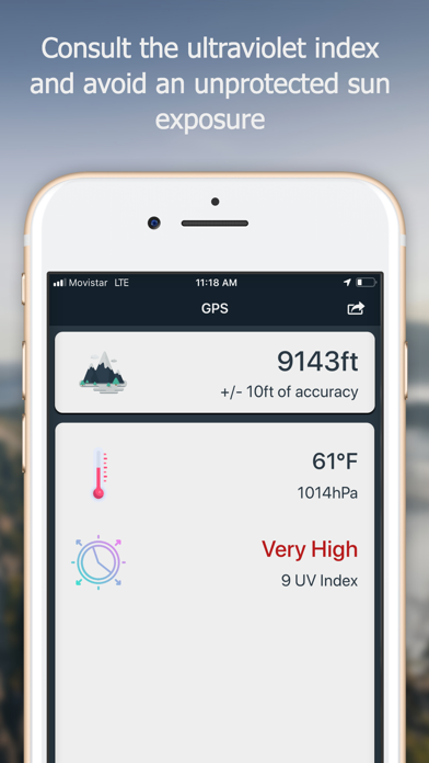
11. - You can take a screenshot of your current altitude and location.

或按照以下指南在PC上使用 :
选择你的电脑版本:
软件安装要求:
可直接下载。下载如下:
现在,打开已安装的模拟器应用程序并查找其搜索栏。一旦找到它,请键入 Navstar - GPS & Map for Hikers 在搜索栏并按搜索。点击 Navstar - GPS & Map for Hikers应用程序图标。一个 窗口 Navstar - GPS & Map for Hikers 在Play商店或应用程序商店将打开并且它将在您的模拟器应用程序中显示商店。现在,按下安装按钮并像在iPhone或Android设备上一样,您的应用程序将开始下载。现在我们都完成了。
你会看到一个名为“所有应用程序”的图标。
点击它,它会带你到一个包含所有已安装应用程序的页面。
你应该看到 图标。点击它并开始使用该应用程序。
下载 Navstar 对于Mac OS (Apple)
| 下载 | 开发人员 | 评论 | 评分 |
|---|---|---|---|
| $5.99 对于Mac OS | Josue V. Herrera | 0 | 1 |

高德地图-高德打车,导航公交地铁出行

百度地图-打车更快更优惠,智能导航和公交地铁
全球高清街景地图

腾讯地图-路线规划,导航打车出行必备

车来了-精准实时公交地铁,公共出行助手

掌上公交-精准实时公交车地铁查询
北斗导航-北斗三号全球卫星导航系统

北斗找人-守护家人出行安全
Google 地图

e高速 - ETC网上营业厅

奥维地图

北京公交-官方出品

Earth-地球

全国违章查询-交通车辆违章查询助手

WiFi密码查看器-WiFi密码一键查看!
 PcMac China