Published by Luis Meloni on 2021-11-27
What is eWAC SUL?
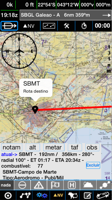
This app allows you to use your iPhone or iPad as an aeronautical GPS and practical EFB, on the ground or in flight, with the World Aeronautical Chart (WAC), ENR L and H, among others, as your terrain view, within the rules of IS 91-002. The app shows your position on the WAC/other charts and provides information such as latitude, longitude, speed, altitude, course, as well as nearby aerodromes, helipads, fixes, or cities and towns. The orientation of the WAC and other charts can be set in six different ways, and all information changes dynamically with your position.
1. O Aplicativo mostra sua posição na WAC / outras cartas e informa latitude, longitude, velocidade, altitude, curso, bem como os aeródromos, helipontos, fixos ou cidades e vilas próximos da sua posição atual.
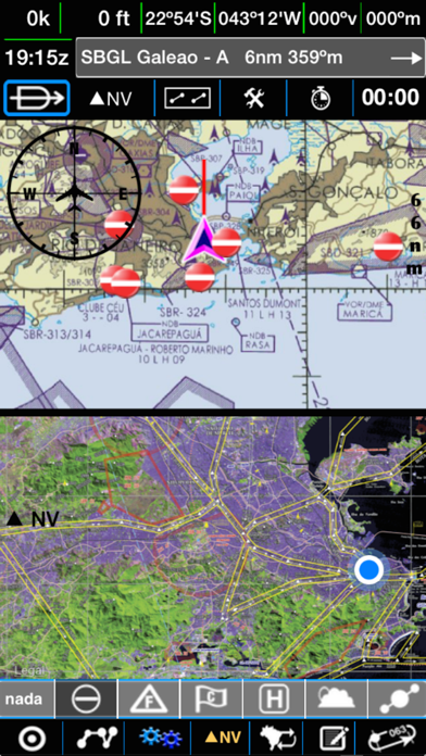
2. Mostre dois mapas na mesma tela, veja sua posição simultaneamente nas Rotas especiais de Aeronaves e de Helicopteros ou na WAC e nas REAs ou Cartas de Rota.
3. Alem das informações internas dos aeródromos, helipontos , fixos IFR, fixos de corredores visuais e cidades, você poderá cadastrar qualquer coordenada desejada, via digitação ou com um toque na tela.
4. Na versão iPad inverta a cor destas cartas (negativo) e poderá, consultando a carta fazer facilmente goto ou incluir fixos de aproximação final ou saída na sua rota.
5. Você poderá, por exemplo, voar sempre visualizando os aeródromos próximos da sua posição atual e manter a sua posição centralizada no mapa.
6. A orientação da WAC e demais cartas pode ser feita de 6 formas diferentes: norte verdadeiro, norte magnético, heading up, goto UP, destino UP ou girando para qualquer angulo que quiser.
7. Mude a orientação do aparelho, veja a direção a seguir, mude o mapa desejado, centralize o mapa e acompanhe a escala do mesmo, mude o mapa atual, veja o mapa apontando para uma das 6 orientações disponíveis.
8. Faça GOTO para um ponto, defina / salve / inverta e recupere uma ROTA via digitação ou por toque na tela.
9. Modifique vários parâmetros do app, veja o alcance de sua aeronave com o combustível atual, veja o ETE, ETA / Distancia para o próximo ponto e destino com um mini painel de GPS.
10. Consulte automaticamente ou a qualquer momento o METAR e TAF dos aeródromos próximos de sua posição e daqueles definidos na sua ROTA.
11. Use a função GOTO para indicar a distancia e curso para uma posição : fixo ou aeródromo / heliponto ou ponto do usuário.
12. Liked eWAC SUL? here are 5 Navigation apps like Kıble Pusulası; RE/MAX Results - Results Radar; eWAC NORTE; Google Maps;
Or follow the guide below to use on PC:
Select Windows version:
Install eWAC SUL app on your Windows in 4 steps below:
Download a Compatible APK for PC
| Download | Developer | Rating | Current version |
|---|---|---|---|
| Get APK for PC → | Luis Meloni | 4.90 | 5.6.11 |
Download on Android: Download Android
- Displays position on WAC/other charts and provides various information
- Orientation of charts can be set in six different ways
- Shows nearby aerodromes, helipads, fixes, or cities and towns
- Allows users to add desired coordinates via typing or touch
- Allows users to set/save/invert/retrieve a route via typing or touch
- Calculates estimated consumption and other information for each leg of the route
- Contains complete information of ROTAER of Brazilian aerodromes and helipads, and major ones worldwide
- Allows users to modify various app parameters and view the range of their aircraft with current fuel
- Allows users to activate a directional gyro connected to GOTO to see heading and radial
- Allows users to show two maps on the same screen and view their position simultaneously on special aircraft and helicopter routes or on WAC and REAs or Route Charts
- Contains all Brazilian WAC charts and visual corridors
- Allows users to add georeferenced maps and charts, internal and external checklists, alarms, and flight logs
- Allows users to change the orientation of the device, change the desired map, centralize the map, and follow its scale
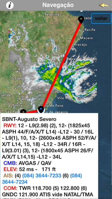
- Allows users to view navigation on the wind chart at various levels, on the GOES or Aeris satellite (requires internet access)
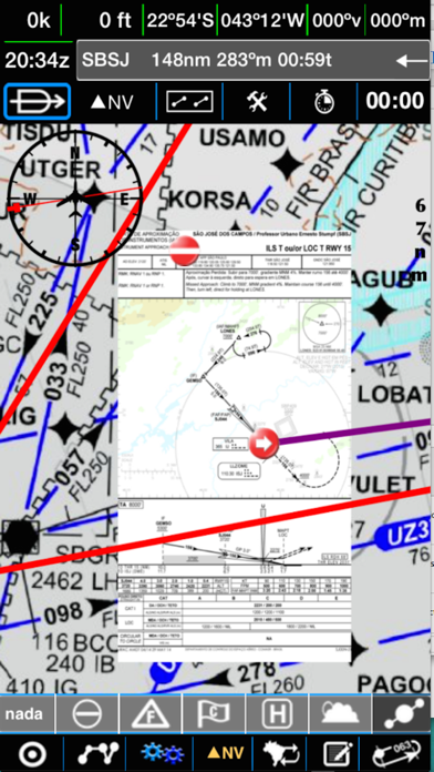
- Allows users to load desired aerodrome charts for consultation in flight: ADC, VAC, SID, and IAC
- Allows users to consult METAR and TAF automatically or at any time for nearby aerodromes and those defined in their route
- Allows users to create and operate their aircraft checklists in an audio-visual way and set alarms to help in various stages of flight
- Must be used within the rules of ANAC and DECEA.
Great application
WAC Sul Norte
App funcionando normalmente!!!
Top!
 PC Apps