Published by TAK Product Center on 2025-03-28
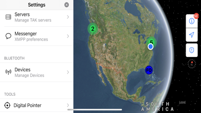
What is iTAK? The Team Awareness Kit (TAK) application, also known as the Tactical Assault Kit in the Department of Defense, is a collaborative geospatial app that allows users to see their team's locations, sensor information, videos, chat, and more in real-time. It supports DoD and commercial sector standards for icons, sensor information, and communication. The app can be used for law enforcement, first responders, hunting, fishing, ornithology, wildlife site survey, and more.
1. iTAK supports Department of Defense (DoD) and commercial sector standards for icons, sensor information, and communication.
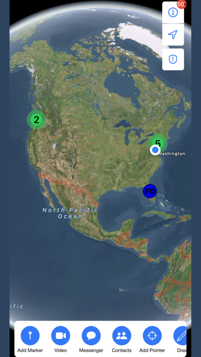
2. iTAK is a collaborative geospatial application to see your teams’ locations, sensor information, videos, chat, and more in real-time.
3. Data can be pre-loaded into iTAK or downloaded from the network (via TAK Server) when available.
4. Liked iTAK? here are 5 Navigation apps like Google Maps; Waze Navigation & Live Traffic; ParkMobile - Find Parking; Transit • Subway & Bus Times; SpotHero: #1 Rated Parking App;
Or follow the guide below to use on PC:
Select Windows version:
Install iTAK app on your Windows in 4 steps below:
Download a Compatible APK for PC
| Download | Developer | Rating | Current version |
|---|---|---|---|
| Get APK for PC → | TAK Product Center | 3.73 | 2.11.1 |
Get iTAK on Apple macOS
| Download | Developer | Reviews | Rating |
|---|---|---|---|
| Get Free on Mac | TAK Product Center | 122 | 3.73 |
Download on Android: Download Android
- Online and offline mapping (most standard formats)
- Blue force/team tracking (BFT)
- Collaborative mapping, including points, drawings, locations of interest
- Import and display of KML, KMZ, GeoPDF overlays
- Location marking, sharing, with photo tagging
- Chat, file sharing, photo sharing
- Live video streaming with the ability to share video links
- Spotted map to mark and share multiple locations across your map
- Digital pointer to rapidly mark and share items on the map with your team
- Navigation-walking/hiking, driving, also useful flying and air-ground coordination
- Center on self or other objects (e.g. another person in the network)
- Range, bearing measurement tools
- Team Emergency Beacons
- Customizable toolbar
- 3D perspective
- All data is secured and fully compatible with the TAK ecosystem (ATAK, TAK Server, WinTAK)
- Upcoming features/enhancements include full backwards compatibility with TAK Geochat and TAK Datasync, and full support for all icon sets currently available in ATAK.
- System requirements: iOS version 14.1 and later.
 PC Apps