Last Updated by Beidou Hanglu Technology Co.,Ltd. on 2025-03-25


What is Earth-地球?
Earth-地球 is a satellite map application developed by Beidou Navigation Company and operated by Chuangshi Thread. It is designed to replace the domestic versions of Google Earth and Google Maps, and can meet the needs of various industries for geographic surveying and 3D terrain viewing.
Getting the best Navigation app for you is hard, which is why we are happy to give you Earth-地球 from Beidou Hanglu Technology Co.,Ltd.. this app-地球是北斗航路公司开发,创世线程运营的地球卫星地图应用,用于代替谷歌地球和google地球、google earth的国内版本,可满足各行业对地理测绘3D查看地形的需求。 卫星图层和路网导航图: 集成了谷歌地图、google地图、混合图、天地图、百度API、百度街景、高德POI、Arcgis速度比传统奥维互动地图更快更清晰; 经纬度: 可输入经纬度快速定位至街景地面无需使用ourplay或者谷歌空间; 夜间模式: 夜间模式可观察地球的夜景; 卫星导航: 通过指南针可矫正定位的卫星导航找到家乡家里的屋顶; 海量数据: 全球历史影像数据单一年份的高清地图数据为70TB,大数据支持谷歌空间; 轨迹: 定位时将体验飞行轨迹落到世界地图的表面; 未来将添加后续将可提交CAD文件,导航定位,进行测量等GPS工具箱功能,一起看地图功能,气象数据、洋流、查看好友位置、罗盘等GIS地球仪功能;. If Earth-地球 suits you, get the 44.87 MB app for 2.0.8 on PC. IF you like Earth-地球, you will like other Navigation apps like Pocket Earth PRO; Live Earth Map HD - Live Cam; Earth Maps; Magic Earth Navigation & Maps; Satellite Map - Live Earth;
GET Compatible PC App
| App | Download | Rating | Maker |
|---|---|---|---|
 Earth-地球 Earth-地球 |
Get App ↲ | 241 4.48 |
Beidou Hanglu Technology Co.,Ltd. |
Or follow the guide below to use on PC:
Select Windows version:
Install Earth-地球 app on your Windows in 4 steps below:
Download a Compatible APK for PC
| Download | Developer | Rating | Current version |
|---|---|---|---|
| Get APK for PC → | Beidou Hanglu Technology Co.,Ltd. | 4.48 | 2.0.8 |
Get Earth-地球 on Apple macOS
| Download | Developer | Reviews | Rating |
|---|---|---|---|
| Get Free on Mac | Beidou Hanglu Technology Co.,Ltd. | 241 | 4.48 |
Download on Android: Download Android
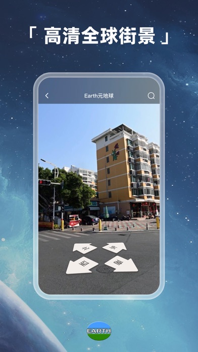
- Satellite and road network navigation maps: integrates Google Maps, Google Earth, mixed maps, Tianditu, Baidu API, Baidu Street View, Amap POI, and Arcgis, with faster and clearer speed than traditional Aovi interactive maps.
- Latitude and longitude: allows for quick location to street view without using Ourplay or Google Space.
- Night mode: allows for viewing of the Earth's night scene.
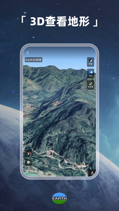
- Satellite navigation: uses a compass to correct positioning and find the roof of one's home.
- Massive data: supports Google Space with 70TB of high-definition map data for a single year of global historical image data.
- Trajectory: experience flight trajectory landing on the surface of the world map during positioning.
- Future updates will include GPS toolbox functions such as submitting CAD files, navigation positioning, measurement, and viewing maps together, as well as GIS globe functions such as meteorological data, ocean currents, viewing friend locations, and compass.
 PC Apps