Published by Loongship Technology Co.,Ltd. on 2021-04-28
What is Vesselink-船达通?
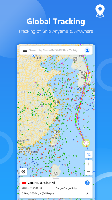
The Vesselink app is a comprehensive ship tracking and management tool that provides users with access to global near real-time satellite and terrestrial AIS data. The app offers features such as ship tracking, ship search, historical track, voyage information, nautical chart, marine meteorological data, notifications, and fleet management. The app is designed to help users track and manage ships, analyze ship data, and make informed decisions.
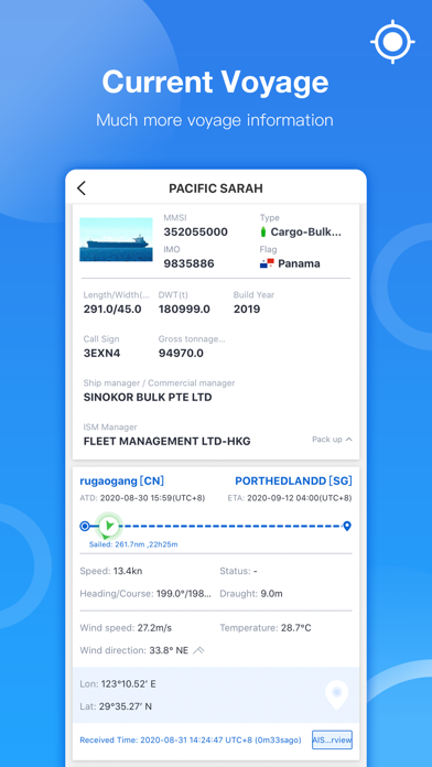
1. • Ship details view, ship type, draft, speed, tonnage etc.
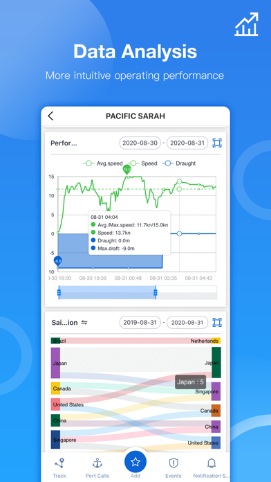
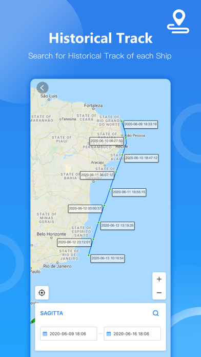
2. • Search for nearly 30 days of historical track for each ship.
3. • Comprehensive analysis of speed and course during the period.
4. Liked Vesselink-船达通? here are 5 Navigation apps like Google Maps; Waze Navigation & Live Traffic; ParkMobile - Find Parking; Transit • Subway & Bus Times;
GET Compatible PC App
| App | Download | Rating | Maker |
|---|---|---|---|
 Vesselink-船达通 Vesselink-船达通 |
Get App ↲ | 52 4.27 |
Loongship Technology Co.,Ltd. |
Or follow the guide below to use on PC:
Select Windows version:
Install Vesselink-船达通 app on your Windows in 4 steps below:
Download a Compatible APK for PC
| Download | Developer | Rating | Current version |
|---|---|---|---|
| Get APK for PC → | Loongship Technology Co.,Ltd. | 4.27 | 2.3.1 |
Get Vesselink-船达通 on Apple macOS
| Download | Developer | Reviews | Rating |
|---|---|---|---|
| Get Free on Mac | Loongship Technology Co.,Ltd. | 52 | 4.27 |
Download on Android: Download Android
- Ship Tracking: Access to more than 300,000 AIS data online per day, ship details view, ship type, draft, speed, tonnage, ship data analysis, performance analysis, operating efficiency, event risk.
- Search for Ships: Search ships by name, IMO, MMSI, call sign.
- Ships Filter: Select ships based on ship type, navigation status, ship length, deadweight, and year of construction.
- Historical Track: Search for nearly 30 days of historical track for each ship, comprehensive analysis of speed and course during the period.
- Voyage Information: Navigational status and departure information of each ship, origin & destination port information, ETA, route, and time of port call for each ship.
- Nautical Chart: Pilotage information such as sea bed, sea marks, and landmarks, port details such as berths, dry docks, and terminal location, position and characteristics of buoys, lights, lighthouses, depths of water, and heights of land.
- Marine Meteorological: Wind, wave, pressure, current, visibility, global weather forecast for the next 5 days, global typhoons & storms, Wind Circles, Actual Paths, Forecast Paths.
- Notifications: Port arrival & departure notifications, anchoring, berthing, voyage dynamic notifications, including draft changes, destination changes, ETA changes, typhoon notifications, avoiding typhoon for ships, area notifications, ship in and out of areas (HRA, JWC, etc.).
- Fleet Management: Add concerned/managed ships to the fleet list, the position of ships in the fleet are shown on the map in near real-time.
- Function Integration: Store main function entrances into a menu bar to make the page more concise.
- Contact us: Email: info@vesselink.com. If you have any suggestions or complaints, welcome to let us know by phone, email, or comment area.
- Provides good information about ship positions
- Has some good features when they work
- Works well for ships
- Slow to update ship's position
- Sometimes off by days
- Does not work well for pleasure boats transmitting their positions
- Users have reported issues with confirmation emails and advanced features
Not sure
Some bugs
Great
Not for Yachts
 PC Apps