Published by Jean-Marc Meyer on 2021-10-24
What is eVario?
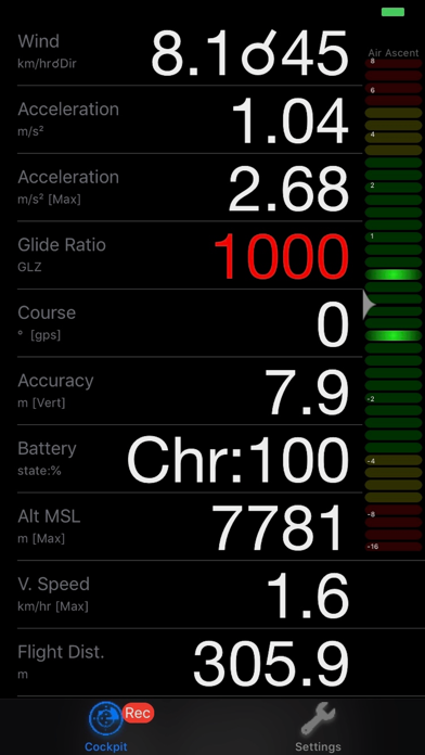
eVario is a connected flight navigation app that provides real-time information of a variometer like altimeter, speedometer, odometer, chronometer, gyrometer, anemometer for every (air)craft pilot. It is a 9-axis measurement (accelerometer, gyrometer, gps), barometer assisted, connected and intuitive instrument with a polychrom display. The app is mainly designed for paragliding/hang-gliding, but may be used as well while biking, hiking, running, sailing, skiing, flying, etc. It is optimised for low battery usage and lets you plan ahead, plan landing, take off, stay in control, thermalling, be efficient, find landing, review track, manage logbook, and do more.
1. eVario is your connected flight navigation companion during and after your adventure trip, helping you to visualise relevant data, assist you while progressing in the air by returning visual and acoustical feedback.
2. The integrated data logger automatically records your 3D location and provides the recorded track file to e.g. your iCloud Drive for track visualisation or flight metrics.
3. eVario is a 9-axis measurement (accelerometer, gyrometer, gps), barometer assisted, connected and intuitive instrument with a polychrom display, exploiting the embedded device’s hardware and accurate sensoric, without need to connect external devices.
4. ▶ MANAGE LOGBOOK: Access each individual track record time stamped file, synchronise them with your iCloud.
5. ▶ REVIEW TRACK: Visualise the past track on 4 map styles or show the track elevation profile graph in animated or interactive mode.
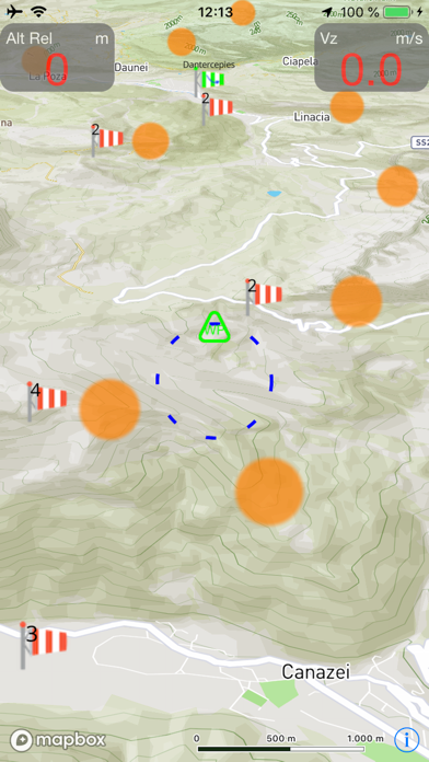
6. ▶ BE EFFICIENT: Track wind estimation, direction and force, to soar or prepare your landing.
7. ▶ TAKE OFF: Automatic track recording is taking place in background and take-off altitude is referenced.
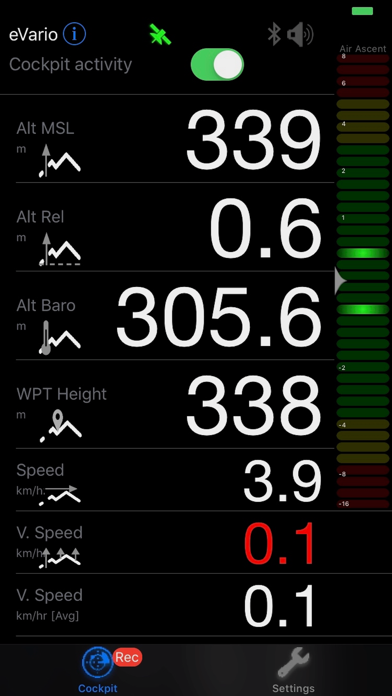
8. It typically provides real time information of a variometer like altimeter, speedometer, odometer, chronometer, gyrometer, anemometer for every (air)craft pilot.
9. Its configurable cockpit allows you to keep track of the most relevant to you.
10. ▶ TOUCH&GO: Turn on & Go fly! The cockpit shows real-time data after a short automatic instrument calibration.
11. ▶ THERMALLING: Get acoustical and visual feedback of the encountered thermals and easily locate them when returning back.
12. Liked eVario? here are 5 Sports apps like theVariometer; ESPN: Live Sports & Scores; ESPN Fantasy Sports & More; GameChanger Classic;
Or follow the guide below to use on PC:
Select Windows version:
Install eVario - Variometer Pro app on your Windows in 4 steps below:
Download a Compatible APK for PC
| Download | Developer | Rating | Current version |
|---|---|---|---|
| Get APK for PC → | Jean-Marc Meyer | 4.00 | 1.21.0 |
Get eVario on Apple macOS
| Download | Developer | Reviews | Rating |
|---|---|---|---|
| Get $10.99 on Mac | Jean-Marc Meyer | 6 | 4.00 |
Download on Android: Download Android
- Clear dashboard of digital real-time data
- Advanced interactive cockpit with configurable measurement field display
- Access a large number of settings directly impacting sensoric, display, acoustic or interaction
- Unlimited GPS tracks and waypoints saves
- Support of metric and imperial unit system
- Support of GPX/IGC record formats
- Automatic tracking start/stop upon movement detection
- Automatic GPS track recording
- Logbook with individual 3D GPS track records (timestamp, latitude, longitude, elevation) supporting derived data analysis
- Manage/Share track files from within integrated file browser
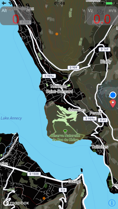
- Visualise your position, track line, thermal hotspots, sites, weather data on map
- Map enhancement by overlaid instruments like altitude, speed or ascent
- Map style selection: choose from 4 styles including terrain (dark/bright), topo and satellite
- Offline map downloads worldwide! Including topographic data, peak names and heights
- Unlimited map downloading for offline use (saves mobile data)
- Waypoint setting
- Advanced interactive assistance with voice coaching
- Pre-defined setting profiles for weak, normal and strong thermals
- Connected variometer (map, detailed/layered meteorological weather data, SOS)
- Bar graph for vertical ascent/descent with peak hold functionality
- Visualise current and last track elevation profile versus time
- Visualise altitude on graph
- Supported Languages: English, French, German, Spanish, Russian.
 PC Apps