
Publié par NesTides
1. Bridge, Chelsea River, Neponset, Neponset River, Moon Head, Nut Island, Quincy Bay, Weymouth Fore River Bridge, Crow Point, Hingham Harbor entrance, Hingham, Nantasket Beach, Weir River, Hull, Cohasset Harbor (White Head), Scituate, Scituate Harbor, Damons Point, North River, Brant Rock, Green Harbor River, Duxbury, Duxbury Harbor, Plymouth, Cape Cod Canal, Sagamore, Cape Cod Canal, Bournedale, Cape Cod Canal, Bourne Bridge, Sandwich Marina, Cape Cod Canal, east entrance, Barnstable Harbor, Beach Point, Sesuit Harbor, East Dennis, Wellfleet, Provincetown, Chatham, Stage Harbor, Chatham Harbor, Aunt Lydias Cove, Pleasant Bay, Georges Shoal, Texas Tower, Saquatucket Harbor, Wychmere Harbor, Dennisport, South Yarmouth, Bass River, Hyannis Port, Cotuit Highlands, Poponesset Island, Poponesset Bay, Falmouth Heights, Great Point, NANTUCKET, Eel Point, Muskeget Island, north side, Wasque Point,...
2. Plum Island, Merrimack River Entrance, Newburyport, Salisbury Point, Merrimacport, Riverside, Plum Island Sound (south end), Essex, Annisquam, Lobster Cove, Rockport, Gloucester Harbor, Salem, Salem Harbor, Lynn, Lynn Harbor, Boston Light, Deer Island (south end), BOSTON, Charlestown, Charles River entrance, Amelia Earhart Dam, Mystic River, Chelsea St.
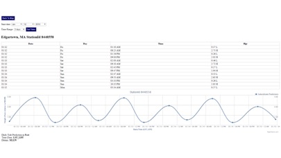
3. Advanced tide graphs allow for you to judge the level of water movement for optimal fishing between high and low tide in Massachusetts between tide stations so you can follow the tide flow for the entire day.
4. "NesTides ability to display tide predictions and actual tidal flow graphs allow me to extend fishing trips by following different tide station tide charts and moving with the tide flow.
5. Ability to forecast Massachusetts tides from NOAA by setting date and period for any of the tidal stations for the entire State of Massachusetts tide tables.
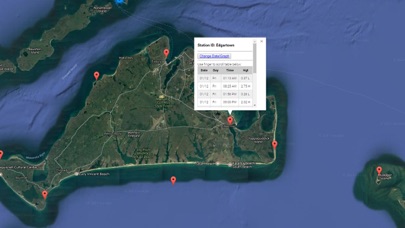
6. Accurate, simple to use Satellite Map based Massachusetts tide charts of the all NOAA based Massachusetts tide stations on a simple to use satellite map.
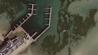
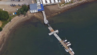
7. Included is the ability to zoom and view satellite imagery for fishing ground characteristics to compare with tide movement.
8. Auto-save last location for easy reference to your last tide station the next time you use the tide app.
9. The satellite view allows me to explore and discover new fishing grounds I never knew existed.
10. Designed by Massachusetts fishermen and Professional Massachusetts Fishing Guides.
11. Excellent support for any issues, questions or new features...simply email: info@nestides.com and we'll show you how Apple support is meant to be.
Vérifier les applications ou alternatives PC compatibles
| App | Télécharger | Évaluation | Écrit par |
|---|---|---|---|
|
Massachusetts Tide Chart
|
Obtenir une application ou des alternatives ↲ | 1 1.00
|
NesTides |
Ou suivez le guide ci-dessous pour l'utiliser sur PC :
Choisissez votre version PC:
Configuration requise pour l'installation du logiciel:
Disponible pour téléchargement direct. Téléchargez ci-dessous:
Maintenant, ouvrez l'application Emulator que vous avez installée et cherchez sa barre de recherche. Une fois que vous l'avez trouvé, tapez Massachusetts Tide Chart dans la barre de recherche et appuyez sur Rechercher. Clique sur le Massachusetts Tide Chartnom de l'application. Une fenêtre du Massachusetts Tide Chart sur le Play Store ou le magasin d`applications ouvrira et affichera le Store dans votre application d`émulation. Maintenant, appuyez sur le bouton Installer et, comme sur un iPhone ou un appareil Android, votre application commencera à télécharger. Maintenant nous avons tous fini.
Vous verrez une icône appelée "Toutes les applications".
Cliquez dessus et il vous mènera à une page contenant toutes vos applications installées.
Tu devrais voir le icône. Cliquez dessus et commencez à utiliser l'application.
Obtenir un APK compatible pour PC
| Télécharger | Écrit par | Évaluation | Version actuelle |
|---|---|---|---|
| Télécharger APK pour PC » | NesTides | 1.00 | 1.0 |
Télécharger Massachusetts Tide Chart pour Mac OS (Apple)
| Télécharger | Écrit par | Critiques | Évaluation |
|---|---|---|---|
| $9.99 pour Mac OS | NesTides | 1 | 1.00 |

Florida Tides & Fishing Regs

Gulf of Mexico Tide Tables

Southeastern Tidal Times

Chesapeake - Tidewater Tides

Northeast U.S.A. Tide Tables

Météo & Radar

Thermomètre réel

YoWindow Météo

RainToday

Météo-France

Thermomètre º

YoWindow, une météo précise

La Chaîne Météo

La météo agricole

Windy.com

SimClimat

Meteociel

Température de chambre

Skiinfo

Météo Live: Prévisions Locales
 PcMac Français