
أرسلت بواسطة أرسلت بواسطة Jeff Maynard
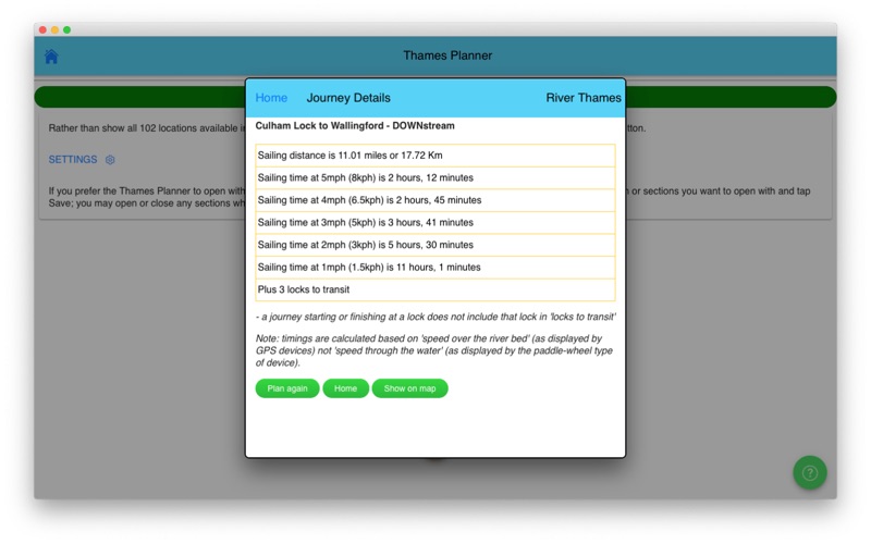
1. JOURNEY PLANNER: select a starting point and destination from the supplied list of 102 landmarks (including locks, marinas, moorings, bridges and places of interest (from Lechlade to the Thames Barrier) and immediately see the sailing distance, direction (up or downstream), sailing time (at 5 mph, 3 mph and 1 mph) and the number of locks to transit to complete your journey; Wey navigation planner features 45 locations.
2. Add any combination of locks, moorings, boatyards, fuel, marinas, pubs, restaurants, lodgings, sanitation, fishing, emergency RVP and/or bridges; tapping any icon pops up further details including phone number, post code, maximum stay etc (where available).
3. IN CASE OF EMERGENCY: River Thames Guide includes an SOS section with information, endorsed by the RNLI, on how to deal with various problems including: Man Overboard; Boat Sinking; Boat on Fire; Boat Drifting.
4. CURRENT RIVER CONDITIONS: for safer river use always verify the current official conditions before setting off; non-tidal conditions are provided by the Environment Agency (the River Thames authority) and categorised as Red, Yellow or Green – tap to view an explanation of the colours.
5. Touch any lock to see much more information including: telephone number; post code; lock type; width, drop and length; lock keeper’s hours; facilities available (such as WC, water, pump out etc).
6. HELP: every page contains tips on using River Thames Guide to help plan your journey, find somewhere to eat or stay, using the map, and more.
7. LOCK FEATURES: every Thames lock is listed in order from Cricklade Bridge to Teddington with distance to next lock both up and downstream.
8. The interactive map is built-in to the App so you do not need an Internet connection to see where you are and facilities near you (PLEASE NOTE: this means a large download - please be patient, it’s worth it!).
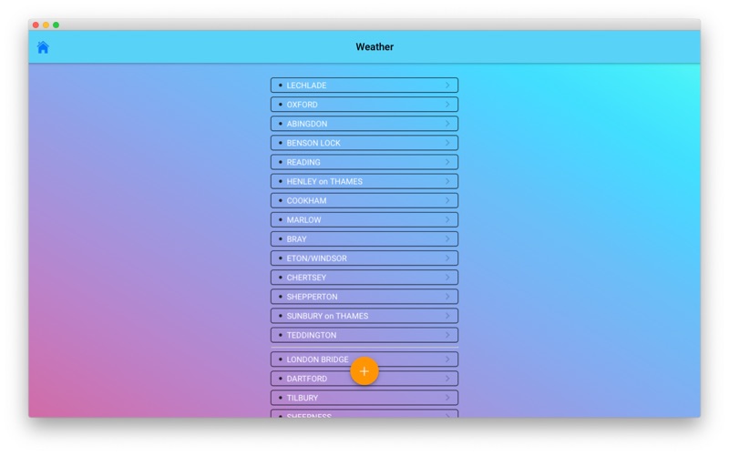
9. WEATHER: select one of 20 location on the river for an up-to-date weather forecast for today and tomorrow (includes temperature, winds, humidity, visibility, sunrise and sunset).
10. BRIDGE HEADWAY: every bridge listed in order with headway in feet and metres; bridge headways are colour coded for ease of use and instant check to see if you need to lower any masts.
11. INTERACTIVE RIVER MAP: pinch or squeeze to zoom to the required level of detail.


تحقق من تطبيقات الكمبيوتر المتوافقة أو البدائل
| التطبيق | تحميل | تقييم | المطور |
|---|---|---|---|
|
RiverThamesGuide
|
احصل على التطبيق أو البدائل ↲ | 0 1
|
Jeff Maynard |
أو اتبع الدليل أدناه لاستخدامه على جهاز الكمبيوتر :
اختر إصدار الكمبيوتر الشخصي لديك:
متطلبات تثبيت البرنامج:
متاح للتنزيل المباشر. تنزيل أدناه:
الآن ، افتح تطبيق Emulator الذي قمت بتثبيته وابحث عن شريط البحث الخاص به. بمجرد العثور عليه ، اكتب اسم التطبيق في شريط البحث واضغط على Search. انقر على أيقونة التطبيق. سيتم فتح نافذة من التطبيق في متجر Play أو متجر التطبيقات وستعرض المتجر في تطبيق المحاكي. الآن ، اضغط على زر التثبيت ومثل على جهاز iPhone أو Android ، سيبدأ تنزيل تطبيقك. الآن كلنا انتهينا. <br> سترى أيقونة تسمى "جميع التطبيقات". <br> انقر عليه وسيأخذك إلى صفحة تحتوي على جميع التطبيقات المثبتة. <br> يجب أن ترى رمز التطبيق. اضغط عليها والبدء في استخدام التطبيق. RiverThamesGuide messages.step31_desc RiverThamesGuidemessages.step32_desc RiverThamesGuide messages.step33_desc messages.step34_desc
احصل على ملف APK متوافق للكمبيوتر الشخصي
| تحميل | المطور | تقييم | الإصدار الحالي |
|---|---|---|---|
| تحميل APK للكمبيوتر الشخصي » | Jeff Maynard | 1 | 33.236 |
تحميل RiverThamesGuide إلى عن على Mac OS (Apple)
| تحميل | المطور | التعليقات | تقييم |
|---|---|---|---|
| Free إلى عن على Mac OS | Jeff Maynard | 0 | 1 |

Airport Codes Database

River Thames Guide

River Thames Guide Lite

Eurosceptic

Airport Airline Codes Database

inDriver: Better than a taxi

Wizz Air

Uber

Swvl - Bus Booking App

Booking.com Travel Deals

Careem - Rides, Food, Delivery

DiDi-Rider

Zoomcar-Self drive Car rental
Google Earth

Egypt Trains

Mwasalat Misr

GoBus

Rehlat- Flight, Hotels, & Bus

WiFi Map TripBox: Find Hotspot

Wego Flights & Hotels Booking
 PcMac عربى