Last Updated by Flytomap on 2025-04-03
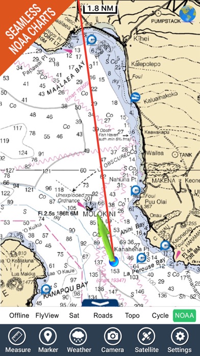

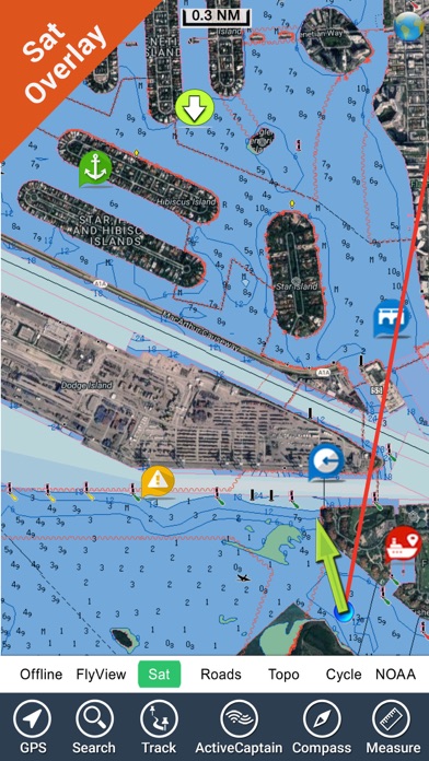

What is Boating Hawaii GPS kml map nautical fishing charts? Flytomap is a navigation app that provides worldwide marine and outdoor maps, satellite images overlay on charts, terrain features overlay on charts, local marine weather forecast, NOAA raster charts, and ActiveCaptain - a worldwide boaters community. The app allows users to explore their favorite places, search for favorite points, zoom, rotate, and pan fast just by a finger touch, get quick object information just tapping, use GPS heading vector towards the direction movement, measure distance, plan routes, insert waypoints, and select depth contours. The app also features a la carte menu, MOB (Man Over Board), quick WP, iOS background mode, optimized battery usage, and more.
1. Flytomap is committed to constant improvement, this App is developed with the help of professional boaters to get the best experience on the sea, we listen to our users and systematically add the most requested features.
2. √ iOS background mode - Flytomap works in background as well, you can swap with another app and receive/make calls send sms while track recording.
3. Hawaii coverage resident in the app.
4. Liked Boating Hawaii GPS kml map nautical fishing charts? here are 5 Navigation apps like Hawaii Travel Guide ..; Hawaii Bikes - Unofficial; Hawaii GPS Nautical Charts; Marine : Hawaii HD - GPS Map Navigator; Hawaii Raster Maps;
GET Compatible PC App
| App | Download | Rating | Maker |
|---|---|---|---|
 Boating Hawaii GPS kml map nautical fishing charts Boating Hawaii GPS kml map nautical fishing charts |
Get App ↲ | 1 1.00 |
Flytomap |
Or follow the guide below to use on PC:
Select Windows version:
Install Boating Hawaii GPS kml map nautical fishing charts app on your Windows in 4 steps below:
Download a Compatible APK for PC
| Download | Developer | Rating | Current version |
|---|---|---|---|
| Get APK for PC → | Flytomap | 1.00 | 5.5 |
Get Boating Hawaii GPS kml map nautical fishing charts on Apple macOS
| Download | Developer | Reviews | Rating |
|---|---|---|---|
| Get $4.99 on Mac | Flytomap | 1 | 1.00 |
Download on Android: Download Android
- Worldwide marine and outdoor maps available when connected
- Worldwide satellite images overlay on charts
- Worldwide terrain features overlay on charts
- Local marine weather forecast
- NOAA raster charts seamless with continuous updates from the official Government server
- ActiveCaptain - worldwide boaters community with 200,000+ captains
- Latitudes and longitudes to go to favorite places
- Search favorite points directly
- Zoom, rotate, and pan fast just by a finger touch
- Quick object information just tapping, thanks to vector technology
- GPS heading vector towards the direction movement
- Distance measurement tool to easily calculate the distance from one location to another
- Route planning, waypoints - insert the target/destination and see in real-time speed, distance, and bearing
- Magnified lens for all info
- Unlimited tracks, markers, geo-tagged photos, records, and share via email, visible on Google, Flytomap Viewer, KMZ format - store track without the need for cellular data or mobile signal
- Select depth contours
- A la carte menu
- MOB - Man Over Board
- Quick WP - allows instantly recording position and show distance and bearing
- iOS background mode - Flytomap works in the background as well, you can swap with another app and receive/make calls send SMS while track recording
- Optimized battery usage
- Local marine weather forecast at a quick tap provides day max and min temperature, current temperature, significant wave height, swell height, swell period, swell direction, tide data, sea temperature, wind speed and direction, weather description, precipitation and humidity, visibility, pressure, cloud cover in percentage, wind chill/feels like temperature, water temperature, dew point temperature, and heat index temperature.
- Great maps with outstanding and user-friendly features
- Suitable for boating, on land travel, and backpacking
- Large map coverage with more details for landmarks
- Great UI and information
- Works well on both iPhone and iPad
- Stable and reliable, never crashes or has any problems
- None mentioned in the review
Awesome Info.
Worth
Excellent app
Niceee
 PC Apps